![](/images/other/stat-length.png)
Cinque Terre, Monterosso, Vernazza, Corniglia, Manarola, Riomaggiore
ericberlin
User
![Length](/images/other/stat-length.png)
Length
22 km
![Max alt](https://static1.geolcdn.com/siteimages/upload/files/1508320355ic_sort_altitude_max_24dp.png)
Max alt
536 m
![Uphill gradient](https://static1.geolcdn.com/siteimages/upload/files/1508320355ic_sort_den_pos_24dp.png)
Uphill gradient
1501 m
![Km-Effort](/images/other/stat-length.png)
Km-Effort
42 km
![Min alt](https://static1.geolcdn.com/siteimages/upload/files/1508320355ic_sort_altitude_min_24dp.png)
Min alt
-6 m
![Downhill gradient](https://static1.geolcdn.com/siteimages/upload/files/1508320355ic_sort_den_neg_24dp.png)
Downhill gradient
1457 m
![Boucle](https://static1.geolcdn.com/siteimages/upload/files/16400158638029165_repeat_loop_refresh_sync_direction_icon.png)
Boucle
No
Creation date :
2022-10-30 08:20:41.266
Updated on :
2023-06-05 15:55:26.695
![Walking](https://static1.geolcdn.com/sitytour/trail-icons/101.png)
9h33
Difficulty : Very difficult
![Scan this QR Code to open this trail in the SityTrail application](https://capi.geolives.com/qq0zvz2zws4bq2lad0pu/sitytour/trails/3440335/qr.png?size=200)
FREE GPS app for hiking
About
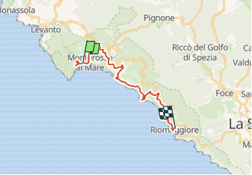
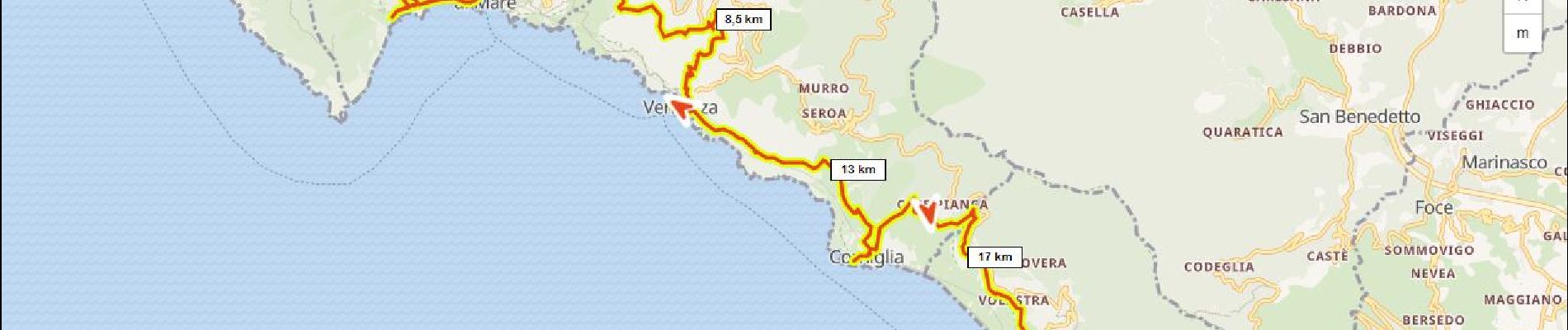
Trail Walking of 22 km to be discovered at Liguria, La Spezia, Monterosso al Mare. This trail is proposed by ericberlin.
Description
Projet de tracé pour plusieurs jours
Sources:
https://hiking.waymarkedtrails.org/
https://www.i-trekkings.net/
https://www.baladescotieres.com
http://www.parconazionale5terre.it/
https://www.cailaspezia.it/
Positioning
Country:
Italy
Region :
Liguria
Department/Province :
La Spezia
Municipality :
Monterosso al Mare
Location:
Unknown
Start:(Dec)
Start:(UTM)
551905 ; 4888280 (32T) N.
Comments
Trails nearby
![Trail Walking Vernazza - Rando cinq Terre 4ème jour Vernazza-Riomaggiore - Photo](https://media.geolcdn.com/t/375/260/f9331efa-b16c-4633-8239-c8a50683b624.jpg&format=jpg&maxdim=2)
![Walking Walking](https://static1.geolcdn.com/sitytour/trail-icons/101.png)
Rando cinq Terre 4ème jour Vernazza-Riomaggiore
Walking
Very difficult
(1)
Vernazza,
Liguria,
La Spezia,
Italy
![](/images/other/stat-length.png)
12.4 km | 23 km-effort
4h 26min
![](https://static1.geolcdn.com/siteimages/upload/files/16400158638029165_repeat_loop_refresh_sync_direction_icon.png)
No
![Trail Walking Vernazza - Fernacchi - manarola - Photo](https://media.geolcdn.com/t/375/260/ext.jpg?maxdim=2&url=https%3A%2F%2Fstatic1.geolcdn.com%2Fsiteimages%2Fupload%2Ffiles%2F1553511878bg_sport_marche.png)
![Walking Walking](https://static1.geolcdn.com/sitytour/trail-icons/101.png)
Fernacchi - manarola
Walking
Easy
(1)
Vernazza,
Liguria,
La Spezia,
Italy
![](/images/other/stat-length.png)
5.8 km | 9.7 km-effort
2h 12min
![](https://static1.geolcdn.com/siteimages/upload/files/16400158638029165_repeat_loop_refresh_sync_direction_icon.png)
No
![Trail Walking Levanto - Levanto - Vernazza 6.5.23 - Photo](https://media.geolcdn.com/t/375/260/0287dcd3-7795-4c8b-8f35-962c00e797c3.jpg&format=jpg&maxdim=2)
![Walking Walking](https://static1.geolcdn.com/sitytour/trail-icons/101.png)
Levanto - Vernazza 6.5.23
Walking
Difficult
Levanto,
Liguria,
La Spezia,
Italy
![](/images/other/stat-length.png)
14.1 km | 23 km-effort
5h 0min
![](https://static1.geolcdn.com/siteimages/upload/files/16400158638029165_repeat_loop_refresh_sync_direction_icon.png)
No
![Trail On foot Levanto - Vallesanta - Monte delle Streghe - Colletto - Photo](https://media.geolcdn.com/t/375/260/efa63fd2-8e4e-4cf6-bbf2-2f4e4541a575.jpeg&format=jpg&maxdim=2)
![On foot On foot](https://static1.geolcdn.com/sitytour/trail-icons/100.png)
Vallesanta - Monte delle Streghe - Colletto
On foot
Easy
Levanto,
Liguria,
La Spezia,
Italy
![](/images/other/stat-length.png)
4.6 km | 9.5 km-effort
2h 9min
![](https://static1.geolcdn.com/siteimages/upload/files/16400158638029165_repeat_loop_refresh_sync_direction_icon.png)
No
![Trail On foot Levanto - Il Termine – Mad.di Soviore – Colla di Gritta – S.Antonio al Mesco - Photo](https://media.geolcdn.com/t/375/260/7d93da1b-0b41-4fef-acc9-26fc84562262.jpeg&format=jpg&maxdim=2)
![On foot On foot](https://static1.geolcdn.com/sitytour/trail-icons/100.png)
Il Termine – Mad.di Soviore – Colla di Gritta – S.Antonio al Mesco
On foot
Easy
Levanto,
Liguria,
La Spezia,
Italy
![](/images/other/stat-length.png)
7.4 km | 12.6 km-effort
2h 52min
![](https://static1.geolcdn.com/siteimages/upload/files/16400158638029165_repeat_loop_refresh_sync_direction_icon.png)
No
![Trail On foot Levanto - Levanto - Montale - Foce di Montale - Valle Carbonetta - Photo](https://media.geolcdn.com/t/375/260/f14c232d-65b5-4ec2-b169-eb236882792a.jpeg&format=jpg&maxdim=2)
![On foot On foot](https://static1.geolcdn.com/sitytour/trail-icons/100.png)
Levanto - Montale - Foce di Montale - Valle Carbonetta
On foot
Easy
Levanto,
Liguria,
La Spezia,
Italy
![](/images/other/stat-length.png)
6.3 km | 11.5 km-effort
2h 37min
![](https://static1.geolcdn.com/siteimages/upload/files/16400158638029165_repeat_loop_refresh_sync_direction_icon.png)
No
![Trail On foot Levanto - Tuvo – C.sa Massola – M.Focone - innesto 591 - Photo](https://media.geolcdn.com/t/375/260/ad9ed57f-9477-4e43-95c5-11010ee7449f.jpeg&format=jpg&maxdim=2)
![On foot On foot](https://static1.geolcdn.com/sitytour/trail-icons/100.png)
Tuvo – C.sa Massola – M.Focone - innesto 591
On foot
Easy
Levanto,
Liguria,
La Spezia,
Italy
![](/images/other/stat-length.png)
3.4 km | 7.2 km-effort
1h 38min
![](https://static1.geolcdn.com/siteimages/upload/files/16400158638029165_repeat_loop_refresh_sync_direction_icon.png)
No
![Trail On foot Levanto - Pian di Barca – Mad. del Trezzo – Pignone - M. Martinasca – M. Crocettola - Photo](https://media.geolcdn.com/t/375/260/7d93da1b-0b41-4fef-acc9-26fc84562262.jpeg&format=jpg&maxdim=2)
![On foot On foot](https://static1.geolcdn.com/sitytour/trail-icons/100.png)
Pian di Barca – Mad. del Trezzo – Pignone - M. Martinasca – M. Crocettola
On foot
Easy
Levanto,
Liguria,
La Spezia,
Italy
![](/images/other/stat-length.png)
3.7 km | 5.8 km-effort
1h 19min
![](https://static1.geolcdn.com/siteimages/upload/files/16400158638029165_repeat_loop_refresh_sync_direction_icon.png)
No
![Trail On foot Levanto - Pié di Fontona – Fontona - Colla di Gritta - Photo](https://media.geolcdn.com/t/375/260/f14c232d-65b5-4ec2-b169-eb236882792a.jpeg&format=jpg&maxdim=2)
![On foot On foot](https://static1.geolcdn.com/sitytour/trail-icons/100.png)
Pié di Fontona – Fontona - Colla di Gritta
On foot
Easy
Levanto,
Liguria,
La Spezia,
Italy
![](/images/other/stat-length.png)
4 km | 7.3 km-effort
1h 39min
![](https://static1.geolcdn.com/siteimages/upload/files/16400158638029165_repeat_loop_refresh_sync_direction_icon.png)
No