![](/images/other/stat-length.png)
Valle della Ferriere + Pontone CAI325 + CAI323a
ericberlin
User
![Length](/images/other/stat-length.png)
Length
6.4 km
![Max alt](https://static1.geolcdn.com/siteimages/upload/files/1508320355ic_sort_altitude_max_24dp.png)
Max alt
342 m
![Uphill gradient](https://static1.geolcdn.com/siteimages/upload/files/1508320355ic_sort_den_pos_24dp.png)
Uphill gradient
398 m
![Km-Effort](/images/other/stat-length.png)
Km-Effort
11.7 km
![Min alt](https://static1.geolcdn.com/siteimages/upload/files/1508320355ic_sort_altitude_min_24dp.png)
Min alt
8 m
![Downhill gradient](https://static1.geolcdn.com/siteimages/upload/files/1508320355ic_sort_den_neg_24dp.png)
Downhill gradient
398 m
![Boucle](https://static1.geolcdn.com/siteimages/upload/files/16400158638029165_repeat_loop_refresh_sync_direction_icon.png)
Boucle
Yes
Creation date :
2022-10-29 16:01:22.381
Updated on :
2023-06-05 15:57:59.275
![Walking](https://static1.geolcdn.com/sitytour/trail-icons/101.png)
2h22
Difficulty : Medium
![Scan this QR Code to open this trail in the SityTrail application](https://capi.geolives.com/qq0zvz2zws4bq2lad0pu/sitytour/trails/3439743/qr.png?size=200)
FREE GPS app for hiking
About
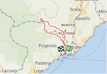
Trail Walking of 6.4 km to be discovered at Campania, Salerno, Amalfi. This trail is proposed by ericberlin.
Description
Tracé d'après
https://www.caimontilattari.it/en/sentiero/325/
https://www.caimontilattari.it/en/sentiero/323a/
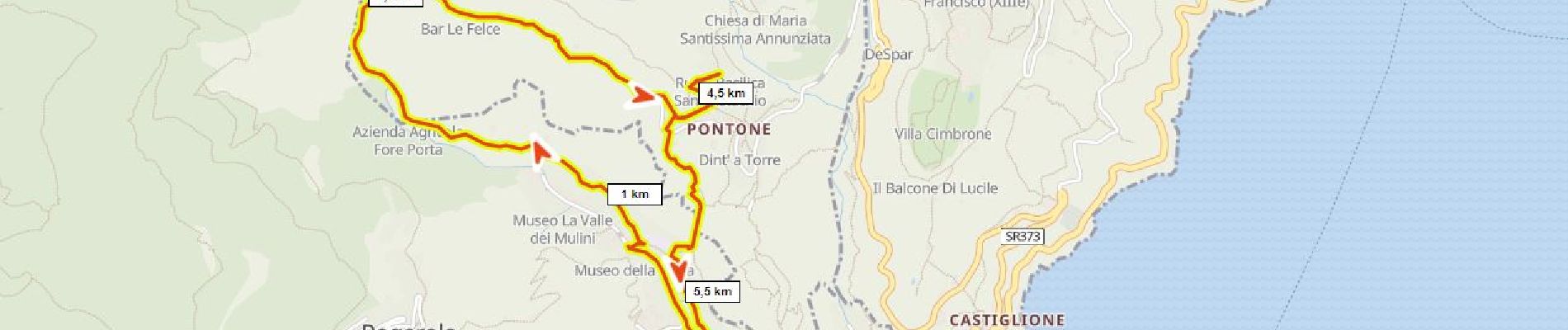
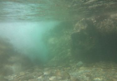
Cascades et vestige d'aqueduc en fond de vallée (sortir du tracé?)
Ruines de la basilica Sant'Eustachio à Pontone.
Belvédère.
Positioning
Country:
Italy
Region :
Campania
Department/Province :
Salerno
Municipality :
Amalfi
Location:
Unknown
Start:(Dec)
Start:(UTM)
466346 ; 4498127 (33T) N.
Comments
Trails nearby
![Trail On foot Agerola - Via Maestra dei Villaggi - Photo](https://media.geolcdn.com/t/375/260/ext.jpg?maxdim=2&url=https%3A%2F%2Fmedia.geolcdn.com%2Ff%2F1522fba5-8abc-4309-858f-0f6afdf484bf.jpeg)
![On foot On foot](https://static1.geolcdn.com/sitytour/trail-icons/100.png)
Via Maestra dei Villaggi
On foot
Easy
Agerola,
Campania,
Napoli,
Italy
![](/images/other/stat-length.png)
4.9 km | 8.1 km-effort
1h 50min
![](https://static1.geolcdn.com/siteimages/upload/files/16400158638029165_repeat_loop_refresh_sync_direction_icon.png)
No
![Trail On foot Scala - Sentiero dei Castagneti di Tavernate - Photo](https://media.geolcdn.com/t/375/260/ext.jpg?maxdim=2&url=https%3A%2F%2Fmedia.geolcdn.com%2Ff%2F99c75066-dc76-4fb0-8504-116a41cbe8e2.jpeg)
![On foot On foot](https://static1.geolcdn.com/sitytour/trail-icons/100.png)
Sentiero dei Castagneti di Tavernate
On foot
Easy
Scala,
Campania,
Salerno,
Italy
![](/images/other/stat-length.png)
4.1 km | 6.8 km-effort
1h 33min
![](https://static1.geolcdn.com/siteimages/upload/files/16400158638029165_repeat_loop_refresh_sync_direction_icon.png)
No
![Trail On foot Ravello - Sentiero di S.Maria ai Monti - Photo](https://media.geolcdn.com/t/375/260/ext.jpg?maxdim=2&url=https%3A%2F%2Fmedia.geolcdn.com%2Ff%2F15275d03-face-4989-9a37-4b07718206fa.jpeg)
![On foot On foot](https://static1.geolcdn.com/sitytour/trail-icons/100.png)
Sentiero di S.Maria ai Monti
On foot
Easy
Ravello,
Campania,
Salerno,
Italy
![](/images/other/stat-length.png)
4.7 km | 11.4 km-effort
2h 34min
![](https://static1.geolcdn.com/siteimages/upload/files/16400158638029165_repeat_loop_refresh_sync_direction_icon.png)
No
![Trail On foot Atrani - IT-351 - Photo](https://media.geolcdn.com/t/375/260/ext.jpg?maxdim=2&url=https%3A%2F%2Fmedia.geolcdn.com%2Ff%2F037db854-d0f9-4b3a-920a-503da51b15d9.jpeg)
![On foot On foot](https://static1.geolcdn.com/sitytour/trail-icons/100.png)
![Trail On foot Furore - Sentiero dei Pipistrelli Impazziti - Photo](https://media.geolcdn.com/t/375/260/ext.jpg?maxdim=2&url=https%3A%2F%2Fmedia.geolcdn.com%2Ff%2F8f4fa053-ea96-443f-8e01-6d2ee8565707.jpeg)
![On foot On foot](https://static1.geolcdn.com/sitytour/trail-icons/100.png)
Sentiero dei Pipistrelli Impazziti
On foot
Easy
Furore,
Campania,
Salerno,
Italy
![](/images/other/stat-length.png)
3.8 km | 8.1 km-effort
1h 50min
![](https://static1.geolcdn.com/siteimages/upload/files/16400158638029165_repeat_loop_refresh_sync_direction_icon.png)
No
![Trail On foot Maiori - IT-315a - Photo](https://media.geolcdn.com/t/375/260/ext.jpg?maxdim=2&url=https%3A%2F%2Fmedia.geolcdn.com%2Ff%2Fbea3ade9-b57c-4c2c-9f6c-639aebf1ce5a.jpeg)
![On foot On foot](https://static1.geolcdn.com/sitytour/trail-icons/100.png)
![Trail On foot Ravello - IT-315 - Photo](https://media.geolcdn.com/t/375/260/ext.jpg?maxdim=2&url=https%3A%2F%2Fmedia.geolcdn.com%2Ff%2Fdd9589c0-e1d7-4dbc-9f6a-2e608e834fab.jpeg)
![On foot On foot](https://static1.geolcdn.com/sitytour/trail-icons/100.png)
![Trail On foot Scala - Sentiero alto della Valle delle Ferriere - Photo](https://media.geolcdn.com/t/375/260/ext.jpg?maxdim=2&url=https%3A%2F%2Fmedia.geolcdn.com%2Ff%2F4c413f0a-7a02-4b95-a2da-66ff449fe626.jpeg)
![On foot On foot](https://static1.geolcdn.com/sitytour/trail-icons/100.png)
Sentiero alto della Valle delle Ferriere
On foot
Medium
Scala,
Campania,
Salerno,
Italy
![](/images/other/stat-length.png)
14.2 km | 25 km-effort
5h 41min
![](https://static1.geolcdn.com/siteimages/upload/files/16400158638029165_repeat_loop_refresh_sync_direction_icon.png)
No
![Trail On foot Minori - IT-315d - Photo](https://media.geolcdn.com/t/375/260/ext.jpg?maxdim=2&url=https%3A%2F%2Fmedia.geolcdn.com%2Ff%2F56d8d677-4f9a-416a-9d49-9d36c1abfeb3.jpeg)
![On foot On foot](https://static1.geolcdn.com/sitytour/trail-icons/100.png)