![](/images/other/stat-length.png)
![Trail Walking Mornand-en-Forez - Mornand le Moulin - Photo](https://media.geolcdn.com/t/1900/400/ext.pjpeg?maxdim=2&url=https%3A%2F%2Fservices.sitytrail.com%2FGeolivesWS%2FDownloadMedia.ashx%3FTrailID%3D343705%26Media%3D20140603152022.jpg)
Mornand le Moulin
gannet1
User
![Length](/images/other/stat-length.png)
Length
5.1 km
![Max alt](https://static1.geolcdn.com/siteimages/upload/files/1508320355ic_sort_altitude_max_24dp.png)
Max alt
359 m
![Uphill gradient](https://static1.geolcdn.com/siteimages/upload/files/1508320355ic_sort_den_pos_24dp.png)
Uphill gradient
33 m
![Km-Effort](/images/other/stat-length.png)
Km-Effort
5.5 km
![Min alt](https://static1.geolcdn.com/siteimages/upload/files/1508320355ic_sort_altitude_min_24dp.png)
Min alt
343 m
![Downhill gradient](https://static1.geolcdn.com/siteimages/upload/files/1508320355ic_sort_den_neg_24dp.png)
Downhill gradient
31 m
![Boucle](https://static1.geolcdn.com/siteimages/upload/files/16400158638029165_repeat_loop_refresh_sync_direction_icon.png)
Boucle
Yes
Creation date :
2014-12-18 00:00:00.0
Updated on :
2014-12-18 00:00:00.0
![Walking](https://static1.geolcdn.com/sitytour/trail-icons/101.png)
1h13
Difficulty : Unknown
![Scan this QR Code to open this trail in the SityTrail application](https://capi.geolives.com/qq0zvz2zws4bq2lad0pu/sitytour/trails/343705/qr.png?size=200)
FREE GPS app for hiking
About
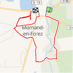
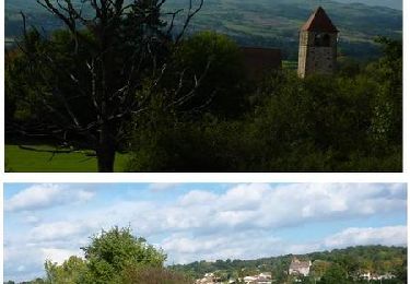
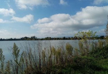
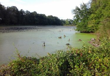
Trail Walking of 5.1 km to be discovered at Auvergne-Rhône-Alpes, Loire, Mornand-en-Forez. This trail is proposed by gannet1.
Description
Autour de Mornand et passage près d'un moulin et de l'étang Durand.
Testé par le groupe de marche de SELM.
Positioning
Country:
France
Region :
Auvergne-Rhône-Alpes
Department/Province :
Loire
Municipality :
Mornand-en-Forez
Location:
Unknown
Start:(Dec)
Start:(UTM)
587798 ; 5059153 (31T) N.
Comments
Trails nearby
![Trail Walking Montverdun - Randonnée autour de Montverdun - Photo](https://media.geolcdn.com/t/375/260/64d529f3-750c-4edd-b848-97cd9687592e.jpg&format=jpg&maxdim=2)
![Walking Walking](https://static1.geolcdn.com/sitytour/trail-icons/101.png)
Randonnée autour de Montverdun
Walking
Easy
Montverdun,
Auvergne-Rhône-Alpes,
Loire,
France
![](/images/other/stat-length.png)
15.7 km | 17.6 km-effort
2h 59min
![](https://static1.geolcdn.com/siteimages/upload/files/16400158638029165_repeat_loop_refresh_sync_direction_icon.png)
Yes
![Trail Mountain bike Chalain-d'Uzore - 11ème Croix d'Automne (2013-VTT-50km) - Chalain d'Uzore - Photo](https://media.geolcdn.com/t/375/260/ext.jpg?maxdim=2&url=https%3A%2F%2Fservices.sitytrail.com%2FGeolivesWS%2FDownloadMedia.ashx%3FTrailID%3D317102%26Media%3D16250_6.jpg)
![Mountain bike Mountain bike](https://static1.geolcdn.com/sitytour/trail-icons/202.png)
11ème Croix d'Automne (2013-VTT-50km) - Chalain d'Uzore
Mountain bike
Very difficult
Chalain-d'Uzore,
Auvergne-Rhône-Alpes,
Loire,
France
![](/images/other/stat-length.png)
50 km | 68 km-effort
4h 30min
![](https://static1.geolcdn.com/siteimages/upload/files/16400158638029165_repeat_loop_refresh_sync_direction_icon.png)
Yes
![Trail Mountain bike Chalain-d'Uzore - 10ème Croix d'Automne (2012-VTT-70km) - Chalain d'Uzore - Photo](https://media.geolcdn.com/t/375/260/ext.jpg?maxdim=2&url=https%3A%2F%2Fservices.sitytrail.com%2FGeolivesWS%2FDownloadMedia.ashx%3FTrailID%3D172893%26Media%3D14352_6.jpg)
![Mountain bike Mountain bike](https://static1.geolcdn.com/sitytour/trail-icons/202.png)
10ème Croix d'Automne (2012-VTT-70km) - Chalain d'Uzore
Mountain bike
Very difficult
Chalain-d'Uzore,
Auvergne-Rhône-Alpes,
Loire,
France
![](/images/other/stat-length.png)
70 km | 96 km-effort
6h 0min
![](https://static1.geolcdn.com/siteimages/upload/files/16400158638029165_repeat_loop_refresh_sync_direction_icon.png)
Yes
![Trail Mountain bike Chalain-d'Uzore - VTT Chalain d'Uzore - 8ème Croix d'automne - Photo](https://media.geolcdn.com/t/375/260/ext.jpg?maxdim=2&url=https%3A%2F%2Fservices.sitytrail.com%2FGeolivesWS%2FDownloadMedia.ashx%3FTrailID%3D105801%26Media%3D9714_6.jpg)
![Mountain bike Mountain bike](https://static1.geolcdn.com/sitytour/trail-icons/202.png)
VTT Chalain d'Uzore - 8ème Croix d'automne
Mountain bike
Very difficult
Chalain-d'Uzore,
Auvergne-Rhône-Alpes,
Loire,
France
![](/images/other/stat-length.png)
67 km | 92 km-effort
5h 0min
![](https://static1.geolcdn.com/siteimages/upload/files/16400158638029165_repeat_loop_refresh_sync_direction_icon.png)
Yes
![Trail Walking Chambéon - Départ au Chambeon, ecopole du forez - Photo](https://media.geolcdn.com/t/375/260/1734c18c-0877-4056-b2fa-29a2afb39e0b.jpg&format=jpg&maxdim=2)
![Walking Walking](https://static1.geolcdn.com/sitytour/trail-icons/101.png)
Départ au Chambeon, ecopole du forez
Walking
Very easy
Chambéon,
Auvergne-Rhône-Alpes,
Loire,
France
![](/images/other/stat-length.png)
8.2 km | 8.6 km-effort
2h 35min
![](https://static1.geolcdn.com/siteimages/upload/files/16400158638029165_repeat_loop_refresh_sync_direction_icon.png)
No
![Trail Other activity Champdieu - Vaugirard 10.09.17 - Photo](https://media.geolcdn.com/t/375/260/ext.jpg?maxdim=2&url=https%3A%2F%2Fservices.sitytrail.com%2FGeolivesWS%2FDownloadMedia.ashx%3FTrailID%3D827752%26Media%3Dfix__20170910181154.jpg)
![Other activity Other activity](https://static1.geolcdn.com/sitytour/trail-icons/900.png)
Vaugirard 10.09.17
Other activity
Very easy
Champdieu,
Auvergne-Rhône-Alpes,
Loire,
France
![](/images/other/stat-length.png)
6.5 km | 7 km-effort
2h 19min
![](https://static1.geolcdn.com/siteimages/upload/files/16400158638029165_repeat_loop_refresh_sync_direction_icon.png)
Yes
![Trail Mountain bike Mornand-en-Forez - t - Photo](https://media.geolcdn.com/t/375/260/ext.jpg?maxdim=2&url=https%3A%2F%2Fstatic1.geolcdn.com%2Fsiteimages%2Fupload%2Ffiles%2F1524743154velo.jpg)
![Mountain bike Mountain bike](https://static1.geolcdn.com/sitytour/trail-icons/202.png)
t
Mountain bike
Medium
Mornand-en-Forez,
Auvergne-Rhône-Alpes,
Loire,
France
![](/images/other/stat-length.png)
21 km | 23 km-effort
57min
![](https://static1.geolcdn.com/siteimages/upload/files/16400158638029165_repeat_loop_refresh_sync_direction_icon.png)
Yes
![Trail Mountain bike Mornand-en-Forez - chute - Photo](https://media.geolcdn.com/t/375/260/ext.jpg?maxdim=2&url=https%3A%2F%2Fstatic1.geolcdn.com%2Fsiteimages%2Fupload%2Ffiles%2F1524743154velo.jpg)
![Mountain bike Mountain bike](https://static1.geolcdn.com/sitytour/trail-icons/202.png)
chute
Mountain bike
Easy
Mornand-en-Forez,
Auvergne-Rhône-Alpes,
Loire,
France
![](/images/other/stat-length.png)
5.7 km | 6.1 km-effort
23min
![](https://static1.geolcdn.com/siteimages/upload/files/16400158638029165_repeat_loop_refresh_sync_direction_icon.png)
No
![Trail Mountain bike Mornand-en-Forez - Cs - Photo](https://media.geolcdn.com/t/375/260/ext.jpg?maxdim=2&url=https%3A%2F%2Fstatic1.geolcdn.com%2Fsiteimages%2Fupload%2Ffiles%2F1524743154velo.jpg)
![Mountain bike Mountain bike](https://static1.geolcdn.com/sitytour/trail-icons/202.png)
Cs
Mountain bike
Easy
Mornand-en-Forez,
Auvergne-Rhône-Alpes,
Loire,
France
![](/images/other/stat-length.png)
18.5 km | 19.9 km-effort
55min
![](https://static1.geolcdn.com/siteimages/upload/files/16400158638029165_repeat_loop_refresh_sync_direction_icon.png)
Yes