![](/images/other/stat-length.png)
![Trail Walking Sorges et Ligueux en Périgord - Boucle de l'Abbatiale - Photo](https://media.geolcdn.com/t/1900/400/9612e021-d9e0-4a16-be1e-ceb9f3a734d7.jpg&format=pjpeg&maxdim=2)
Boucle de l'Abbatiale
NICOLEROBERT
User
![Length](/images/other/stat-length.png)
Length
7.3 km
![Max alt](https://static1.geolcdn.com/siteimages/upload/files/1508320355ic_sort_altitude_max_24dp.png)
Max alt
214 m
![Uphill gradient](https://static1.geolcdn.com/siteimages/upload/files/1508320355ic_sort_den_pos_24dp.png)
Uphill gradient
126 m
![Km-Effort](/images/other/stat-length.png)
Km-Effort
8.9 km
![Min alt](https://static1.geolcdn.com/siteimages/upload/files/1508320355ic_sort_altitude_min_24dp.png)
Min alt
149 m
![Downhill gradient](https://static1.geolcdn.com/siteimages/upload/files/1508320355ic_sort_den_neg_24dp.png)
Downhill gradient
124 m
![Boucle](https://static1.geolcdn.com/siteimages/upload/files/16400158638029165_repeat_loop_refresh_sync_direction_icon.png)
Boucle
Yes
Creation date :
2022-10-26 07:22:48.295
Updated on :
2022-10-26 10:36:06.19
![Walking](https://static1.geolcdn.com/sitytour/trail-icons/101.png)
2h01
Difficulty : Easy
![Scan this QR Code to open this trail in the SityTrail application](https://capi.geolives.com/qq0zvz2zws4bq2lad0pu/sitytour/trails/3435982/qr.png?size=200)
FREE GPS app for hiking
About
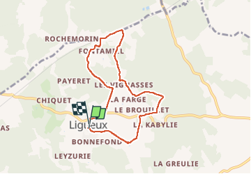
Trail Walking of 7.3 km to be discovered at New Aquitaine, Dordogne, Sorges et Ligueux en Périgord. This trail is proposed by NICOLEROBERT.
Description
Randonnée pedestre autour de l'abbaye de Ligueux,facile à faire en famille, peu de dénivelés
Départ depuisle panneau d'appel situé sur le parking devant la mairie prés du parc de loisirs
Positioning
Country:
France
Region :
New Aquitaine
Department/Province :
Dordogne
Municipality :
Sorges et Ligueux en Périgord
Location:
Unknown
Start:(Dec)
Start:(UTM)
329033 ; 5019424 (31T) N.
Comments
Trails nearby
![Trail sport Sorges et Ligueux en Périgord - 2020-09-03_17h34m25_20-10-20 Ligueux - Photo](https://media.geolcdn.com/t/375/260/ext.jpg?maxdim=2&url=https%3A%2F%2Fsecurestorage.geolives.com%2Fsitytour%2Ftrail-bg%2Fdefault.jpg)
2020-09-03_17h34m25_20-10-20 Ligueux
sport
Very easy
(1)
Sorges et Ligueux en Périgord,
New Aquitaine,
Dordogne,
France
![](/images/other/stat-length.png)
10.5 km | 13.4 km-effort
Unknown
![](https://static1.geolcdn.com/siteimages/upload/files/16400158638029165_repeat_loop_refresh_sync_direction_icon.png)
Yes
![Trail Walking Sorges et Ligueux en Périgord - Sorges Causses et sous bois 10 km - Photo](https://media.geolcdn.com/t/375/260/ext.jpg?maxdim=2&url=https%3A%2F%2Fstatic1.geolcdn.com%2Fsiteimages%2Fupload%2Ffiles%2F1553511878bg_sport_marche.png)
![Walking Walking](https://static1.geolcdn.com/sitytour/trail-icons/101.png)
Sorges Causses et sous bois 10 km
Walking
Easy
(1)
Sorges et Ligueux en Périgord,
New Aquitaine,
Dordogne,
France
![](/images/other/stat-length.png)
9.9 km | 12.6 km-effort
1h 49min
![](https://static1.geolcdn.com/siteimages/upload/files/16400158638029165_repeat_loop_refresh_sync_direction_icon.png)
Yes
![Trail Walking Sorges et Ligueux en Périgord - Sorges Téléthon 2013 11km - Photo](https://media.geolcdn.com/t/375/260/ext.jpg?maxdim=2&url=https%3A%2F%2Fstatic1.geolcdn.com%2Fsiteimages%2Fupload%2Ffiles%2F1553511878bg_sport_marche.png)
![Walking Walking](https://static1.geolcdn.com/sitytour/trail-icons/101.png)
Sorges Téléthon 2013 11km
Walking
Easy
(1)
Sorges et Ligueux en Périgord,
New Aquitaine,
Dordogne,
France
![](/images/other/stat-length.png)
11 km | 13.2 km-effort
2h 57min
![](https://static1.geolcdn.com/siteimages/upload/files/16400158638029165_repeat_loop_refresh_sync_direction_icon.png)
Yes
![Trail Walking Sorges et Ligueux en Périgord - Marche du dimanche 15 janvier à Ligueux - Photo](https://media.geolcdn.com/t/375/260/ca66f548-4426-4827-980d-dc4041496b72.jpg&format=jpg&maxdim=2)
![Walking Walking](https://static1.geolcdn.com/sitytour/trail-icons/101.png)
Marche du dimanche 15 janvier à Ligueux
Walking
Easy
Sorges et Ligueux en Périgord,
New Aquitaine,
Dordogne,
France
![](/images/other/stat-length.png)
6.8 km | 8.6 km-effort
1h 39min
![](https://static1.geolcdn.com/siteimages/upload/files/16400158638029165_repeat_loop_refresh_sync_direction_icon.png)
No
![Trail Walking Sorges et Ligueux en Périgord - De Sorges à Perigueux sur la voie de Compostelle - Photo](https://media.geolcdn.com/t/375/260/4aaf4236-90c5-474d-8de9-7f6175f80c96.jpeg&format=jpg&maxdim=2)
![Walking Walking](https://static1.geolcdn.com/sitytour/trail-icons/101.png)
De Sorges à Perigueux sur la voie de Compostelle
Walking
Very difficult
Sorges et Ligueux en Périgord,
New Aquitaine,
Dordogne,
France
![](/images/other/stat-length.png)
25 km | 31 km-effort
5h 26min
![](https://static1.geolcdn.com/siteimages/upload/files/16400158638029165_repeat_loop_refresh_sync_direction_icon.png)
No
![Trail Walking Sorges et Ligueux en Périgord - Boucle des châteaux - Photo](https://media.geolcdn.com/t/375/260/ba5fb264-42c9-43e2-90fa-f6bdc036a39c.jpg&format=jpg&maxdim=2)
![Walking Walking](https://static1.geolcdn.com/sitytour/trail-icons/101.png)
Boucle des châteaux
Walking
Difficult
Sorges et Ligueux en Périgord,
New Aquitaine,
Dordogne,
France
![](/images/other/stat-length.png)
14.4 km | 17.2 km-effort
3h 54min
![](https://static1.geolcdn.com/siteimages/upload/files/16400158638029165_repeat_loop_refresh_sync_direction_icon.png)
Yes
![Trail Walking Sorges et Ligueux en Périgord - Sorges bois et causse 11km - Photo](https://media.geolcdn.com/t/375/260/ext.jpg?maxdim=2&url=https%3A%2F%2Fstatic1.geolcdn.com%2Fsiteimages%2Fupload%2Ffiles%2F1553511878bg_sport_marche.png)
![Walking Walking](https://static1.geolcdn.com/sitytour/trail-icons/101.png)
Sorges bois et causse 11km
Walking
Difficult
Sorges et Ligueux en Périgord,
New Aquitaine,
Dordogne,
France
![](/images/other/stat-length.png)
10.9 km | 13.9 km-effort
3h 9min
![](https://static1.geolcdn.com/siteimages/upload/files/16400158638029165_repeat_loop_refresh_sync_direction_icon.png)
Yes
![Trail Walking Sorges et Ligueux en Périgord - Ligueux Saint Simeon MILPAS - Photo](https://media.geolcdn.com/t/375/260/ext.jpg?maxdim=2&url=https%3A%2F%2Fstatic1.geolcdn.com%2Fsiteimages%2Fupload%2Ffiles%2F1553511878bg_sport_marche.png)
![Walking Walking](https://static1.geolcdn.com/sitytour/trail-icons/101.png)
Ligueux Saint Simeon MILPAS
Walking
Difficult
Sorges et Ligueux en Périgord,
New Aquitaine,
Dordogne,
France
![](/images/other/stat-length.png)
11.2 km | 13.9 km-effort
2h 59min
![](https://static1.geolcdn.com/siteimages/upload/files/16400158638029165_repeat_loop_refresh_sync_direction_icon.png)
Yes
![Trail Walking Sorges et Ligueux en Périgord - ligueux L'Abbaye. - Photo](https://media.geolcdn.com/t/375/260/ext.jpg?maxdim=2&url=https%3A%2F%2Fstatic1.geolcdn.com%2Fsiteimages%2Fupload%2Ffiles%2F1553511878bg_sport_marche.png)
![Walking Walking](https://static1.geolcdn.com/sitytour/trail-icons/101.png)
ligueux L'Abbaye.
Walking
Difficult
Sorges et Ligueux en Périgord,
New Aquitaine,
Dordogne,
France
![](/images/other/stat-length.png)
25 km | 31 km-effort
6h 0min
![](https://static1.geolcdn.com/siteimages/upload/files/16400158638029165_repeat_loop_refresh_sync_direction_icon.png)
Yes