![](/images/other/stat-length.png)
![Trail On foot Saint-Antoine l'Abbaye - Saint Antoine l'Abbaye - Photo](https://media.geolcdn.com/t/1900/400/ext.pjpeg?maxdim=2&url=https%3A%2F%2Fstatic1.geolcdn.com%2Fsiteimages%2Fupload%2Ffiles%2F1545311037marcheuse_200dpi.jpg)
Saint Antoine l'Abbaye
JacouBrijou
User
![Length](/images/other/stat-length.png)
Length
21 km
![Max alt](https://static1.geolcdn.com/siteimages/upload/files/1508320355ic_sort_altitude_max_24dp.png)
Max alt
642 m
![Uphill gradient](https://static1.geolcdn.com/siteimages/upload/files/1508320355ic_sort_den_pos_24dp.png)
Uphill gradient
533 m
![Km-Effort](/images/other/stat-length.png)
Km-Effort
28 km
![Min alt](https://static1.geolcdn.com/siteimages/upload/files/1508320355ic_sort_altitude_min_24dp.png)
Min alt
357 m
![Downhill gradient](https://static1.geolcdn.com/siteimages/upload/files/1508320355ic_sort_den_neg_24dp.png)
Downhill gradient
534 m
![Boucle](https://static1.geolcdn.com/siteimages/upload/files/16400158638029165_repeat_loop_refresh_sync_direction_icon.png)
Boucle
Yes
Creation date :
2022-10-25 20:30:29.541
Updated on :
2022-10-25 21:22:20.133
![On foot](https://static1.geolcdn.com/sitytour/trail-icons/100.png)
6h22
Difficulty : Medium
![Scan this QR Code to open this trail in the SityTrail application](https://capi.geolives.com/qq0zvz2zws4bq2lad0pu/sitytour/trails/3435590/qr.png?size=200)
FREE GPS app for hiking
About
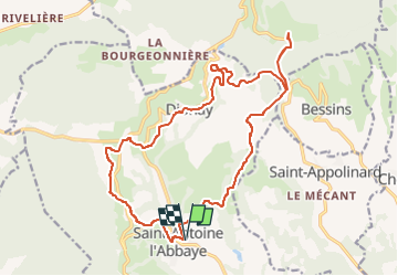
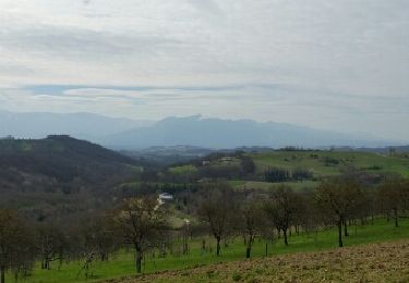
Trail On foot of 21 km to be discovered at Auvergne-Rhône-Alpes, Isère, Saint-Antoine l'Abbaye. This trail is proposed by JacouBrijou.
Description
Randonnée au départ de Saint Antoine l'Abbaye.
le tracé rejoint l'ancienne voie du TRAM Lyon - St Marcellin.
Au lieu "Chapelle de Rodon" possibilité d'effectuer un A/R pour aller admirer l'abbaye ND de Chambaran.
Positioning
Country:
France
Region :
Auvergne-Rhône-Alpes
Department/Province :
Isère
Municipality :
Saint-Antoine l'Abbaye
Location:
Saint-Antoine-l'Abbaye
Start:(Dec)
Start:(UTM)
674392 ; 5004730 (31T) N.
Comments
Trails nearby
![Trail Mountain bike Chatte - De Chatte à St Antoine en passant par Chevrière - Photo](https://media.geolcdn.com/t/375/260/ext.jpg?maxdim=2&url=https%3A%2F%2Fstatic1.geolcdn.com%2Fsiteimages%2Fupload%2Ffiles%2F1524743154velo.jpg)
![Mountain bike Mountain bike](https://static1.geolcdn.com/sitytour/trail-icons/202.png)
De Chatte à St Antoine en passant par Chevrière
Mountain bike
Very difficult
(1)
Chatte,
Auvergne-Rhône-Alpes,
Isère,
France
![](/images/other/stat-length.png)
44 km | 60 km-effort
3h 53min
![](https://static1.geolcdn.com/siteimages/upload/files/16400158638029165_repeat_loop_refresh_sync_direction_icon.png)
Yes
![Trail Walking Saint-Antoine l'Abbaye - saint Antoine l abbaye - Photo](https://media.geolcdn.com/t/375/260/ext.jpg?maxdim=2&url=https%3A%2F%2Fstatic1.geolcdn.com%2Fsiteimages%2Fupload%2Ffiles%2F1553511878bg_sport_marche.png)
![Walking Walking](https://static1.geolcdn.com/sitytour/trail-icons/101.png)
saint Antoine l abbaye
Walking
Very easy
(1)
Saint-Antoine l'Abbaye,
Auvergne-Rhône-Alpes,
Isère,
France
![](/images/other/stat-length.png)
6.9 km | 9.3 km-effort
1h 52min
![](https://static1.geolcdn.com/siteimages/upload/files/16400158638029165_repeat_loop_refresh_sync_direction_icon.png)
Yes
![Trail Walking Saint-Antoine l'Abbaye - Départ Dionay circuit à St Antoine l'abbaye - Photo](https://media.geolcdn.com/t/375/260/5f2ac104-ff74-4101-85da-1bb62e200fdc.jpg&format=jpg&maxdim=2)
![Walking Walking](https://static1.geolcdn.com/sitytour/trail-icons/101.png)
Départ Dionay circuit à St Antoine l'abbaye
Walking
Very difficult
Saint-Antoine l'Abbaye,
Auvergne-Rhône-Alpes,
Isère,
France
![](/images/other/stat-length.png)
18.3 km | 25 km-effort
4h 11min
![](https://static1.geolcdn.com/siteimages/upload/files/16400158638029165_repeat_loop_refresh_sync_direction_icon.png)
Yes
![Trail Walking Roybon - Dionay - Photo](https://media.geolcdn.com/t/375/260/8b746741-3496-4ce2-91f1-c91c1779e6d7.jpg&format=jpg&maxdim=2)
![Walking Walking](https://static1.geolcdn.com/sitytour/trail-icons/101.png)
Dionay
Walking
Difficult
Roybon,
Auvergne-Rhône-Alpes,
Isère,
France
![](/images/other/stat-length.png)
9.6 km | 12.1 km-effort
1h 54min
![](https://static1.geolcdn.com/siteimages/upload/files/16400158638029165_repeat_loop_refresh_sync_direction_icon.png)
Yes
![Trail Mountain bike Chatte - chemin du tram part1 - Photo](https://media.geolcdn.com/t/375/260/4b96f262-5eb3-483c-bd05-b1126f93c437.jpg&format=jpg&maxdim=2)
![Mountain bike Mountain bike](https://static1.geolcdn.com/sitytour/trail-icons/202.png)
chemin du tram part1
Mountain bike
Very easy
Chatte,
Auvergne-Rhône-Alpes,
Isère,
France
![](/images/other/stat-length.png)
11.4 km | 14.1 km-effort
1h 16min
![](https://static1.geolcdn.com/siteimages/upload/files/16400158638029165_repeat_loop_refresh_sync_direction_icon.png)
Yes
![Trail Walking Saint-Antoine l'Abbaye - st. Antoine l'Abbaye - Photo](https://media.geolcdn.com/t/375/260/ext.jpg?maxdim=2&url=https%3A%2F%2Fservices.sitytrail.com%2FGeolivesWS%2FDownloadMedia.ashx%3FTrailID%3D673116%26Media%3Dfix__20161215092710.jpg)
![Walking Walking](https://static1.geolcdn.com/sitytour/trail-icons/101.png)
st. Antoine l'Abbaye
Walking
Easy
Saint-Antoine l'Abbaye,
Auvergne-Rhône-Alpes,
Isère,
France
![](/images/other/stat-length.png)
21 km | 28 km-effort
5h 36min
![](https://static1.geolcdn.com/siteimages/upload/files/16400158638029165_repeat_loop_refresh_sync_direction_icon.png)
Yes
![Trail Walking Saint-Antoine l'Abbaye - cap'r à Dionay - Photo](https://media.geolcdn.com/t/375/260/ext.jpg?maxdim=2&url=https%3A%2F%2Fservices.sitytrail.com%2FGeolivesWS%2FDownloadMedia.ashx%3FTrailID%3D404513%26Media%3Dfix__20150328102558.jpg)
![Walking Walking](https://static1.geolcdn.com/sitytour/trail-icons/101.png)
cap'r à Dionay
Walking
Easy
Saint-Antoine l'Abbaye,
Auvergne-Rhône-Alpes,
Isère,
France
![](/images/other/stat-length.png)
8.7 km | 11.4 km-effort
1h 16min
![](https://static1.geolcdn.com/siteimages/upload/files/16400158638029165_repeat_loop_refresh_sync_direction_icon.png)
Yes
![Trail Mountain bike Chatte - grp st Marcellin st Antoine - Photo](https://media.geolcdn.com/t/375/260/ext.jpg?maxdim=2&url=https%3A%2F%2Fstatic1.geolcdn.com%2Fsiteimages%2Fupload%2Ffiles%2F1524743154velo.jpg)
![Mountain bike Mountain bike](https://static1.geolcdn.com/sitytour/trail-icons/202.png)
grp st Marcellin st Antoine
Mountain bike
Very difficult
Chatte,
Auvergne-Rhône-Alpes,
Isère,
France
![](/images/other/stat-length.png)
99 km | 133 km-effort
9h 12min
![](https://static1.geolcdn.com/siteimages/upload/files/16400158638029165_repeat_loop_refresh_sync_direction_icon.png)
No
![Trail Walking Saint-Antoine l'Abbaye - Lac Chapaize / St Antoine - Photo](https://media.geolcdn.com/t/375/260/ext.jpg?maxdim=2&url=https%3A%2F%2Fstatic1.geolcdn.com%2Fsiteimages%2Fupload%2Ffiles%2F1553511878bg_sport_marche.png)
![Walking Walking](https://static1.geolcdn.com/sitytour/trail-icons/101.png)
Lac Chapaize / St Antoine
Walking
Medium
Saint-Antoine l'Abbaye,
Auvergne-Rhône-Alpes,
Isère,
France
![](/images/other/stat-length.png)
7.1 km | 9.4 km-effort
2h 7min
![](https://static1.geolcdn.com/siteimages/upload/files/16400158638029165_repeat_loop_refresh_sync_direction_icon.png)
Yes