![](/images/other/stat-length.png)
![Trail Electric bike Le Lavandou - Aiguebelle St Tropez (AR) (25 10 2022) - Photo](https://media.geolcdn.com/t/1900/400/ext.pjpeg?maxdim=2&url=https%3A%2F%2Fstatic1.geolcdn.com%2Fsiteimages%2Fupload%2Ffiles%2F1524743154velo.jpg)
Aiguebelle St Tropez (AR) (25 10 2022)
Hugues Michel
User
![Length](/images/other/stat-length.png)
Length
66 km
![Max alt](https://static1.geolcdn.com/siteimages/upload/files/1508320355ic_sort_altitude_max_24dp.png)
Max alt
116 m
![Uphill gradient](https://static1.geolcdn.com/siteimages/upload/files/1508320355ic_sort_den_pos_24dp.png)
Uphill gradient
882 m
![Km-Effort](/images/other/stat-length.png)
Km-Effort
78 km
![Min alt](https://static1.geolcdn.com/siteimages/upload/files/1508320355ic_sort_altitude_min_24dp.png)
Min alt
0 m
![Downhill gradient](https://static1.geolcdn.com/siteimages/upload/files/1508320355ic_sort_den_neg_24dp.png)
Downhill gradient
881 m
![Boucle](https://static1.geolcdn.com/siteimages/upload/files/16400158638029165_repeat_loop_refresh_sync_direction_icon.png)
Boucle
Yes
Creation date :
2022-10-25 07:58:40.273
Updated on :
2024-11-11 10:10:33.849
![Electric bike](https://static1.geolcdn.com/sitytour/trail-icons/205.png)
4h11
Difficulty : Easy
![Scan this QR Code to open this trail in the SityTrail application](https://capi.geolives.com/qq0zvz2zws4bq2lad0pu/sitytour/trails/3435074/qr.png?size=200)
FREE GPS app for hiking
About
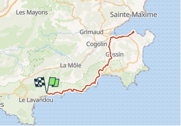
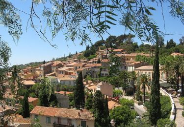
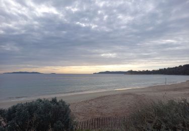
Trail Electric bike of 66 km to be discovered at Provence-Alpes-Côte d'Azur, Var, Le Lavandou. This trail is proposed by Hugues Michel.
Description
Balade sympa sur la piste cyclable du littoral, pas de difficulté, si ce n'est les 66km. Piste peu ou pas visible à proximité de St Tropez, mais rien de rédhibitoire.
Positioning
Country:
France
Region :
Provence-Alpes-Côte d'Azur
Department/Province :
Var
Municipality :
Le Lavandou
Location:
Unknown
Start:(Dec)
Start:(UTM)
288698 ; 4780868 (32T) N.
Comments
Trails nearby
![Trail Walking Bormes-les-Mimosas - SityTrail - Bormes les Mimosas - ND de Constance - Cols de Gratteloup et Landon - Photo](https://media.geolcdn.com/t/375/260/c3cd69d2-66a0-450a-95c5-e8005107dd21.jpg&format=jpg&maxdim=2)
![Walking Walking](https://static1.geolcdn.com/sitytour/trail-icons/101.png)
SityTrail - Bormes les Mimosas - ND de Constance - Cols de Gratteloup et Landon
Walking
Difficult
(1)
Bormes-les-Mimosas,
Provence-Alpes-Côte d'Azur,
Var,
France
![](/images/other/stat-length.png)
13.4 km | 21 km-effort
5h 48min
![](https://static1.geolcdn.com/siteimages/upload/files/16400158638029165_repeat_loop_refresh_sync_direction_icon.png)
Yes
![Trail Walking Bormes-les-Mimosas - SityTrail - 3043274 - bargeanxchartreuse-verne - Photo](https://media.geolcdn.com/t/375/260/3db88ff5-5d2e-4949-8a29-14c430fd8c8f.jpg&format=jpg&maxdim=2)
![Walking Walking](https://static1.geolcdn.com/sitytour/trail-icons/101.png)
SityTrail - 3043274 - bargeanxchartreuse-verne
Walking
Medium
(2)
Bormes-les-Mimosas,
Provence-Alpes-Côte d'Azur,
Var,
France
![](/images/other/stat-length.png)
15.2 km | 23 km-effort
6h 0min
![](https://static1.geolcdn.com/siteimages/upload/files/16400158638029165_repeat_loop_refresh_sync_direction_icon.png)
Yes
![Trail Walking Bormes-les-Mimosas - Chartreuse de la Verne - Photo](https://media.geolcdn.com/t/375/260/ext.jpg?maxdim=2&url=https%3A%2F%2Fservices.sitytrail.com%2FGeolivesWS%2FDownloadMedia.ashx%3FTrailID%3D898630%26Media%3Dfix__20170215102107.jpg)
![Walking Walking](https://static1.geolcdn.com/sitytour/trail-icons/101.png)
Chartreuse de la Verne
Walking
Difficult
(2)
Bormes-les-Mimosas,
Provence-Alpes-Côte d'Azur,
Var,
France
![](/images/other/stat-length.png)
19.3 km | 31 km-effort
6h 26min
![](https://static1.geolcdn.com/siteimages/upload/files/16400158638029165_repeat_loop_refresh_sync_direction_icon.png)
Yes
![Trail Walking Le Lavandou - Du Lavandou à la Pointe de l'Esquillette - Photo](https://media.geolcdn.com/t/375/260/ext.jpg?maxdim=2&url=https%3A%2F%2Fservices.sitytrail.com%2FGeolivesWS%2FDownloadMedia.ashx%3FTrailID%3D105657%26Media%3D9466_6.jpg)
![Walking Walking](https://static1.geolcdn.com/sitytour/trail-icons/101.png)
Du Lavandou à la Pointe de l'Esquillette
Walking
Easy
(1)
Le Lavandou,
Provence-Alpes-Côte d'Azur,
Var,
France
![](/images/other/stat-length.png)
5.9 km | 7.2 km-effort
3h 0min
![](https://static1.geolcdn.com/siteimages/upload/files/16400158638029165_repeat_loop_refresh_sync_direction_icon.png)
No
![Trail Walking Bormes-les-Mimosas - Bormes les Mimosas et la Forêt des Maures - Photo](https://media.geolcdn.com/t/375/260/ext.jpg?maxdim=2&url=https%3A%2F%2Fservices.sitytrail.com%2FGeolivesWS%2FDownloadMedia.ashx%3FTrailID%3D103786%26Media%3D6556_2.jpg)
![Walking Walking](https://static1.geolcdn.com/sitytour/trail-icons/101.png)
Bormes les Mimosas et la Forêt des Maures
Walking
Medium
(2)
Bormes-les-Mimosas,
Provence-Alpes-Côte d'Azur,
Var,
France
![](/images/other/stat-length.png)
14 km | 22 km-effort
4h 15min
![](https://static1.geolcdn.com/siteimages/upload/files/16400158638029165_repeat_loop_refresh_sync_direction_icon.png)
Yes
![Trail Walking Le Lavandou - Balcons de Pramousquier 22.1.23 - Photo](https://media.geolcdn.com/t/375/260/b49f05a7-2e02-450b-a614-7cc169048d9c.jpg&format=jpg&maxdim=2)
![Walking Walking](https://static1.geolcdn.com/sitytour/trail-icons/101.png)
Balcons de Pramousquier 22.1.23
Walking
Medium
Le Lavandou,
Provence-Alpes-Côte d'Azur,
Var,
France
![](/images/other/stat-length.png)
12.3 km | 19.2 km-effort
4h 0min
![](https://static1.geolcdn.com/siteimages/upload/files/16400158638029165_repeat_loop_refresh_sync_direction_icon.png)
Yes
![Trail Walking Bormes-les-Mimosas - Bormes les Mimosas Les 3 Cols - Photo](https://media.geolcdn.com/t/375/260/23bdb278-92e8-4d98-83cb-eb5b5435fc48.jpg&format=jpg&maxdim=2)
![Walking Walking](https://static1.geolcdn.com/sitytour/trail-icons/101.png)
Bormes les Mimosas Les 3 Cols
Walking
Very difficult
Bormes-les-Mimosas,
Provence-Alpes-Côte d'Azur,
Var,
France
![](/images/other/stat-length.png)
16.5 km | 26 km-effort
4h 41min
![](https://static1.geolcdn.com/siteimages/upload/files/16400158638029165_repeat_loop_refresh_sync_direction_icon.png)
Yes
![Trail Walking Bormes-les-Mimosas - Boucle : Pont des Caunes - Piste de l'Amandier - Piste de la Gourre - Piste Lambert - Col de la Citadelle - Pont des Caunes. - Photo](https://media.geolcdn.com/t/375/260/93e7f835-4806-4284-8793-c12d2410b0fc.jpg&format=jpg&maxdim=2)
![Walking Walking](https://static1.geolcdn.com/sitytour/trail-icons/101.png)
Boucle : Pont des Caunes - Piste de l'Amandier - Piste de la Gourre - Piste L...
Walking
Medium
Bormes-les-Mimosas,
Provence-Alpes-Côte d'Azur,
Var,
France
![](/images/other/stat-length.png)
15.1 km | 21 km-effort
5h 6min
![](https://static1.geolcdn.com/siteimages/upload/files/16400158638029165_repeat_loop_refresh_sync_direction_icon.png)
Yes
![Trail Walking Le Lavandou - cavaliere - Photo](https://media.geolcdn.com/t/375/260/ext.jpg?maxdim=2&url=https%3A%2F%2Fstatic1.geolcdn.com%2Fsiteimages%2Fupload%2Ffiles%2F1553511878bg_sport_marche.png)
![Walking Walking](https://static1.geolcdn.com/sitytour/trail-icons/101.png)
cavaliere
Walking
Medium
(1)
Le Lavandou,
Provence-Alpes-Côte d'Azur,
Var,
France
![](/images/other/stat-length.png)
17.8 km | 28 km-effort
6h 59min
![](https://static1.geolcdn.com/siteimages/upload/files/16400158638029165_repeat_loop_refresh_sync_direction_icon.png)
Yes