Trail Walking Saint-Martin-en-Vercors - Circuit plateau du Vercors - Photo
© OpenStreetMap contributors
Length
Length
12.7 km
Max alt
Max alt
1449 m
Uphill gradient
Uphill gradient
272 m
Km-Effort
Km-Effort  
16.3 km
Min alt
Min alt
1298 m
Downhill gradient
Downhill gradient
276 m
Boucle
Boucle
Yes
Creation date :
2014-12-10 00:00:00.0
Updated on :
2014-12-10 00:00:00.0

(0 Reviews)

Walking
Walking
3h18
Difficulty : Easy

Scan this QR Code to open this trail in the SityTrail application

FREE GPS app for hiking

Logo SityTrail SityTrail

IGN / Geographical institutes

Download SityTrail from the App Store Download SityTrail from Google Play

Logo SityTrail SityTrail World

The world is yours!

Download SityTrail from the App Store Download SityTrail from Google Play Download SityTrail on Huawei AppGallery

About

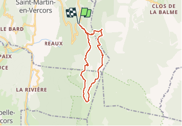
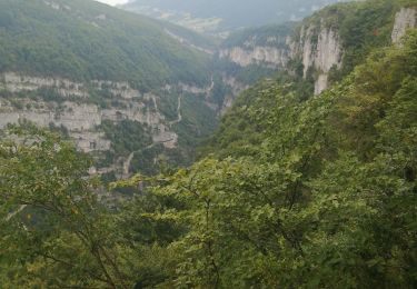
Trail Walking of 12.7 km to be discovered at Auvergne-Rhône-Alpes, Drôme, Saint-Martin-en-Vercors. This trail is proposed by olivier26.

Description

cette rando peut s'effectuer en famille sans aucun problème. Le circuit alterne sous bois et pelouse des hauts plateaux du Vercors.

Elevation profile

Positioning

Country:
France
Region :
Auvergne-Rhône-Alpes
Department/Province :
Drôme
Municipality :
Saint-Martin-en-Vercors
Location:
Unknown
Start:(UTM)
694826 ; 4987366 (31T) N.

Trails nearby

Trail Walking La Chapelle-en-Vercors - Belvedere de la Révoulat - Photo
Walking
simon.paume

Walking

Easy
(1)
La Chapelle-en-Vercors, Auvergne-Rhône-Alpes, Drôme, France
5.3 km | 10.6 km-effort
2h 5min
Yes
Trail Mountain bike Corrençon-en-Vercors - Grande Traversée des PréAlpes à VTT : Corrençon en Vercors - La Chapelle en Vercors - Photo
Mountain bike
tracegps

Mountain bike

Difficult
(1)
Corrençon-en-Vercors, Auvergne-Rhône-Alpes, Isère, France
25 km | 36 km-effort
3h 30min
No
Trail Walking Corrençon-en-Vercors - 38 tête chaudière  - Photo
Walking
GUIDE
randodyssée

Walking

Medium
Corrençon-en-Vercors, Auvergne-Rhône-Alpes, Isère, France
10.8 km | 22 km-effort
7h 3min
Yes
Trail Touring skiing Corrençon-en-Vercors - tête chaudière et petite moucherolle - Photo
Touring skiing
GUIDE
nadd73

Touring skiing

Easy
Corrençon-en-Vercors, Auvergne-Rhône-Alpes, Isère, France
11.9 km | 27 km-effort
5h 1min
Yes
Trail Other activity Saint-Martin-en-Vercors - Cournouses pas de l'allier - Photo
Other activity
collot

Other activity

Medium
(1)
Saint-Martin-en-Vercors, Auvergne-Rhône-Alpes, Drôme, France
11 km | 21 km-effort
5h 0min
Yes
Trail Walking Saint-Julien-en-Vercors - le pont du diable - Photo
Walking
Vero7684

Walking

Medium
Saint-Julien-en-Vercors, Auvergne-Rhône-Alpes, Drôme, France
5.4 km | 8.4 km-effort
2h 14min
Yes
Trail Walking Corrençon-en-Vercors - Correncon  - Photo
Walking
ajd26

Walking

Very difficult
Corrençon-en-Vercors, Auvergne-Rhône-Alpes, Isère, France
19 km | 37 km-effort
6h 30min
Yes
Trail sport Corrençon-en-Vercors - Corrençon en Vercors  - Photo
sport
alinetpierre

sport

Very easy
Corrençon-en-Vercors, Auvergne-Rhône-Alpes, Isère, France
10.7 km | 14.1 km-effort
Unknown
Yes
Trail Walking Corrençon-en-Vercors - balladecavec les copines - Photo
Walking
gerinmaryse

Walking

Medium
Corrençon-en-Vercors, Auvergne-Rhône-Alpes, Isère, France
8.6 km | 11.8 km-effort
3h 33min
Yes


Close
My subscriptions