![](/images/other/stat-length.png)
![Trail Mountain bike Aachen - Eu.AachenVerviers67D58km693m+VTC - Photo](https://media.geolcdn.com/t/1900/400/ext.pjpeg?maxdim=2&url=https%3A%2F%2Fstatic1.geolcdn.com%2Fsiteimages%2Fupload%2Ffiles%2F1524743154velo.jpg)
Eu.AachenVerviers67D58km693m+VTC
francois58
User
![Length](/images/other/stat-length.png)
Length
59 km
![Max alt](https://static1.geolcdn.com/siteimages/upload/files/1508320355ic_sort_altitude_max_24dp.png)
Max alt
422 m
![Uphill gradient](https://static1.geolcdn.com/siteimages/upload/files/1508320355ic_sort_den_pos_24dp.png)
Uphill gradient
807 m
![Km-Effort](/images/other/stat-length.png)
Km-Effort
70 km
![Min alt](https://static1.geolcdn.com/siteimages/upload/files/1508320355ic_sort_altitude_min_24dp.png)
Min alt
165 m
![Downhill gradient](https://static1.geolcdn.com/siteimages/upload/files/1508320355ic_sort_den_neg_24dp.png)
Downhill gradient
845 m
![Boucle](https://static1.geolcdn.com/siteimages/upload/files/16400158638029165_repeat_loop_refresh_sync_direction_icon.png)
Boucle
No
Creation date :
2017-06-21 00:00:00.0
Updated on :
2017-06-21 00:00:00.0
![Mountain bike](https://static1.geolcdn.com/sitytour/trail-icons/202.png)
4h33
Difficulty : Medium
![Scan this QR Code to open this trail in the SityTrail application](https://capi.geolives.com/qq0zvz2zws4bq2lad0pu/sitytour/trails/343140/qr.png?size=200)
FREE GPS app for hiking
About
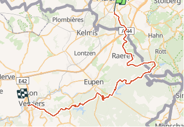
Trail Mountain bike of 59 km to be discovered at North Rhine-Westphalia, Städteregion Aachen, Aachen. This trail is proposed by francois58.
Description
Itinéraire VTC forestier en Eurégio joignant Aachen et Verviers via les lacs d'Eupen et de la Gileppe
Randonnée Elèves 2013 J4/4
Positioning
Country:
Germany
Region :
North Rhine-Westphalia
Department/Province :
Städteregion Aachen
Municipality :
Aachen
Location:
Aachen-Mitte
Start:(Dec)
Start:(UTM)
294433 ; 5626305 (32U) N.
Comments
Trails nearby
![Trail Walking Raeren - 2023-09-21_15h54m11_392.gpx.xml - Photo](https://media.geolcdn.com/t/375/260/ext.jpg?maxdim=2&url=https%3A%2F%2Fmedia.geolcdn.com%2Ff%2F3a31813f-998d-4148-baa8-502439fc02b8.jpg)
![Walking Walking](https://static1.geolcdn.com/sitytour/trail-icons/101.png)
2023-09-21_15h54m11_392.gpx.xml
Walking
Medium
(1)
Raeren,
Wallonia,
Liège,
Belgium
![](/images/other/stat-length.png)
13.2 km | 17.3 km-effort
3h 55min
![](https://static1.geolcdn.com/siteimages/upload/files/16400158638029165_repeat_loop_refresh_sync_direction_icon.png)
Yes
![Trail Walking Aachen - Aix-la-Chapelle - Photo](https://media.geolcdn.com/t/375/260/ext.jpg?maxdim=2&url=https%3A%2F%2Fmedia.geolcdn.com%2Ff%2F19678e47-68ef-4997-bad3-67eb75fafd82.jpg)
![Walking Walking](https://static1.geolcdn.com/sitytour/trail-icons/101.png)
Aix-la-Chapelle
Walking
Easy
(1)
Aachen,
North Rhine-Westphalia,
Städteregion Aachen,
Germany
![](/images/other/stat-length.png)
11.4 km | 15.4 km-effort
3h 30min
![](https://static1.geolcdn.com/siteimages/upload/files/16400158638029165_repeat_loop_refresh_sync_direction_icon.png)
Yes
![Trail Walking Aachen - Aix-la-Chapelle - Photo](https://media.geolcdn.com/t/375/260/ext.jpg?maxdim=2&url=https%3A%2F%2Fmedia.geolcdn.com%2Ff%2Fefbe95f3-eeed-42aa-9acc-74aad4d18b78.jpg)
![Walking Walking](https://static1.geolcdn.com/sitytour/trail-icons/101.png)
Aix-la-Chapelle
Walking
Easy
(1)
Aachen,
North Rhine-Westphalia,
Städteregion Aachen,
Germany
![](/images/other/stat-length.png)
11.1 km | 13.4 km-effort
3h 2min
![](https://static1.geolcdn.com/siteimages/upload/files/16400158638029165_repeat_loop_refresh_sync_direction_icon.png)
Yes
![Trail Walking Raeren - 2022-01-18_14h11m36_lichtenbusch - Photo](https://media.geolcdn.com/t/375/260/ext.jpg?maxdim=2&url=https%3A%2F%2Fmedia.geolcdn.com%2Ff%2F83311396-e126-40d9-b822-9da5f0d28323.jpg)
![Walking Walking](https://static1.geolcdn.com/sitytour/trail-icons/101.png)
2022-01-18_14h11m36_lichtenbusch
Walking
Easy
(2)
Raeren,
Wallonia,
Liège,
Belgium
![](/images/other/stat-length.png)
14.8 km | 17 km-effort
3h 52min
![](https://static1.geolcdn.com/siteimages/upload/files/16400158638029165_repeat_loop_refresh_sync_direction_icon.png)
Yes
![Trail Walking Raeren - 2021-04-02_18h39m41_975 - Photo](https://media.geolcdn.com/t/375/260/ext.jpg?maxdim=2&url=https%3A%2F%2Fmedia.geolcdn.com%2Ff%2F4dbde2fb-33e3-4e75-84b3-1404a45e04cc.jpg)
![Walking Walking](https://static1.geolcdn.com/sitytour/trail-icons/101.png)
2021-04-02_18h39m41_975
Walking
Easy
(1)
Raeren,
Wallonia,
Liège,
Belgium
![](/images/other/stat-length.png)
14.6 km | 17.8 km-effort
4h 2min
![](https://static1.geolcdn.com/siteimages/upload/files/16400158638029165_repeat_loop_refresh_sync_direction_icon.png)
Yes
![Trail Walking Kelmis - 20200730 - Les 3 Bornes 7.3 Km - Photo](https://media.geolcdn.com/t/375/260/ext.jpg?maxdim=2&url=https%3A%2F%2Fmedia.geolcdn.com%2Ff%2Fab7b3f98-4235-4a73-ba70-1bedd5c785f3.jpg)
![Walking Walking](https://static1.geolcdn.com/sitytour/trail-icons/101.png)
20200730 - Les 3 Bornes 7.3 Km
Walking
Difficult
(1)
Kelmis,
Wallonia,
Liège,
Belgium
![](/images/other/stat-length.png)
7.4 km | 10.4 km-effort
1h 50min
![](https://static1.geolcdn.com/siteimages/upload/files/16400158638029165_repeat_loop_refresh_sync_direction_icon.png)
Yes
![Trail Walking Kelmis - Venn Trilogie (1er étape) - Photo](https://media.geolcdn.com/t/375/260/ext.jpg?maxdim=2&url=https%3A%2F%2Fmedia.geolcdn.com%2Ff%2F1309a595-2e15-4d31-9259-ac0f30e3e1c8.jpg)
![Walking Walking](https://static1.geolcdn.com/sitytour/trail-icons/101.png)
Venn Trilogie (1er étape)
Walking
Medium
(1)
Kelmis,
Wallonia,
Liège,
Belgium
![](/images/other/stat-length.png)
25 km | 30 km-effort
5h 0min
![](https://static1.geolcdn.com/siteimages/upload/files/16400158638029165_repeat_loop_refresh_sync_direction_icon.png)
No
![Trail Walking Raeren - RB-Lg-30_Hauset_via-racc-2 - Photo](https://media.geolcdn.com/t/375/260/ext.jpg?maxdim=2&url=https%3A%2F%2Fservices.sitytrail.com%2FGeolivesWS%2FDownloadMedia.ashx%3FTrailID%3D402105%26Media%3Df4d2b2db-afd2-4d70-8342-c9642a40cdea.jpg)
![Walking Walking](https://static1.geolcdn.com/sitytour/trail-icons/101.png)
RB-Lg-30_Hauset_via-racc-2
Walking
(3)
Raeren,
Wallonia,
Liège,
Belgium
![](/images/other/stat-length.png)
13.3 km | 15.9 km-effort
3h 37min
![](https://static1.geolcdn.com/siteimages/upload/files/16400158638029165_repeat_loop_refresh_sync_direction_icon.png)
Yes
![Trail Walking Raeren - RB-Lg-30_Hauset - Photo](https://media.geolcdn.com/t/375/260/ext.jpg?maxdim=2&url=https%3A%2F%2Fservices.sitytrail.com%2FGeolivesWS%2FDownloadMedia.ashx%3FTrailID%3D402103%26Media%3Df4d2b2db-afd2-4d70-8342-c9642a40cdea.jpg)
![Walking Walking](https://static1.geolcdn.com/sitytour/trail-icons/101.png)