Trail Walking Saint-Raphaël - SityTrail - z les ferrières 18-1022 - Photo

SityTrail - z les ferrières 18-1022

© OpenStreetMap contributors
Length
Length
5.8 km
Max alt
Max alt
106 m
Uphill gradient
Uphill gradient
130 m
Km-Effort
Km-Effort  
7.5 km
Min alt
Min alt
6 m
Downhill gradient
Downhill gradient
130 m
Boucle
Boucle
Yes
Creation date :
2022-10-19 06:28:24.451
Updated on :
2022-10-19 06:28:59.984

(0 Reviews)

Walking
Walking
1h42
Difficulty : Medium

Scan this QR Code to open this trail in the SityTrail application

FREE GPS app for hiking

Logo SityTrail SityTrail

IGN / Geographical institutes

Download SityTrail from the App Store Download SityTrail from Google Play

Logo SityTrail SityTrail World

The world is yours!

Download SityTrail from the App Store Download SityTrail from Google Play Download SityTrail on Huawei AppGallery

About

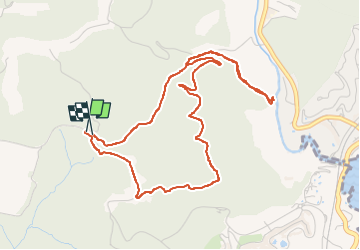
Trail Walking of 5.8 km to be discovered at Provence-Alpes-Côte d'Azur, Var, Saint-Raphaël. This trail is proposed by marcheetnature.

Description

1ère partie de la rando par des sentiers très agréables et la plupart du temps ombragés ;retour, après les rives de l'Agay" ,par une bonne montée sur une route défoncée

Elevation profile

Positioning

Country:
France
Region :
Provence-Alpes-Côte d'Azur
Department/Province :
Var
Municipality :
Saint-Raphaël
Location:
Unknown
Start:(UTM)
324766 ; 4811275 (32T) N.

Trails nearby

Trail Walking Saint-Raphaël - Les lacs par les rochers du Caneiret - Photo
Walking
ETMU5496

Walking

Medium
(1)
Saint-Raphaël, Provence-Alpes-Côte d'Azur, Var, France
20 km | 29 km-effort
5h 7min
Yes
Trail Mountain bike Fréjus - grand tour esterel par belles pistes larges - Photo
Mountain bike
Margaide

Mountain bike

Easy
(2)
Fréjus, Provence-Alpes-Côte d'Azur, Var, France
31 km | 40 km-effort
3h 17min
Yes
Trail Walking Saint-Raphaël - Agay - Sainte-Barbe - Étang des Nénuphares - Photo
Walking
E.BURCK

Walking

Easy
(2)
Saint-Raphaël, Provence-Alpes-Côte d'Azur, Var, France
5 km | 6.2 km-effort
2h 8min
Yes
Trail Walking Fréjus - Mont Vinaigre par Colle Douce - Photo
Walking

Walking

Very difficult
(1)
Fréjus, Provence-Alpes-Côte d'Azur, Var, France
22 km | 33 km-effort
6h 1min
Yes
Trail Walking Saint-Raphaël - Esterel Trace réelle - Photo
Walking
GUIDE
jouans

Walking

Very difficult
Saint-Raphaël, Provence-Alpes-Côte d'Azur, Var, France
21 km | 32 km-effort
7h 11min
Yes
Trail Walking Fréjus - Sortie du lundi 8 janvier aprés-midi - Photo
Walking
OB83700

Walking

Medium
(1)
Fréjus, Provence-Alpes-Côte d'Azur, Var, France
7.4 km | 10.7 km-effort
2h 50min
Yes
Trail Mountain bike Saint-Raphaël - activity_9094673788 - Photo
Mountain bike
GUIDE
pascalou73

Mountain bike

Medium
Saint-Raphaël, Provence-Alpes-Côte d'Azur, Var, France
19.6 km | 25 km-effort
1h 42min
Yes
Trail Mountain bike Saint-Raphaël - activity_9094242808 - Photo
Mountain bike
GUIDE
pascalou73

Mountain bike

Medium
Saint-Raphaël, Provence-Alpes-Côte d'Azur, Var, France
22 km | 29 km-effort
1h 59min
Yes
Trail Mountain bike Saint-Raphaël - activity_9082592241 - Photo
Mountain bike
GUIDE
pascalou73

Mountain bike

Very difficult
Saint-Raphaël, Provence-Alpes-Côte d'Azur, Var, France
34 km | 45 km-effort
3h 6min
Yes


Close
My subscriptions