Trail Walking La Ciotat - st fretouse le semaphore belvédère la  route des crêtes  - Photo

st fretouse le semaphore belvédère la route des crêtes

 ego
ego

User

© OpenStreetMap contributors
Length
Length
7.2 km
Max alt
Max alt
380 m
Uphill gradient
Uphill gradient
343 m
Km-Effort
Km-Effort  
11.8 km
Min alt
Min alt
104 m
Downhill gradient
Downhill gradient
346 m
Boucle
Boucle
Yes
Creation date :
2022-10-18 09:46:03.238
Updated on :
2022-10-28 16:07:24.378

(0 Reviews)

Walking
Walking
3h01
Difficulty : Medium

Scan this QR Code to open this trail in the SityTrail application

FREE GPS app for hiking

Logo SityTrail SityTrail

IGN / Geographical institutes

Download SityTrail from the App Store Download SityTrail from Google Play

Logo SityTrail SityTrail World

The world is yours!

Download SityTrail from the App Store Download SityTrail from Google Play Download SityTrail on Huawei AppGallery

About

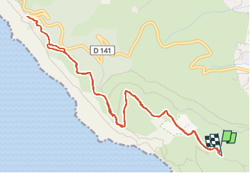
Trail Walking of 7.2 km to be discovered at Provence-Alpes-Côte d'Azur, Bouches-du-Rhône, La Ciotat. This trail is proposed by ego .

Description

montée par le chemin du sémaphore,( petite route goudronnée , qui finit en cul de sac ), là continuer par la piste Jaune (l'ancien chemin de la Vigie jusqu'au sémaphore , il y a de nombreuses variantes  pour monter,  
promenade  très facile   , très belle

Elevation profile

Photos

Positioning

Country:
France
Region :
Provence-Alpes-Côte d'Azur
Department/Province :
Bouches-du-Rhône
Municipality :
La Ciotat
Location:
Unknown
Start:(UTM)
710300 ; 4783158 (31T) N.

Trails nearby

Trail Road bike Cassis - 7909608-TRIMRS2017_Parcours Bike L V5 - Photo
Road bike
GUIDE+

Road bike

Medium
(1)
Cassis, Provence-Alpes-Côte d'Azur, Bouches-du-Rhône, France
21 km | 26 km-effort
1h 31min
No
Trail Walking La Ciotat - Rando Ciotat - Photo
Walking
GUIDE
affinetataille

Walking

Difficult
(1)
La Ciotat, Provence-Alpes-Côte d'Azur, Bouches-du-Rhône, France
12.1 km | 19.9 km-effort
7h 30min
Yes
Trail Walking La Ciotat - la ciotat - Photo
Walking
Berrangerannick

Walking

Very easy
(1)
La Ciotat, Provence-Alpes-Côte d'Azur, Bouches-du-Rhône, France
6.2 km | 9.3 km-effort
3h 21min
Yes
Trail Walking Cassis - les calanques de Cassis - Photo
Walking
th.feur

Walking

Medium
(1)
Cassis, Provence-Alpes-Côte d'Azur, Bouches-du-Rhône, France
15.9 km | 23 km-effort
6h 2min
No
Trail Walking Cassis - La Pointe Sud d'en Vau, depuis Cassis - Photo
Walking
tracegps

Walking

Medium
(2)
Cassis, Provence-Alpes-Côte d'Azur, Bouches-du-Rhône, France
7.7 km | 11.9 km-effort
3h 30min
Yes
Trail Walking La Ciotat - Balade La Ciotat  - Photo
Walking
BADEY

Walking

Difficult
(1)
La Ciotat, Provence-Alpes-Côte d'Azur, Bouches-du-Rhône, France
8.8 km | 14 km-effort
3h 7min
Yes
Trail Walking Cassis - calanques 1 - Photo
Walking
lionel4806

Walking

Difficult
(1)
Cassis, Provence-Alpes-Côte d'Azur, Bouches-du-Rhône, France
14.6 km | 26 km-effort
5h 37min
No
Trail Walking La Ciotat - Cap Canaille - Photo
Walking
DanielROLLET

Walking

Medium
(1)
La Ciotat, Provence-Alpes-Côte d'Azur, Bouches-du-Rhône, France
10.2 km | 16.2 km-effort
4h 0min
Yes
Trail Walking Cassis - MF La gardiole, En-Vau, Port-Pin, Port-Miou - Photo
Walking
DanielROLLET

Walking

Easy
(1)
Cassis, Provence-Alpes-Côte d'Azur, Bouches-du-Rhône, France
11.9 km | 18.3 km-effort
3h 54min
Yes


Close
My subscriptions