![](/images/other/stat-length.png)
![Trail Walking Saint-Restitut - 2022_10_16_CAF_St Restitut_Boucle du plateau - Photo](https://media.geolcdn.com/t/1900/400/ext.pjpeg?maxdim=2&url=https%3A%2F%2Fstatic1.geolcdn.com%2Fsiteimages%2Fupload%2Ffiles%2F1553511878bg_sport_marche.png)
2022_10_16_CAF_St Restitut_Boucle du plateau
Chamois30
User
![Length](/images/other/stat-length.png)
Length
15.3 km
![Max alt](https://static1.geolcdn.com/siteimages/upload/files/1508320355ic_sort_altitude_max_24dp.png)
Max alt
313 m
![Uphill gradient](https://static1.geolcdn.com/siteimages/upload/files/1508320355ic_sort_den_pos_24dp.png)
Uphill gradient
424 m
![Km-Effort](/images/other/stat-length.png)
Km-Effort
21 km
![Min alt](https://static1.geolcdn.com/siteimages/upload/files/1508320355ic_sort_altitude_min_24dp.png)
Min alt
90 m
![Downhill gradient](https://static1.geolcdn.com/siteimages/upload/files/1508320355ic_sort_den_neg_24dp.png)
Downhill gradient
423 m
![Boucle](https://static1.geolcdn.com/siteimages/upload/files/16400158638029165_repeat_loop_refresh_sync_direction_icon.png)
Boucle
Yes
Creation date :
2022-10-16 07:39:23.942
Updated on :
2022-10-16 17:36:51.709
![Walking](https://static1.geolcdn.com/sitytour/trail-icons/101.png)
4h38
Difficulty : Easy
![Scan this QR Code to open this trail in the SityTrail application](https://capi.geolives.com/qq0zvz2zws4bq2lad0pu/sitytour/trails/3426119/qr.png?size=200)
FREE GPS app for hiking
About
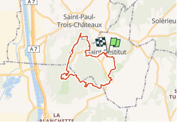
Trail Walking of 15.3 km to be discovered at Auvergne-Rhône-Alpes, Drôme, Saint-Restitut. This trail is proposed by Chamois30.
Description
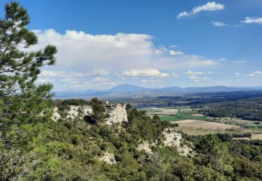
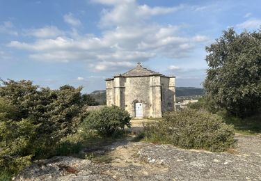
Boucle au départ de St Restitut qui fait le tour du plateau et permet de voir les châteaux de Chabrières et du Barry, les cave cathédrales (anciennes carrières souterraines) le village troglodyte, la chapelle St Juste et sa T.O. et le village de St Restitut.
Positioning
Country:
France
Region :
Auvergne-Rhône-Alpes
Department/Province :
Drôme
Municipality :
Saint-Restitut
Location:
Unknown
Start:(Dec)
Start:(UTM)
642787 ; 4910212 (31T) N.
Comments
Trails nearby
![Trail Walking Saint-Restitut - St Restitut Le Barry 12km - Photo](https://media.geolcdn.com/t/375/260/52d96bcf-650b-4fd0-a59a-69f2b2d3703d.jpg&format=jpg&maxdim=2)
![Walking Walking](https://static1.geolcdn.com/sitytour/trail-icons/101.png)
St Restitut Le Barry 12km
Walking
Medium
(1)
Saint-Restitut,
Auvergne-Rhône-Alpes,
Drôme,
France
![](/images/other/stat-length.png)
12.2 km | 15.9 km-effort
3h 37min
![](https://static1.geolcdn.com/siteimages/upload/files/16400158638029165_repeat_loop_refresh_sync_direction_icon.png)
Yes
![Trail Walking Bollène - Barry Chabrières Enclume 7,5km - Photo](https://media.geolcdn.com/t/375/260/3a4e67d1-088f-449d-b525-af6a45f2f0d7.jpg&format=jpg&maxdim=2)
![Walking Walking](https://static1.geolcdn.com/sitytour/trail-icons/101.png)
Barry Chabrières Enclume 7,5km
Walking
Medium
(1)
Bollène,
Provence-Alpes-Côte d'Azur,
Vaucluse,
France
![](/images/other/stat-length.png)
7.6 km | 10.1 km-effort
2h 30min
![](https://static1.geolcdn.com/siteimages/upload/files/16400158638029165_repeat_loop_refresh_sync_direction_icon.png)
Yes
![Trail Walking Saint-Restitut - St Restitut Barry 14km - Photo](https://media.geolcdn.com/t/375/260/919620e4-c2f5-475b-864c-8c28884f4028.jpg&format=jpg&maxdim=2)
![Walking Walking](https://static1.geolcdn.com/sitytour/trail-icons/101.png)
St Restitut Barry 14km
Walking
Medium
(1)
Saint-Restitut,
Auvergne-Rhône-Alpes,
Drôme,
France
![](/images/other/stat-length.png)
13.7 km | 18.1 km-effort
5h 0min
![](https://static1.geolcdn.com/siteimages/upload/files/16400158638029165_repeat_loop_refresh_sync_direction_icon.png)
Yes
![Trail Walking Saint-Restitut - Les carrières de Sainte Juste - Saint Restitut - Photo](https://media.geolcdn.com/t/375/260/ext.jpg?maxdim=2&url=https%3A%2F%2Fservices.sitytrail.com%2FGeolivesWS%2FDownloadMedia.ashx%3FTrailID%3D317462%26Media%3D16693_6.jpg)
![Walking Walking](https://static1.geolcdn.com/sitytour/trail-icons/101.png)
Les carrières de Sainte Juste - Saint Restitut
Walking
Medium
(2)
Saint-Restitut,
Auvergne-Rhône-Alpes,
Drôme,
France
![](/images/other/stat-length.png)
12.8 km | 16.8 km-effort
3h 30min
![](https://static1.geolcdn.com/siteimages/upload/files/16400158638029165_repeat_loop_refresh_sync_direction_icon.png)
Yes
![Trail Walking Suze-la-Rousse - soleirieu - Photo](https://media.geolcdn.com/t/375/260/ext.jpg?maxdim=2&url=https%3A%2F%2Fstatic1.geolcdn.com%2Fsiteimages%2Fupload%2Ffiles%2F1553511878bg_sport_marche.png)
![Walking Walking](https://static1.geolcdn.com/sitytour/trail-icons/101.png)
soleirieu
Walking
Easy
(1)
Suze-la-Rousse,
Auvergne-Rhône-Alpes,
Drôme,
France
![](/images/other/stat-length.png)
11.9 km | 14.7 km-effort
3h 8min
![](https://static1.geolcdn.com/siteimages/upload/files/16400158638029165_repeat_loop_refresh_sync_direction_icon.png)
Yes
![Trail Walking Clansayes - 2022-06-24_19h24m07_Clansayes Le Rouvergue 11km.gpx.xml - Photo](https://media.geolcdn.com/t/375/260/89c952dc-9c57-4311-93c9-63263f0349ef.jpg&format=jpg&maxdim=2)
![Walking Walking](https://static1.geolcdn.com/sitytour/trail-icons/101.png)
2022-06-24_19h24m07_Clansayes Le Rouvergue 11km.gpx.xml
Walking
Difficult
Clansayes,
Auvergne-Rhône-Alpes,
Drôme,
France
![](/images/other/stat-length.png)
11.1 km | 14.5 km-effort
3h 21min
![](https://static1.geolcdn.com/siteimages/upload/files/16400158638029165_repeat_loop_refresh_sync_direction_icon.png)
Yes
![Trail Walking Clansayes - SityTrail - 2656269 - chantemerle-clansayes-15km - Photo](https://media.geolcdn.com/t/375/260/10944c4f-f60a-41d6-ab1f-e2a3431a6612.jpg&format=jpg&maxdim=2)
![Walking Walking](https://static1.geolcdn.com/sitytour/trail-icons/101.png)
SityTrail - 2656269 - chantemerle-clansayes-15km
Walking
Easy
Clansayes,
Auvergne-Rhône-Alpes,
Drôme,
France
![](/images/other/stat-length.png)
12.4 km | 15.8 km-effort
3h 0min
![](https://static1.geolcdn.com/siteimages/upload/files/16400158638029165_repeat_loop_refresh_sync_direction_icon.png)
Yes
![Trail Mountain bike Saint-Paul-Trois-Châteaux - circuit_rouge_no13_le_val_des_nymphes-2 - Photo](https://media.geolcdn.com/t/375/260/ext.jpg?maxdim=2&url=https%3A%2F%2Fstatic1.geolcdn.com%2Fsiteimages%2Fupload%2Ffiles%2F1524743154velo.jpg)
![Mountain bike Mountain bike](https://static1.geolcdn.com/sitytour/trail-icons/202.png)
circuit_rouge_no13_le_val_des_nymphes-2
Mountain bike
Difficult
(1)
Saint-Paul-Trois-Châteaux,
Auvergne-Rhône-Alpes,
Drôme,
France
![](/images/other/stat-length.png)
33 km | 39 km-effort
2h 42min
![](https://static1.geolcdn.com/siteimages/upload/files/16400158638029165_repeat_loop_refresh_sync_direction_icon.png)
Yes
![Trail sport Saint-Restitut - St Restitut, Chabrieres, le Barry - Photo](https://media.geolcdn.com/t/375/260/63f81cb4-71f2-48a1-8bc8-eca4d8bcd53b.jpg&format=jpg&maxdim=2)
St Restitut, Chabrieres, le Barry
sport
Very easy
Saint-Restitut,
Auvergne-Rhône-Alpes,
Drôme,
France
![](/images/other/stat-length.png)
15.2 km | 21 km-effort
Unknown
![](https://static1.geolcdn.com/siteimages/upload/files/16400158638029165_repeat_loop_refresh_sync_direction_icon.png)
Yes