![](/images/other/stat-length.png)
![Trail Mountain bike Liège - B.LiègeVerviers66C57km585m+VTC - Photo](https://media.geolcdn.com/t/1900/400/ext.pjpeg?maxdim=2&url=https%3A%2F%2Fstatic1.geolcdn.com%2Fsiteimages%2Fupload%2Ffiles%2F1524743154velo.jpg)
B.LiègeVerviers66C57km585m+VTC
francois58
User
![Length](/images/other/stat-length.png)
Length
57 km
![Max alt](https://static1.geolcdn.com/siteimages/upload/files/1508320355ic_sort_altitude_max_24dp.png)
Max alt
319 m
![Uphill gradient](https://static1.geolcdn.com/siteimages/upload/files/1508320355ic_sort_den_pos_24dp.png)
Uphill gradient
668 m
![Km-Effort](/images/other/stat-length.png)
Km-Effort
66 km
![Min alt](https://static1.geolcdn.com/siteimages/upload/files/1508320355ic_sort_altitude_min_24dp.png)
Min alt
61 m
![Downhill gradient](https://static1.geolcdn.com/siteimages/upload/files/1508320355ic_sort_den_neg_24dp.png)
Downhill gradient
574 m
![Boucle](https://static1.geolcdn.com/siteimages/upload/files/16400158638029165_repeat_loop_refresh_sync_direction_icon.png)
Boucle
No
Creation date :
2017-06-21 00:00:00.0
Updated on :
2017-06-21 00:00:00.0
![Mountain bike](https://static1.geolcdn.com/sitytour/trail-icons/202.png)
4h22
Difficulty : Very easy
![Scan this QR Code to open this trail in the SityTrail application](https://capi.geolives.com/qq0zvz2zws4bq2lad0pu/sitytour/trails/342214/qr.png?size=200)
FREE GPS app for hiking
About
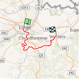
Trail Mountain bike of 57 km to be discovered at Wallonia, Liège, Liège. This trail is proposed by francois58.
Description
Itinéraire VTC de Liège à Verviers par le Ravel de l'Ourthe, la montée vers Banneux, un beau point de vue sur Theux puis retour au calme par la vallée de la Vesdre
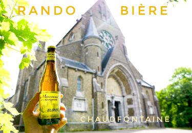
Randonnée Elèves 2014 Jour 3/3
Positioning
Country:
Belgium
Region :
Wallonia
Department/Province :
Liège
Municipality :
Liège
Location:
Angleur
Start:(Dec)
Start:(UTM)
681249 ; 5612551 (31U) N.
Comments
Trails nearby
![Trail Walking Liège - Nuit du scoutisme - Liège - Photo](https://media.geolcdn.com/t/375/260/9ee5fcc5-2ed6-4f9c-9105-1fa3b4422f73.jpg&format=jpg&maxdim=2)
![Walking Walking](https://static1.geolcdn.com/sitytour/trail-icons/101.png)
Nuit du scoutisme - Liège
Walking
Easy
(12)
Liège,
Wallonia,
Liège,
Belgium
![](/images/other/stat-length.png)
4.2 km | 6 km-effort
1h 19min
![](https://static1.geolcdn.com/siteimages/upload/files/16400158638029165_repeat_loop_refresh_sync_direction_icon.png)
Yes
![Trail Walking Liège - coteaux de la citadelle liège - Photo](https://media.geolcdn.com/t/375/260/ext.jpg?maxdim=2&url=https%3A%2F%2Fservices.sitytrail.com%2FGeolivesWS%2FDownloadMedia.ashx%3FTrailID%3D114030%26Media%3D89e4d7f6-fadf-43e4-96ab-3cccd7baadb9.jpg)
![Walking Walking](https://static1.geolcdn.com/sitytour/trail-icons/101.png)
coteaux de la citadelle liège
Walking
Medium
(6)
Liège,
Wallonia,
Liège,
Belgium
![](/images/other/stat-length.png)
14.3 km | 19.8 km-effort
7h 4min
![](https://static1.geolcdn.com/siteimages/upload/files/16400158638029165_repeat_loop_refresh_sync_direction_icon.png)
Yes
![Trail Walking Liège - GG-Lg-10_Angleur - Nessonvaux - Photo](https://media.geolcdn.com/t/375/260/04d5e1fb-7fbe-4c80-8636-73a8d0ed7b0e.jpg&format=jpg&maxdim=2)
![Walking Walking](https://static1.geolcdn.com/sitytour/trail-icons/101.png)
GG-Lg-10_Angleur - Nessonvaux
Walking
Very difficult
(2)
Liège,
Wallonia,
Liège,
Belgium
![](/images/other/stat-length.png)
22 km | 32 km-effort
6h 27min
![](https://static1.geolcdn.com/siteimages/upload/files/16400158638029165_repeat_loop_refresh_sync_direction_icon.png)
No
![Trail Walking Liège - liege st lambert versant gauche entre ville et nature - Photo](https://media.geolcdn.com/t/375/260/88c52680-ebe2-4244-8d59-4bcee560958c.jpg&format=jpg&maxdim=2)
![Walking Walking](https://static1.geolcdn.com/sitytour/trail-icons/101.png)
liege st lambert versant gauche entre ville et nature
Walking
Medium
(1)
Liège,
Wallonia,
Liège,
Belgium
![](/images/other/stat-length.png)
10.5 km | 14 km-effort
2h 31min
![](https://static1.geolcdn.com/siteimages/upload/files/16400158638029165_repeat_loop_refresh_sync_direction_icon.png)
Yes
![Trail Walking Chaudfontaine - La découverte de Sauheid et rocher du bout du monde - Photo](https://media.geolcdn.com/t/375/260/13dd1432-7408-4af2-9183-0d845172c158.jpg&format=jpg&maxdim=2)
![Walking Walking](https://static1.geolcdn.com/sitytour/trail-icons/101.png)
La découverte de Sauheid et rocher du bout du monde
Walking
Medium
(1)
Chaudfontaine,
Wallonia,
Liège,
Belgium
![](/images/other/stat-length.png)
7.8 km | 10.2 km-effort
2h 18min
![](https://static1.geolcdn.com/siteimages/upload/files/16400158638029165_repeat_loop_refresh_sync_direction_icon.png)
Yes
![Trail Walking Liège - 2021-03-07_15h45m11_1615128300605_UnnMrtGYyrs - Photo](https://media.geolcdn.com/t/375/260/1db82134-c6f1-4cf9-9ec5-4781d8a78844.jpg&format=jpg&maxdim=2)
![Walking Walking](https://static1.geolcdn.com/sitytour/trail-icons/101.png)
2021-03-07_15h45m11_1615128300605_UnnMrtGYyrs
Walking
Easy
(1)
Liège,
Wallonia,
Liège,
Belgium
![](/images/other/stat-length.png)
3 km | 3.9 km-effort
53min
![](https://static1.geolcdn.com/siteimages/upload/files/16400158638029165_repeat_loop_refresh_sync_direction_icon.png)
Yes
![Trail Walking Liège - angleur . bois st Jacques . sart tilman . bois st laurent . angleur - Photo](https://media.geolcdn.com/t/375/260/5602ae0a-194b-47b6-a04f-43cf9258bbf9.jpg&format=jpg&maxdim=2)
![Walking Walking](https://static1.geolcdn.com/sitytour/trail-icons/101.png)
angleur . bois st Jacques . sart tilman . bois st laurent . angleur
Walking
Very easy
(4)
Liège,
Wallonia,
Liège,
Belgium
![](/images/other/stat-length.png)
10.9 km | 14.1 km-effort
2h 40min
![](https://static1.geolcdn.com/siteimages/upload/files/16400158638029165_repeat_loop_refresh_sync_direction_icon.png)
Yes
![Trail Walking Chaudfontaine - A la découverte des Thermes et Coteaux: La Chapelle St Anne - Photo](https://media.geolcdn.com/t/375/260/6a396cf7-4042-42d2-b979-a2139ec4e634.jpg&format=jpg&maxdim=2)
![Walking Walking](https://static1.geolcdn.com/sitytour/trail-icons/101.png)
A la découverte des Thermes et Coteaux: La Chapelle St Anne
Walking
Medium
(1)
Chaudfontaine,
Wallonia,
Liège,
Belgium
![](/images/other/stat-length.png)
7.2 km | 10.4 km-effort
2h 12min
![](https://static1.geolcdn.com/siteimages/upload/files/16400158638029165_repeat_loop_refresh_sync_direction_icon.png)
Yes
![Trail Walking Liège - Angleur au fil de l'eau - Photo](https://media.geolcdn.com/t/375/260/ext.jpg?maxdim=2&url=https%3A%2F%2Fservices.sitytrail.com%2FGeolivesWS%2FDownloadMedia.ashx%3FTrailID%3D163767%26Media%3D20121122171817.jpeg)
![Walking Walking](https://static1.geolcdn.com/sitytour/trail-icons/101.png)
Angleur au fil de l'eau
Walking
Very easy
(1)
Liège,
Wallonia,
Liège,
Belgium
![](/images/other/stat-length.png)
5.9 km | 6.5 km-effort
1h 29min
![](https://static1.geolcdn.com/siteimages/upload/files/16400158638029165_repeat_loop_refresh_sync_direction_icon.png)
Yes