Trail Walking Manacor - estany porto cristo majorque - Photo

estany porto cristo majorque

© OpenStreetMap contributors
Length
Length
13 km
Max alt
Max alt
49 m
Uphill gradient
Uphill gradient
215 m
Km-Effort
Km-Effort  
15.8 km
Min alt
Min alt
1 m
Downhill gradient
Downhill gradient
192 m
Boucle
Boucle
No
Creation date :
2022-10-10 07:33:44.367
Updated on :
2022-10-10 12:26:29.809

(0 Reviews)

Walking
Walking
3h29
Difficulty : Easy

Scan this QR Code to open this trail in the SityTrail application

FREE GPS app for hiking

Logo SityTrail SityTrail

IGN / Geographical institutes

Download SityTrail from the App Store Download SityTrail from Google Play

Logo SityTrail SityTrail World

The world is yours!

Download SityTrail from the App Store Download SityTrail from Google Play Download SityTrail on Huawei AppGallery

About

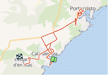
Trail Walking of 13 km to be discovered at Balearic Islands, Unknown, Manacor. This trail is proposed by GRISON-Alain.

Description

aller par la côte - cuervas del drach

Elevation profile

Positioning

Country:
Spain
Region :
Balearic Islands
Department/Province :
Unknown
Municipality :
Manacor
Location:
Unknown
Start:(UTM)
527118 ; 4374171 (31S) N.

Trails nearby

Trail Walking Manacor - Majorque marnamara les plage - Photo
Walking
yves62410

Walking

Easy
Manacor, Balearic Islands, Unknown, Spain
8 km | 10.1 km-effort
2h 58min
Yes
Trail Mountain bike Manacor - Majorque-jour 3-portocristo-canyamel-arta-portocristo - Photo
Mountain bike
jeanphi.hennebert

Mountain bike

Very difficult
Manacor, Balearic Islands, Unknown, Spain
61 km | 69 km-effort
4h 46min
No
Trail Walking Manacor - Mallorca Calo blanco - Photo
Walking
Joludov

Walking

Medium
Manacor, Balearic Islands, Unknown, Spain
5.4 km | 6.3 km-effort
1h 19min
No


Close
My subscriptions