Trail Walking Chamarande - Forêt Départementale du Belvédère à Chamarande - Photo

Forêt Départementale du Belvédère à Chamarande

 guydu41
guydu41

User

© OpenStreetMap contributors
Length
Length
5.9 km
Max alt
Max alt
156 m
Uphill gradient
Uphill gradient
113 m
Km-Effort
Km-Effort  
7.4 km
Min alt
Min alt
84 m
Downhill gradient
Downhill gradient
113 m
Boucle
Boucle
Yes
Creation date :
2022-10-07 11:51:34.526
Updated on :
2022-10-08 02:51:20.471

(0 Reviews)

Walking
Walking
2h26
Difficulty : Difficult

Scan this QR Code to open this trail in the SityTrail application

FREE GPS app for hiking

Logo SityTrail SityTrail

IGN / Geographical institutes

Download SityTrail from the App Store Download SityTrail from Google Play

Logo SityTrail SityTrail World

The world is yours!

Download SityTrail from the App Store Download SityTrail from Google Play Download SityTrail on Huawei AppGallery

About

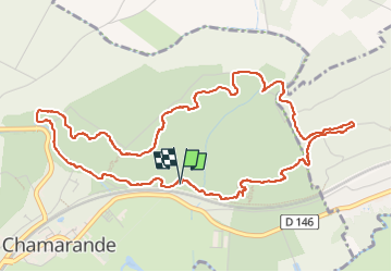
Trail Walking of 5.9 km to be discovered at Ile-de-France, Essonne, Chamarande. This trail is proposed by guydu41.

Description

Ce circuit de 6 km au départ du parking  de l'Allée Royale à Chamarande 91730 permet de découvrir les innombrables chaos rocheux, les points de vue, les nombreux sentiers et chemins tortueux dont certains escarpés de la Forêt Départementale du Belvédère. Il passe à proximité de deux abris sous roche.

Elevation profile

Photos

82 photos in total. Please click on a photo to see them all in the gallery.

Positioning

Country:
France
Region :
Ile-de-France
Department/Province :
Essonne
Municipality :
Chamarande
Location:
Unknown
Start:(UTM)
442917 ; 5374033 (31U) N.

Trails nearby

Trail Walking Lardy - Lardy - Chamarande -F - Photo
Walking
nicolas93

Walking

Medium
(2)
Lardy, Ile-de-France, Essonne, France
18.3 km | 22 km-effort
4h 44min
Yes
Trail Walking Saint-Sulpice-de-Favières - Les Pétales de Souzy - Photo
Walking
tracegps

Walking

Difficult
(1)
Saint-Sulpice-de-Favières, Ile-de-France, Essonne, France
23 km | 29 km-effort
4h 49min
Yes
Trail Walking Lardy - Autour de Lardy par la Pierre levée de Janville sur Juine - Photo
Walking
tracegps

Walking

Difficult
(1)
Lardy, Ile-de-France, Essonne, France
24 km | 29 km-effort
4h 49min
Yes
Trail Mountain bike Lardy - Autour de Lardy en VTT - Photo
Mountain bike
tracegps

Mountain bike

Medium
(1)
Lardy, Ile-de-France, Essonne, France
31 km | 38 km-effort
2h 4min
Yes
Trail On foot Auvers-Saint-Georges - Au grès de la Juine - Photo
On foot
PRO

On foot

Medium
Auvers-Saint-Georges, Ile-de-France, Essonne, France
22 km | 27 km-effort
6h 10min
No
Trail Walking Étréchy - Boucle de 2 jours au départ d'Etréchy via Etampes Chalo St Mars - Photo
Walking
philippebenne

Walking

Very difficult
(1)
Étréchy, Ile-de-France, Essonne, France
42 km | 51 km-effort
11h 28min
Yes
Trail Walking Saint-Sulpice-de-Favières - St Sulpice - Photo
Walking
Auger91

Walking

Medium
(1)
Saint-Sulpice-de-Favières, Ile-de-France, Essonne, France
8 km | 10.1 km-effort
2h 18min
Yes
Trail Walking Boissy-sous-Saint-Yon - Carrière de Madagascar  - Photo
Walking
danbott

Walking

Very easy
(1)
Boissy-sous-Saint-Yon, Ile-de-France, Essonne, France
13.2 km | 16.5 km-effort
2h 59min
Yes
Trail On foot Lardy - Boucle Lardy par Pascale - Photo
On foot
chessyca

On foot

Easy
Lardy, Ile-de-France, Essonne, France
20 km | 25 km-effort
5h 36min
Yes


Close
My subscriptions