![](/images/other/stat-length.png)
![Trail Walking Saint-Maur-des-Fossés - Des Marronniers à Nation - Photo](https://media.geolcdn.com/t/1900/400/ext.pjpeg?maxdim=2&url=https%3A%2F%2Fstatic1.geolcdn.com%2Fsiteimages%2Fupload%2Ffiles%2F1553511878bg_sport_marche.png)
Des Marronniers à Nation
Randos du mercredi
Le mercredi c'est rando
![Length](/images/other/stat-length.png)
Length
10.9 km
![Max alt](https://static1.geolcdn.com/siteimages/upload/files/1508320355ic_sort_altitude_max_24dp.png)
Max alt
73 m
![Uphill gradient](https://static1.geolcdn.com/siteimages/upload/files/1508320355ic_sort_den_pos_24dp.png)
Uphill gradient
104 m
![Km-Effort](/images/other/stat-length.png)
Km-Effort
12.3 km
![Min alt](https://static1.geolcdn.com/siteimages/upload/files/1508320355ic_sort_altitude_min_24dp.png)
Min alt
34 m
![Downhill gradient](https://static1.geolcdn.com/siteimages/upload/files/1508320355ic_sort_den_neg_24dp.png)
Downhill gradient
101 m
![Boucle](https://static1.geolcdn.com/siteimages/upload/files/16400158638029165_repeat_loop_refresh_sync_direction_icon.png)
Boucle
No
Creation date :
2022-10-02 13:44:06.9
Updated on :
2022-10-02 14:28:22.326
![Walking](https://static1.geolcdn.com/sitytour/trail-icons/101.png)
2h50
Difficulty : Difficult
![Scan this QR Code to open this trail in the SityTrail application](https://capi.geolives.com/qq0zvz2zws4bq2lad0pu/sitytour/trails/3410469/qr.png?size=200)
FREE GPS app for hiking
About
Trail Walking of 10.9 km to be discovered at Ile-de-France, Val-de-Marne, Saint-Maur-des-Fossés. This trail is proposed by Randos du mercredi.
Description
Rando d'AM
Première rando de la saison 2022-2023
Positioning
Country:
France
Region :
Ile-de-France
Department/Province :
Val-de-Marne
Municipality :
Saint-Maur-des-Fossés
Location:
Unknown
Start:(Dec)
Start:(UTM)
463006 ; 5405876 (31U) N.
Comments
Trails nearby
![Trail Walking Chennevières-sur-Marne - J 18 12 km Pont de Chennevières - Photo](https://media.geolcdn.com/t/375/260/6347577b-7c01-4d78-a0ab-c4e201132c35.jpg&format=jpg&maxdim=2)
![Walking Walking](https://static1.geolcdn.com/sitytour/trail-icons/101.png)
J 18 12 km Pont de Chennevières
Walking
Medium
(5)
Chennevières-sur-Marne,
Ile-de-France,
Val-de-Marne,
France
![](/images/other/stat-length.png)
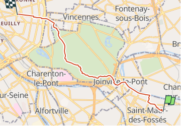
11 km | 12 km-effort
2h 42min
![](https://static1.geolcdn.com/siteimages/upload/files/16400158638029165_repeat_loop_refresh_sync_direction_icon.png)
Yes
![Trail Walking Noiseau - depuis Noiseau - Photo](https://media.geolcdn.com/t/375/260/ext.jpg?maxdim=2&url=https%3A%2F%2Fservices.sitytrail.com%2FGeolivesWS%2FDownloadMedia.ashx%3FTrailID%3D169363%26Media%3D20130109131150.jpeg)
![Walking Walking](https://static1.geolcdn.com/sitytour/trail-icons/101.png)
depuis Noiseau
Walking
Easy
(2)
Noiseau,
Ile-de-France,
Val-de-Marne,
France
![](/images/other/stat-length.png)
17 km | 19.1 km-effort
4h 35min
![](https://static1.geolcdn.com/siteimages/upload/files/16400158638029165_repeat_loop_refresh_sync_direction_icon.png)
Yes
![Trail Walking Saint-Maur-des-Fossés - 2025-01-08_16h55m46_de saint maur des fossés à école véterinaire au bord de la marne - Photo](https://media.geolcdn.com/t/375/260/ext.jpg?maxdim=2&url=https%3A%2F%2Fstatic1.geolcdn.com%2Fsiteimages%2Fupload%2Ffiles%2F1553511878bg_sport_marche.png)
![Walking Walking](https://static1.geolcdn.com/sitytour/trail-icons/101.png)
2025-01-08_16h55m46_de saint maur des fossés à école véterinaire au bord de l...
Walking
Difficult
(1)
Saint-Maur-des-Fossés,
Ile-de-France,
Val-de-Marne,
France
![](/images/other/stat-length.png)
17.4 km | 18.9 km-effort
4h 17min
![](https://static1.geolcdn.com/siteimages/upload/files/16400158638029165_repeat_loop_refresh_sync_direction_icon.png)
No
![Trail Walking Vincennes - Vincennes parcours architectural - Photo](https://media.geolcdn.com/t/375/260/5abdfb6b-f8e3-406a-a199-f0f63635a14c.jpg&format=jpg&maxdim=2)
![Walking Walking](https://static1.geolcdn.com/sitytour/trail-icons/101.png)
Vincennes parcours architectural
Walking
Very easy
Vincennes,
Ile-de-France,
Val-de-Marne,
France
![](/images/other/stat-length.png)
6 km | 6.6 km-effort
1h 22min
![](https://static1.geolcdn.com/siteimages/upload/files/16400158638029165_repeat_loop_refresh_sync_direction_icon.png)
No
![Trail Walking Vincennes - Parcours street art Vincennes au 18/10/2024 - Photo](https://media.geolcdn.com/t/375/260/417378cf-603b-415f-a769-d28d8227e90e.jpg&format=jpg&maxdim=2)
![Walking Walking](https://static1.geolcdn.com/sitytour/trail-icons/101.png)
Parcours street art Vincennes au 18/10/2024
Walking
Very easy
Vincennes,
Ile-de-France,
Val-de-Marne,
France
![](/images/other/stat-length.png)
4.1 km | 4.3 km-effort
58min
![](https://static1.geolcdn.com/siteimages/upload/files/16400158638029165_repeat_loop_refresh_sync_direction_icon.png)
No
![Trail Walking Saint-Maur-des-Fossés - Randopolitain les bords de Marne 18 km - Photo](https://media.geolcdn.com/t/375/260/1f0cf9d1-3287-43b2-b3a1-db1ac230c6c3.jpg&format=jpg&maxdim=2)
![Walking Walking](https://static1.geolcdn.com/sitytour/trail-icons/101.png)
Randopolitain les bords de Marne 18 km
Walking
Easy
Saint-Maur-des-Fossés,
Ile-de-France,
Val-de-Marne,
France
![](/images/other/stat-length.png)
17.2 km | 18.8 km-effort
4h 2min
![](https://static1.geolcdn.com/siteimages/upload/files/16400158638029165_repeat_loop_refresh_sync_direction_icon.png)
No
![Trail On foot Créteil - JC 84 - La Végétale - 18,2 km - Photo](https://media.geolcdn.com/t/375/260/ext.jpg?maxdim=2&url=https%3A%2F%2Fstatic1.geolcdn.com%2Fsiteimages%2Fupload%2Ffiles%2F1545311037marcheuse_200dpi.jpg)
![On foot On foot](https://static1.geolcdn.com/sitytour/trail-icons/100.png)
JC 84 - La Végétale - 18,2 km
On foot
Difficult
(1)
Créteil,
Ile-de-France,
Val-de-Marne,
France
![](/images/other/stat-length.png)
18.3 km | 21 km-effort
4h 40min
![](https://static1.geolcdn.com/siteimages/upload/files/16400158638029165_repeat_loop_refresh_sync_direction_icon.png)
No
![Trail Walking Sucy-en-Brie - Boucle Sucy en Brie sans difficultés - Photo](https://media.geolcdn.com/t/375/260/65383356-6c0f-415e-ae66-98274ac67ff0.jpg&format=jpg&maxdim=2)
![Walking Walking](https://static1.geolcdn.com/sitytour/trail-icons/101.png)
Boucle Sucy en Brie sans difficultés
Walking
Very easy
Sucy-en-Brie,
Ile-de-France,
Val-de-Marne,
France
![](/images/other/stat-length.png)
19.8 km | 23 km-effort
4h 26min
![](https://static1.geolcdn.com/siteimages/upload/files/16400158638029165_repeat_loop_refresh_sync_direction_icon.png)
Yes
![Trail Walking Créteil - Parc départemental et tour lac Créteil 15 km - Photo](https://media.geolcdn.com/t/375/260/ext.jpg?maxdim=2&url=https%3A%2F%2Fstatic1.geolcdn.com%2Fsiteimages%2Fupload%2Ffiles%2F1553511878bg_sport_marche.png)
![Walking Walking](https://static1.geolcdn.com/sitytour/trail-icons/101.png)
Parc départemental et tour lac Créteil 15 km
Walking
Difficult
(1)
Créteil,
Ile-de-France,
Val-de-Marne,
France
![](/images/other/stat-length.png)
14.4 km | 16.2 km-effort
3h 41min
![](https://static1.geolcdn.com/siteimages/upload/files/16400158638029165_repeat_loop_refresh_sync_direction_icon.png)
Yes