![](/images/other/stat-length.png)
![Trail Walking Arboras - Arboras - Photo](https://media.geolcdn.com/t/1900/400/ext.pjpeg?maxdim=2&url=https%3A%2F%2Fstatic1.geolcdn.com%2Fsiteimages%2Fupload%2Ffiles%2F1553511878bg_sport_marche.png)
Arboras
Levant
User
![Length](/images/other/stat-length.png)
Length
13.9 km
![Max alt](https://static1.geolcdn.com/siteimages/upload/files/1508320355ic_sort_altitude_max_24dp.png)
Max alt
521 m
![Uphill gradient](https://static1.geolcdn.com/siteimages/upload/files/1508320355ic_sort_den_pos_24dp.png)
Uphill gradient
462 m
![Km-Effort](/images/other/stat-length.png)
Km-Effort
20 km
![Min alt](https://static1.geolcdn.com/siteimages/upload/files/1508320355ic_sort_altitude_min_24dp.png)
Min alt
160 m
![Downhill gradient](https://static1.geolcdn.com/siteimages/upload/files/1508320355ic_sort_den_neg_24dp.png)
Downhill gradient
447 m
![Boucle](https://static1.geolcdn.com/siteimages/upload/files/16400158638029165_repeat_loop_refresh_sync_direction_icon.png)
Boucle
Yes
Creation date :
2022-10-02 13:29:23.027
Updated on :
2022-10-09 14:59:29.367
![Walking](https://static1.geolcdn.com/sitytour/trail-icons/101.png)
4h32
Difficulty : Very difficult
![Scan this QR Code to open this trail in the SityTrail application](https://capi.geolives.com/qq0zvz2zws4bq2lad0pu/sitytour/trails/3410452/qr.png?size=200)
FREE GPS app for hiking
About
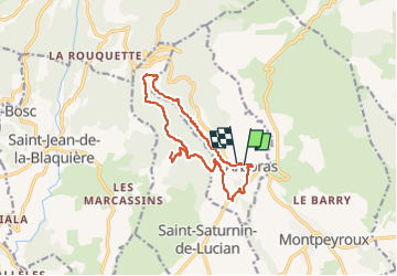
Trail Walking of 13.9 km to be discovered at Occitania, Hérault, Arboras. This trail is proposed by Levant .
Description
Départ du village d'Arboras.
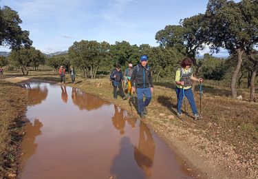
Suivre la piste longeant le ruisseau de Lagamas.
Au lieu dit Métairies de vergnes passer sur l'autre versant en direction du rocher des vierges
Aller-retour jusqu'au belvédère
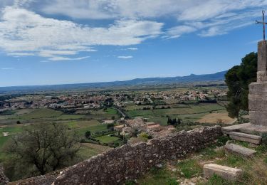
Retour sur Arboras par le GR
Positioning
Country:
France
Region :
Occitania
Department/Province :
Hérault
Municipality :
Arboras
Location:
Unknown
Start:(Dec)
Start:(UTM)
538928 ; 4839887 (31T) N.
Comments
Trails nearby
![Trail Walking Saint-Saturnin-de-Lucian - Le Rocher des vierges - Photo](https://media.geolcdn.com/t/375/260/ext.jpg?maxdim=2&url=https%3A%2F%2Fservices.sitytrail.com%2FGeolivesWS%2FDownloadMedia.ashx%3FTrailID%3D874639%26Media%3D20171212140026.jpg)
![Walking Walking](https://static1.geolcdn.com/sitytour/trail-icons/101.png)
Le Rocher des vierges
Walking
Medium
(2)
Saint-Saturnin-de-Lucian,
Occitania,
Hérault,
France
![](/images/other/stat-length.png)
12.1 km | 17.4 km-effort
5h 1min
![](https://static1.geolcdn.com/siteimages/upload/files/16400158638029165_repeat_loop_refresh_sync_direction_icon.png)
Yes
![Trail Walking Montpeyroux - château de castelas - Photo](https://media.geolcdn.com/t/375/260/ext.jpg?maxdim=2&url=https%3A%2F%2Fservices.sitytrail.com%2FGeolivesWS%2FDownloadMedia.ashx%3FTrailID%3D221327%26Media%3D20130914120534.jpg)
![Walking Walking](https://static1.geolcdn.com/sitytour/trail-icons/101.png)
château de castelas
Walking
Easy
(3)
Montpeyroux,
Occitania,
Hérault,
France
![](/images/other/stat-length.png)
10.3 km | 15.1 km-effort
3h 12min
![](https://static1.geolcdn.com/siteimages/upload/files/16400158638029165_repeat_loop_refresh_sync_direction_icon.png)
Yes
![Trail Walking Montpeyroux - Saint baudille - Photo](https://media.geolcdn.com/t/375/260/ext.jpg?maxdim=2&url=https%3A%2F%2Fservices.sitytrail.com%2FGeolivesWS%2FDownloadMedia.ashx%3FTrailID%3D246463%26Media%3Dfix__20140202141416.jpg)
![Walking Walking](https://static1.geolcdn.com/sitytour/trail-icons/101.png)
Saint baudille
Walking
Easy
(3)
Montpeyroux,
Occitania,
Hérault,
France
![](/images/other/stat-length.png)
10.2 km | 16.2 km-effort
3h 22min
![](https://static1.geolcdn.com/siteimages/upload/files/16400158638029165_repeat_loop_refresh_sync_direction_icon.png)
Yes
![Trail Walking Saint-Jean-de-la-Blaquière - Les Bois de Homs et de Latude - Photo](https://media.geolcdn.com/t/375/260/ext.jpg?maxdim=2&url=https%3A%2F%2Fstatic1.geolcdn.com%2Fsiteimages%2Fupload%2Ffiles%2F1553511878bg_sport_marche.png)
![Walking Walking](https://static1.geolcdn.com/sitytour/trail-icons/101.png)
Les Bois de Homs et de Latude
Walking
Easy
(1)
Saint-Jean-de-la-Blaquière,
Occitania,
Hérault,
France
![](/images/other/stat-length.png)
9.3 km | 13.1 km-effort
2h 27min
![](https://static1.geolcdn.com/siteimages/upload/files/16400158638029165_repeat_loop_refresh_sync_direction_icon.png)
Yes
![Trail Walking Ceyras - Aventure dans le canyon du diable - Photo](https://media.geolcdn.com/t/375/260/e739ef44-15d9-4278-988c-476153253e23.jpg&format=jpg&maxdim=2)
![Walking Walking](https://static1.geolcdn.com/sitytour/trail-icons/101.png)
Aventure dans le canyon du diable
Walking
Medium
Ceyras,
Occitania,
Hérault,
France
![](/images/other/stat-length.png)
13.6 km | 17.9 km-effort
5h 37min
![](https://static1.geolcdn.com/siteimages/upload/files/16400158638029165_repeat_loop_refresh_sync_direction_icon.png)
Yes
![Trail Walking Montpeyroux - Saint-Baudille - Photo](https://media.geolcdn.com/t/375/260/58bec8c6-cffd-4c3b-ad5e-045ac6c12b87.jpg&format=jpg&maxdim=2)
![Walking Walking](https://static1.geolcdn.com/sitytour/trail-icons/101.png)
Saint-Baudille
Walking
Medium
Montpeyroux,
Occitania,
Hérault,
France
![](/images/other/stat-length.png)
13.8 km | 21 km-effort
4h 30min
![](https://static1.geolcdn.com/siteimages/upload/files/16400158638029165_repeat_loop_refresh_sync_direction_icon.png)
Yes
![Trail Walking Montpeyroux - Font du Griffe le Baudille - Photo](https://media.geolcdn.com/t/375/260/443db8a3-4e7a-451b-87ed-5204bd667dbf.jpg&format=jpg&maxdim=2)
![Walking Walking](https://static1.geolcdn.com/sitytour/trail-icons/101.png)
Font du Griffe le Baudille
Walking
Difficult
Montpeyroux,
Occitania,
Hérault,
France
![](/images/other/stat-length.png)
10.8 km | 16.8 km-effort
3h 32min
![](https://static1.geolcdn.com/siteimages/upload/files/16400158638029165_repeat_loop_refresh_sync_direction_icon.png)
Yes
![Trail Walking Montpeyroux - Le bary Arboras le Castelas - Photo](https://media.geolcdn.com/t/375/260/be1b8dbb-902e-4f34-ac2c-776d8a42a8d8.jpg&format=jpg&maxdim=2)
![Walking Walking](https://static1.geolcdn.com/sitytour/trail-icons/101.png)
Le bary Arboras le Castelas
Walking
Easy
Montpeyroux,
Occitania,
Hérault,
France
![](/images/other/stat-length.png)
11.8 km | 17.1 km-effort
5h 7min
![](https://static1.geolcdn.com/siteimages/upload/files/16400158638029165_repeat_loop_refresh_sync_direction_icon.png)
Yes
![Walking Walking](https://static1.geolcdn.com/sitytour/trail-icons/101.png)
2024-02-18_02h39m01_suuntoapp-Walking-2024-02-17T10-19-40Z-route
Walking
Difficult
Montpeyroux,
Occitania,
Hérault,
France
![](/images/other/stat-length.png)
11.5 km | 17.5 km-effort
3h 58min
![](https://static1.geolcdn.com/siteimages/upload/files/16400158638029165_repeat_loop_refresh_sync_direction_icon.png)
Yes