![](/images/other/stat-length.png)
![Trail Walking Seraing - Bois de la Vecquee - Seraing - Photo](https://media.geolcdn.com/t/1900/400/ext.pjpeg?maxdim=2&url=https%3A%2F%2Fstatic1.geolcdn.com%2Fsiteimages%2Fupload%2Ffiles%2F1553511878bg_sport_marche.png)
Bois de la Vecquee - Seraing
estellecharlier
User
![Length](/images/other/stat-length.png)
Length
5.1 km
![Max alt](https://static1.geolcdn.com/siteimages/upload/files/1508320355ic_sort_altitude_max_24dp.png)
Max alt
275 m
![Uphill gradient](https://static1.geolcdn.com/siteimages/upload/files/1508320355ic_sort_den_pos_24dp.png)
Uphill gradient
55 m
![Km-Effort](/images/other/stat-length.png)
Km-Effort
5.8 km
![Min alt](https://static1.geolcdn.com/siteimages/upload/files/1508320355ic_sort_altitude_min_24dp.png)
Min alt
249 m
![Downhill gradient](https://static1.geolcdn.com/siteimages/upload/files/1508320355ic_sort_den_neg_24dp.png)
Downhill gradient
54 m
![Boucle](https://static1.geolcdn.com/siteimages/upload/files/16400158638029165_repeat_loop_refresh_sync_direction_icon.png)
Boucle
Yes
Creation date :
2022-10-01 07:56:48.163
Updated on :
2022-10-01 09:30:33.662
![Walking](https://static1.geolcdn.com/sitytour/trail-icons/101.png)
1h13
Difficulty : Easy
![Scan this QR Code to open this trail in the SityTrail application](https://capi.geolives.com/qq0zvz2zws4bq2lad0pu/sitytour/trails/3409136/qr.png?size=200)
FREE GPS app for hiking
About
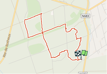
Trail Walking of 5.1 km to be discovered at Wallonia, Liège, Seraing. This trail is proposed by estellecharlier.
Description
Attention au début un passage hors sentier dans les bois. Il y avait l'air d'avoir un chemin mais celui-ci s'arrête au milieu du bois. Pour éviter ça, vous pouvez prendre le chemin plus loin à gauche.
Positioning
Country:
Belgium
Region :
Wallonia
Department/Province :
Liège
Municipality :
Seraing
Location:
Unknown
Start:(Dec)
Start:(UTM)
678671 ; 5603944 (31U) N.
Comments
Trails nearby
![Trail Walking Esneux - Esneux bois du mary - Photo](https://media.geolcdn.com/t/375/260/71c77441-f9b7-4220-bb0a-fbf9c3317653.jpg&format=jpg&maxdim=2)
![Walking Walking](https://static1.geolcdn.com/sitytour/trail-icons/101.png)
Esneux bois du mary
Walking
Easy
(5)
Esneux,
Wallonia,
Liège,
Belgium
![](/images/other/stat-length.png)
4.4 km | 5.9 km-effort
1h 11min
![](https://static1.geolcdn.com/siteimages/upload/files/16400158638029165_repeat_loop_refresh_sync_direction_icon.png)
Yes
![Trail Walking Esneux - RB-Lg-20_Tilff - Photo](https://media.geolcdn.com/t/375/260/ext.jpg?maxdim=2&url=https%3A%2F%2Fservices.sitytrail.com%2FGeolivesWS%2FDownloadMedia.ashx%3FTrailID%3D400739%26Media%3D2cb4df8e-af53-4650-9797-54389fe3086f.jpg)
![Walking Walking](https://static1.geolcdn.com/sitytour/trail-icons/101.png)
RB-Lg-20_Tilff
Walking
Very difficult
(7)
Esneux,
Wallonia,
Liège,
Belgium
![](/images/other/stat-length.png)
20 km | 28 km-effort
6h 21min
![](https://static1.geolcdn.com/siteimages/upload/files/16400158638029165_repeat_loop_refresh_sync_direction_icon.png)
Yes
![Trail Walking Neupré - Neupré - liaisons inter-hameaux et -villages - Photo](https://media.geolcdn.com/t/375/260/ext.jpg?maxdim=2&url=https%3A%2F%2Fservices.sitytrail.com%2FGeolivesWS%2FDownloadMedia.ashx%3FTrailID%3D347446%26Media%3Dfix__20140903123425.jpg)
![Walking Walking](https://static1.geolcdn.com/sitytour/trail-icons/101.png)
Neupré - liaisons inter-hameaux et -villages
Walking
Medium
(13)
Neupré,
Wallonia,
Liège,
Belgium
![](/images/other/stat-length.png)
10.8 km | 14.1 km-effort
2h 59min
![](https://static1.geolcdn.com/siteimages/upload/files/16400158638029165_repeat_loop_refresh_sync_direction_icon.png)
Yes
![Trail Walking Neupré - Neupré - les contreforts de la Boucle de l'Ourthe - Photo](https://media.geolcdn.com/t/375/260/ext.jpg?maxdim=2&url=https%3A%2F%2Fservices.sitytrail.com%2FGeolivesWS%2FDownloadMedia.ashx%3FTrailID%3D347434%26Media%3Dfix__20140909180027.jpg)
![Walking Walking](https://static1.geolcdn.com/sitytour/trail-icons/101.png)
Neupré - les contreforts de la Boucle de l'Ourthe
Walking
Medium
(18)
Neupré,
Wallonia,
Liège,
Belgium
![](/images/other/stat-length.png)
7.9 km | 10.9 km-effort
2h 21min
![](https://static1.geolcdn.com/siteimages/upload/files/16400158638029165_repeat_loop_refresh_sync_direction_icon.png)
Yes
![Trail Walking Esneux - RB-LG-10 - Raccourci - Photo](https://media.geolcdn.com/t/375/260/ext.jpg?maxdim=2&url=https%3A%2F%2Fservices.sitytrail.com%2FGeolivesWS%2FDownloadMedia.ashx%3FTrailID%3D209422%26Media%3D464c3dd7-df43-4893-8019-c771f2bd17f1.jpg)
![Walking Walking](https://static1.geolcdn.com/sitytour/trail-icons/101.png)
RB-LG-10 - Raccourci
Walking
Difficult
(7)
Esneux,
Wallonia,
Liège,
Belgium
![](/images/other/stat-length.png)
11 km | 15.1 km-effort
3h 26min
![](https://static1.geolcdn.com/siteimages/upload/files/16400158638029165_repeat_loop_refresh_sync_direction_icon.png)
Yes
![Trail Walking Esneux - RB-LG-10 - Au fil de l’Ourthe : la boucle de Fêchereux et au-delà - Photo](https://media.geolcdn.com/t/375/260/ext.jpg?maxdim=2&url=https%3A%2F%2Fservices.sitytrail.com%2FGeolivesWS%2FDownloadMedia.ashx%3FTrailID%3D179568%26Media%3D18c2b0fe-ccb1-462d-9e89-f89259226c52.jpg)
![Walking Walking](https://static1.geolcdn.com/sitytour/trail-icons/101.png)
RB-LG-10 - Au fil de l’Ourthe : la boucle de Fêchereux et au-delà
Walking
Very difficult
(21)
Esneux,
Wallonia,
Liège,
Belgium
![](/images/other/stat-length.png)
21 km | 29 km-effort
6h 32min
![](https://static1.geolcdn.com/siteimages/upload/files/16400158638029165_repeat_loop_refresh_sync_direction_icon.png)
Yes
![Trail Walking Neupré - Neupré - balade de Rotheux - Photo](https://media.geolcdn.com/t/375/260/ext.jpg?maxdim=2&url=https%3A%2F%2Fservices.sitytrail.com%2FGeolivesWS%2FDownloadMedia.ashx%3FTrailID%3D347399%26Media%3D32c01f91-c180-4d53-8d7d-a74522876cd8.JPG)
![Walking Walking](https://static1.geolcdn.com/sitytour/trail-icons/101.png)
Neupré - balade de Rotheux
Walking
Medium
(11)
Neupré,
Wallonia,
Liège,
Belgium
![](/images/other/stat-length.png)
8.7 km | 11.1 km-effort
2h 21min
![](https://static1.geolcdn.com/siteimages/upload/files/16400158638029165_repeat_loop_refresh_sync_direction_icon.png)
Yes
![Trail Walking Neupré - Neupré - Sentier Paysage et Géologie - Photo](https://media.geolcdn.com/t/375/260/ext.jpg?maxdim=2&url=https%3A%2F%2Fservices.sitytrail.com%2FGeolivesWS%2FDownloadMedia.ashx%3FTrailID%3D343711%26Media%3Dfix__20140909182657.jpg)
![Walking Walking](https://static1.geolcdn.com/sitytour/trail-icons/101.png)
Neupré - Sentier Paysage et Géologie
Walking
Easy
(9)
Neupré,
Wallonia,
Liège,
Belgium
![](/images/other/stat-length.png)
2.7 km | 3.6 km-effort
50min
![](https://static1.geolcdn.com/siteimages/upload/files/16400158638029165_repeat_loop_refresh_sync_direction_icon.png)
Yes
![Trail Walking Neupré - Neupré - Balade du Chemin des morts - Photo](https://media.geolcdn.com/t/375/260/ext.jpg?maxdim=2&url=https%3A%2F%2Fstatic1.geolcdn.com%2Fsiteimages%2Fupload%2Ffiles%2F1553511878bg_sport_marche.png)
![Walking Walking](https://static1.geolcdn.com/sitytour/trail-icons/101.png)
Neupré - Balade du Chemin des morts
Walking
Medium
(15)
Neupré,
Wallonia,
Liège,
Belgium
![](/images/other/stat-length.png)
5.1 km | 7.4 km-effort
1h 33min
![](https://static1.geolcdn.com/siteimages/upload/files/16400158638029165_repeat_loop_refresh_sync_direction_icon.png)
Yes