![](/images/other/stat-length.png)
activity_9552444434
pascalou73
User GUIDE
![Length](/images/other/stat-length.png)
Length
47 km
![Max alt](https://static1.geolcdn.com/siteimages/upload/files/1508320355ic_sort_altitude_max_24dp.png)
Max alt
326 m
![Uphill gradient](https://static1.geolcdn.com/siteimages/upload/files/1508320355ic_sort_den_pos_24dp.png)
Uphill gradient
894 m
![Km-Effort](/images/other/stat-length.png)
Km-Effort
59 km
![Min alt](https://static1.geolcdn.com/siteimages/upload/files/1508320355ic_sort_altitude_min_24dp.png)
Min alt
142 m
![Downhill gradient](https://static1.geolcdn.com/siteimages/upload/files/1508320355ic_sort_den_neg_24dp.png)
Downhill gradient
906 m
![Boucle](https://static1.geolcdn.com/siteimages/upload/files/16400158638029165_repeat_loop_refresh_sync_direction_icon.png)
Boucle
No
Creation date :
2022-09-27 13:25:19.739
Updated on :
2022-09-27 13:27:18.909
![Mountain bike](https://static1.geolcdn.com/sitytour/trail-icons/202.png)
4h05
Difficulty : Very difficult
![Scan this QR Code to open this trail in the SityTrail application](https://capi.geolives.com/qq0zvz2zws4bq2lad0pu/sitytour/trails/3405512/qr.png?size=200)
FREE GPS app for hiking
About
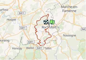
Trail Mountain bike of 47 km to be discovered at Wallonia, Namur, Rochefort. This trail is proposed by pascalou73.
Description
Voilà une belle randonnée autour du village de Rochefort un beau VTT entre les bois et campagnes et villages de la région .une randonnée de 47 km avec un beau D
Positioning
Country:
Belgium
Region :
Wallonia
Department/Province :
Namur
Municipality :
Rochefort
Location:
Unknown
Start:(Dec)
Start:(UTM)
658810 ; 5558547 (31U) N.
Comments
Trails nearby
![Trail Walking Rochefort - Havrenne & de Saint-Remy Trappist Abbey - Photo](https://media.geolcdn.com/t/375/260/ext.jpg?maxdim=2&url=https%3A%2F%2Fservices.sitytrail.com%2FGeolivesWS%2FDownloadMedia.ashx%3FTrailID%3D215623%26Media%3Db529a95c-404d-4caa-9c09-6087624067bf.tif)
![Walking Walking](https://static1.geolcdn.com/sitytour/trail-icons/101.png)
Havrenne & de Saint-Remy Trappist Abbey
Walking
Easy
(14)
Rochefort,
Wallonia,
Namur,
Belgium
![](/images/other/stat-length.png)
6 km | 7.1 km-effort
2h 0min
![](https://static1.geolcdn.com/siteimages/upload/files/16400158638029165_repeat_loop_refresh_sync_direction_icon.png)
Yes
![Trail Walking Rochefort - Nature - The view from the Belvédère in Han-sur-Lesse - Photo](https://media.geolcdn.com/t/375/260/ext.jpg?maxdim=2&url=https%3A%2F%2Fservices.sitytrail.com%2FGeolivesWS%2FDownloadMedia.ashx%3FTrailID%3D193579%26Media%3D5797bc56-5327-4c2b-b581-d88d672bf775.jpg)
![Walking Walking](https://static1.geolcdn.com/sitytour/trail-icons/101.png)
Nature - The view from the Belvédère in Han-sur-Lesse
Walking
Difficult
(16)
Rochefort,
Wallonia,
Namur,
Belgium
![](/images/other/stat-length.png)
4.8 km | 6.3 km-effort
1h 20min
![](https://static1.geolcdn.com/siteimages/upload/files/16400158638029165_repeat_loop_refresh_sync_direction_icon.png)
Yes
![Trail Motor Rochefort - Car tour - Heritage : churches, chapels and abbeys - Rochefort - Photo](https://media.geolcdn.com/t/375/260/ext.jpg?maxdim=2&url=https%3A%2F%2Fservices.sitytrail.com%2FGeolivesWS%2FDownloadMedia.ashx%3FTrailID%3D153103%26Media%3D05603f1b-9f7c-481f-bc84-6cc819555dbb.jpg)
![Motor Motor](https://static1.geolcdn.com/sitytour/trail-icons/400.png)
Car tour - Heritage : churches, chapels and abbeys - Rochefort
Motor
Easy
(5)
Rochefort,
Wallonia,
Namur,
Belgium
![](/images/other/stat-length.png)
65 km | 78 km-effort
2h 40min
![](https://static1.geolcdn.com/siteimages/upload/files/16400158638029165_repeat_loop_refresh_sync_direction_icon.png)
Yes
![Trail Walking Rochefort - RB-Na-07 Raccourci - Ronde au pays des grottes - Photo](https://media.geolcdn.com/t/375/260/ext.jpg?maxdim=2&url=https%3A%2F%2Fservices.sitytrail.com%2FGeolivesWS%2FDownloadMedia.ashx%3FTrailID%3D213757%26Media%3D27dc9085-0323-4669-9df4-56be0512bfe6.jpg)
![Walking Walking](https://static1.geolcdn.com/sitytour/trail-icons/101.png)
RB-Na-07 Raccourci - Ronde au pays des grottes
Walking
Easy
(9)
Rochefort,
Wallonia,
Namur,
Belgium
![](/images/other/stat-length.png)
18.4 km | 24 km-effort
4h 59min
![](https://static1.geolcdn.com/siteimages/upload/files/16400158638029165_repeat_loop_refresh_sync_direction_icon.png)
Yes
![Trail Walking Rochefort - Nature - A discovery trail through Han-sur-Lesse - Photo](https://media.geolcdn.com/t/375/260/ext.jpg?maxdim=2&url=https%3A%2F%2Fservices.sitytrail.com%2FGeolivesWS%2FDownloadMedia.ashx%3FTrailID%3D148989%26Media%3D3c202c2f-ee01-4903-bd25-24913ec8637b.jpg)
![Walking Walking](https://static1.geolcdn.com/sitytour/trail-icons/101.png)
Nature - A discovery trail through Han-sur-Lesse
Walking
Very easy
(15)
Rochefort,
Wallonia,
Namur,
Belgium
![](/images/other/stat-length.png)
4.8 km | 5.8 km-effort
1h 15min
![](https://static1.geolcdn.com/siteimages/upload/files/16400158638029165_repeat_loop_refresh_sync_direction_icon.png)
Yes
![Walking Walking](https://static1.geolcdn.com/sitytour/trail-icons/101.png)
GG2-Lu-34_Jemelle-Marche-en-Famenne (2021-11-04)
Walking
Medium
(1)
Rochefort,
Wallonia,
Namur,
Belgium
![](/images/other/stat-length.png)
19.2 km | 24 km-effort
5h 32min
![](https://static1.geolcdn.com/siteimages/upload/files/16400158638029165_repeat_loop_refresh_sync_direction_icon.png)
No
![Trail Motor Rochefort - Roadbook](https://media.geolcdn.com/t/375/260/ext.jpg?maxdim=2&url=https%3A%2F%2Fservices.sitytrail.com%2FGeolivesWS%2FDownloadMedia.ashx%3FTrailID%3D428715%26Media%3Dff47641a-75c9-4285-926b-b7008d6e40b8.png)
![Motor Motor](https://static1.geolcdn.com/sitytour/trail-icons/400.png)
Roadbook "On the road by car/motorbike" - "Local delicacies, crafts and tradi...
Motor
Very easy
(3)
Rochefort,
Wallonia,
Namur,
Belgium
![](/images/other/stat-length.png)
140 km | 169 km-effort
2h 0min
![](https://static1.geolcdn.com/siteimages/upload/files/16400158638029165_repeat_loop_refresh_sync_direction_icon.png)
Yes
![Trail Walking Nassogne - Forrières/Lesterny - Promenade Saint-Martin (NG 08) - Photo](https://media.geolcdn.com/t/375/260/ext.jpg?maxdim=2&url=https%3A%2F%2Fservices.sitytrail.com%2FGeolivesWS%2FDownloadMedia.ashx%3FTrailID%3D334477%26Media%3Dba77daec-7d1b-4594-8484-87260d6142b8.jpg)
![Walking Walking](https://static1.geolcdn.com/sitytour/trail-icons/101.png)
Forrières/Lesterny - Promenade Saint-Martin (NG 08)
Walking
Medium
(4)
Nassogne,
Wallonia,
Luxembourg,
Belgium
![](/images/other/stat-length.png)
7.3 km | 9 km-effort
1h 57min
![](https://static1.geolcdn.com/siteimages/upload/files/16400158638029165_repeat_loop_refresh_sync_direction_icon.png)
Yes
![Trail Walking Nassogne - Forrières - Promenade de Cocher (NG 07) - Photo](https://media.geolcdn.com/t/375/260/ext.jpg?maxdim=2&url=https%3A%2F%2Fservices.sitytrail.com%2FGeolivesWS%2FDownloadMedia.ashx%3FTrailID%3D334476%26Media%3D562f483c-8c06-4d7b-aecf-2f9a32b3894e.jpg)
![Walking Walking](https://static1.geolcdn.com/sitytour/trail-icons/101.png)
Forrières - Promenade de Cocher (NG 07)
Walking
Medium
(3)
Nassogne,
Wallonia,
Luxembourg,
Belgium
![](/images/other/stat-length.png)
5.4 km | 6.7 km-effort
1h 28min
![](https://static1.geolcdn.com/siteimages/upload/files/16400158638029165_repeat_loop_refresh_sync_direction_icon.png)
Yes