![](/images/other/stat-length.png)
![Trail Walking Villers-la-Ville - MARBAIS _ Marche Adeps _ BW _ 27/09/2022 - Photo](https://media.geolcdn.com/t/1900/400/6f80f5a3-3956-40af-a763-7bb2dec751a6.jpg&format=pjpeg&maxdim=2)
MARBAIS _ Marche Adeps _ BW _ 27/09/2022
jeangulu
User
![Length](/images/other/stat-length.png)
Length
19.2 km
![Max alt](https://static1.geolcdn.com/siteimages/upload/files/1508320355ic_sort_altitude_max_24dp.png)
Max alt
160 m
![Uphill gradient](https://static1.geolcdn.com/siteimages/upload/files/1508320355ic_sort_den_pos_24dp.png)
Uphill gradient
160 m
![Km-Effort](/images/other/stat-length.png)
Km-Effort
21 km
![Min alt](https://static1.geolcdn.com/siteimages/upload/files/1508320355ic_sort_altitude_min_24dp.png)
Min alt
126 m
![Downhill gradient](https://static1.geolcdn.com/siteimages/upload/files/1508320355ic_sort_den_neg_24dp.png)
Downhill gradient
159 m
![Boucle](https://static1.geolcdn.com/siteimages/upload/files/16400158638029165_repeat_loop_refresh_sync_direction_icon.png)
Boucle
Yes
Creation date :
2022-09-27 08:26:34.304
Updated on :
2022-09-28 08:44:07.369
![Walking](https://static1.geolcdn.com/sitytour/trail-icons/101.png)
4h28
Difficulty : Medium
![Scan this QR Code to open this trail in the SityTrail application](https://capi.geolives.com/qq0zvz2zws4bq2lad0pu/sitytour/trails/3405478/qr.png?size=200)
FREE GPS app for hiking
About
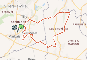
Trail Walking of 19.2 km to be discovered at Wallonia, Walloon Brabant, Villers-la-Ville. This trail is proposed by jeangulu.
Description
Localité _ Province : Marbais _ Brabant Wallon.
Entité: Villers-la-Ville.
Carte : IGN 46/4
Point de Départ : Rue de Priesmont 59 [ 1495 ].
Organisateur : Patro Notre- Dame - Georges Vaussort
Positioning
Country:
Belgium
Region :
Wallonia
Department/Province :
Walloon Brabant
Municipality :
Villers-la-Ville
Location:
Unknown
Start:(Dec)
Start:(UTM)
608951 ; 5600805 (31U) N.
Comments
Trails nearby
![Trail Walking Villers-la-Ville - RB-Bw-10-raccourci 2 - À travers campagnes et forêts, autour des ruines d’une prestigieuse abbaye - Photo](https://media.geolcdn.com/t/375/260/ext.jpg?maxdim=2&url=https%3A%2F%2Fservices.sitytrail.com%2FGeolivesWS%2FDownloadMedia.ashx%3FTrailID%3D220359%26Media%3Db52f8a40-bd4e-4201-848f-58c9caafd869.jpg)
![Walking Walking](https://static1.geolcdn.com/sitytour/trail-icons/101.png)
RB-Bw-10-raccourci 2 - À travers campagnes et forêts, autour des ruines d’une...
Walking
Difficult
(26)
Villers-la-Ville,
Wallonia,
Walloon Brabant,
Belgium
![](/images/other/stat-length.png)
13.3 km | 16.4 km-effort
3h 44min
![](https://static1.geolcdn.com/siteimages/upload/files/16400158638029165_repeat_loop_refresh_sync_direction_icon.png)
Yes
![Trail Walking Villers-la-Ville - RB-Bw-10 - Villers-la-Ville - 2025-02-08 - Photo](https://media.geolcdn.com/t/375/260/ext.jpg?maxdim=2&url=https%3A%2F%2Fservices.sitytrail.com%2FGeolivesWS%2FDownloadMedia.ashx%3FTrailID%3D220358%26Media%3D903cc0f2-4910-43b5-bcea-92ca954ab4b4.jpg)
![Walking Walking](https://static1.geolcdn.com/sitytour/trail-icons/101.png)
RB-Bw-10 - Villers-la-Ville - 2025-02-08
Walking
Very difficult
(13)
Villers-la-Ville,
Wallonia,
Walloon Brabant,
Belgium
![](/images/other/stat-length.png)
24 km | 30 km-effort
6h 43min
![](https://static1.geolcdn.com/siteimages/upload/files/16400158638029165_repeat_loop_refresh_sync_direction_icon.png)
Yes
![Trail Walking Villers-la-Ville - RB-Bw-10 - Villers-la-Ville - Via allongement - 2025-02-08 - Photo](https://media.geolcdn.com/t/375/260/ext.jpg?maxdim=2&url=https%3A%2F%2Fservices.sitytrail.com%2FGeolivesWS%2FDownloadMedia.ashx%3FTrailID%3D179585%26Media%3D903cc0f2-4910-43b5-bcea-92ca954ab4b4.jpg)
![Walking Walking](https://static1.geolcdn.com/sitytour/trail-icons/101.png)
RB-Bw-10 - Villers-la-Ville - Via allongement - 2025-02-08
Walking
Very difficult
(6)
Villers-la-Ville,
Wallonia,
Walloon Brabant,
Belgium
![](/images/other/stat-length.png)
26 km | 32 km-effort
7h 15min
![](https://static1.geolcdn.com/siteimages/upload/files/16400158638029165_repeat_loop_refresh_sync_direction_icon.png)
Yes
![Trail Walking Genappe - Genappe - Circuit Natura 2000, des sites qui valent le détour ! - Bw03 - Photo](https://media.geolcdn.com/t/375/260/ext.jpg?maxdim=2&url=https%3A%2F%2Fservices.sitytrail.com%2FGeolivesWS%2FDownloadMedia.ashx%3FTrailID%3D356410%26Media%3D9ffde3d0-226c-45a8-b2a5-1fc6dfbe0f90.jpg)
![Walking Walking](https://static1.geolcdn.com/sitytour/trail-icons/101.png)
Genappe - Circuit Natura 2000, des sites qui valent le détour ! - Bw03
Walking
Medium
(6)
Genappe,
Wallonia,
Walloon Brabant,
Belgium
![](/images/other/stat-length.png)
7.9 km | 9.7 km-effort
2h 6min
![](https://static1.geolcdn.com/siteimages/upload/files/16400158638029165_repeat_loop_refresh_sync_direction_icon.png)
Yes
![Walking Walking](https://static1.geolcdn.com/sitytour/trail-icons/101.png)
Bérines
Walking
Easy
(1)
Villers-la-Ville,
Wallonia,
Walloon Brabant,
Belgium
![](/images/other/stat-length.png)
6.4 km | 7.5 km-effort
1h 41min
![](https://static1.geolcdn.com/siteimages/upload/files/16400158638029165_repeat_loop_refresh_sync_direction_icon.png)
Yes
![Walking Walking](https://static1.geolcdn.com/sitytour/trail-icons/101.png)
BE-Villers-la-Ville - Le Bois Pigeolet et le Châtelet - VLV 7
Walking
Easy
(1)
Villers-la-Ville,
Wallonia,
Walloon Brabant,
Belgium
![](/images/other/stat-length.png)
6.6 km | 7.8 km-effort
1h 42min
![](https://static1.geolcdn.com/siteimages/upload/files/16400158638029165_repeat_loop_refresh_sync_direction_icon.png)
Yes
![Trail Walking Villers-la-Ville - Balade forestière à Villers la Ville - Photo](https://media.geolcdn.com/t/375/260/ext.jpg?maxdim=2&url=https%3A%2F%2Fservices.sitytrail.com%2FGeolivesWS%2FDownloadMedia.ashx%3FTrailID%3D120927%26Media%3D124af64a-52e1-4866-a6e4-05b50b4835ef.JPG)
![Walking Walking](https://static1.geolcdn.com/sitytour/trail-icons/101.png)
Balade forestière à Villers la Ville
Walking
Easy
(5)
Villers-la-Ville,
Wallonia,
Walloon Brabant,
Belgium
![](/images/other/stat-length.png)
11.5 km | 14.1 km-effort
3h 0min
![](https://static1.geolcdn.com/siteimages/upload/files/16400158638029165_repeat_loop_refresh_sync_direction_icon.png)
Yes
![Walking Walking](https://static1.geolcdn.com/sitytour/trail-icons/101.png)
#230728 - Gentinnes Kongolo
Walking
Easy
(1)
Chastre,
Wallonia,
Walloon Brabant,
Belgium
![](/images/other/stat-length.png)
5 km | 5.6 km-effort
1h 16min
![](https://static1.geolcdn.com/siteimages/upload/files/16400158638029165_repeat_loop_refresh_sync_direction_icon.png)
Yes
![Trail Walking Les Bons Villers - #221021 - Mellet, Champ Chassart et Saint Fiacre - Photo](https://media.geolcdn.com/t/375/260/3aea599a-a468-40e9-9bb3-55e086e309d4.jpg&format=jpg&maxdim=2)
![Walking Walking](https://static1.geolcdn.com/sitytour/trail-icons/101.png)
#221021 - Mellet, Champ Chassart et Saint Fiacre
Walking
Medium
(1)
Les Bons Villers,
Wallonia,
Hainaut,
Belgium
![](/images/other/stat-length.png)
8.6 km | 9.3 km-effort
2h 7min
![](https://static1.geolcdn.com/siteimages/upload/files/16400158638029165_repeat_loop_refresh_sync_direction_icon.png)
Yes