


rind

JL GUILLEMOTE
User
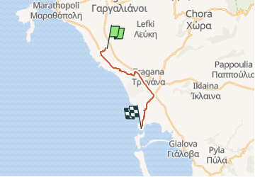

Length
11 km

Max alt
65 m

Uphill gradient
88 m
Km-Effort
12.3 km

Min alt
-3 m

Downhill gradient
141 m
Boucle
No
Creation date :
2022-09-24 13:36:02.831
Updated on :
2022-09-24 13:57:36.372
21m
Difficulty : Very easy

FREE GPS app for hiking
 SityTrail
IGN / Geographical institutes
SityTrail World
The world is yours!
About
Trail Car of 11 km to be discovered at Peloponnese, Western Greece and the Ionian, Messenia Regional Unit. This trail is proposed by JL GUILLEMOTE.
Positioning
Country:
Greece
Region :
Peloponnese, Western Greece and the Ionian
Department/Province :
Messenia Regional Unit
Municipality :
Unknown
Location:
Unknown
Start:(Dec)
Start:(UTM)
555861 ; 4098263 (34S) N.
Comments
Trails nearby