Trail Walking Osani - Girolata - Curzu - Photo

Girolata - Curzu

© OpenStreetMap contributors
Length
Length
10.3 km
Max alt
Max alt
694 m
Uphill gradient
Uphill gradient
835 m
Km-Effort
Km-Effort  
21 km
Min alt
Min alt
0 m
Downhill gradient
Downhill gradient
581 m
Boucle
Boucle
No
Creation date :
2015-11-06 00:00:00.0
Updated on :
2015-11-06 00:00:00.0

(0 Reviews)

Walking
Walking
4h40
Difficulty : Medium

Scan this QR Code to open this trail in the SityTrail application

FREE GPS app for hiking

Logo SityTrail SityTrail

IGN / Geographical institutes

Download SityTrail from the App Store Download SityTrail from Google Play

Logo SityTrail SityTrail World

The world is yours!

Download SityTrail from the App Store Download SityTrail from Google Play Download SityTrail on Huawei AppGallery

About

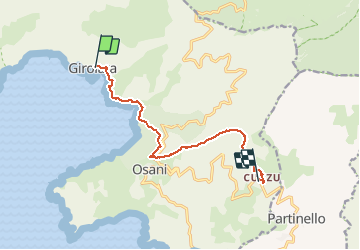
Trail Walking of 10.3 km to be discovered at Corsica, South Corsica, Osani. This trail is proposed by CorsicaNatura.

Description

De la plage, face à la mer, prendre à gauche et longer le bord de mer.
Deux chemin s’offre à vous, les deux mènent au col de la Croix.
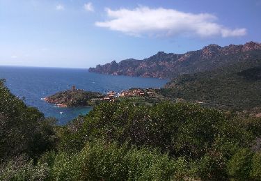
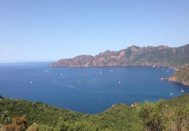
Le chemin de droite étant plus joli en passant en balcon au dessus de la mer, il monte progressivement  pour atteindre quasiment 100 mètres d’Alt., puis redescend vers la plage de Tuara. Traverser celle-ci , puis longer la paroi rocheuse vers l’amont (à gauche).
Au bout de 150 mètres, à droite, le chemin monte de nouveau. il monte progressivement dans le maquis pour atteindre le col de la Croix. «Bocca a Croce» (269 mètres) au bout de 2 Km.

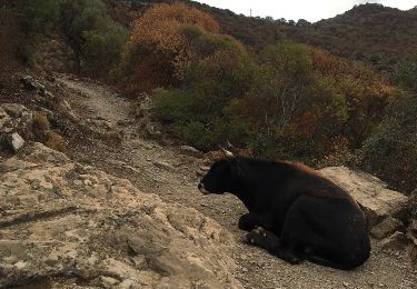
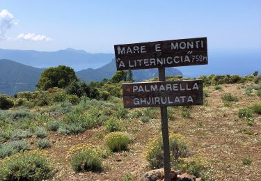
Après une petite pause rafraîchissante au col routier, le chemin Mare Monti continue tout de suite de l’autre côté de la route. Il prend direction Ouest en suivant toute la crête. Le chemin monte continuellement dans le maquis, toujours en ligne de crête; sur environ 3 Km, en atteignant 700 mètres d’Alt..
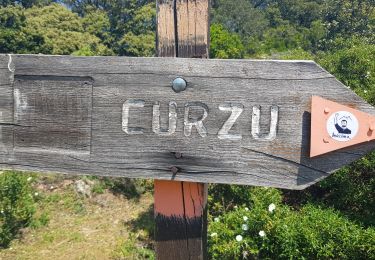
Après un grande bâtisse en ruine sur votre gauche, la descente est amorcée, Une vigilance accrue est recommandée avec des passages scabreux par endroits. le chemin prend la direction Sud et redescend vers le village de Curzu. Le village se situe à 350 mètres d’Alt.
Aux premières habitations, quitter le Mare e Monti qui continue à gauche et redescendre le village jusqu’à la route départementale D81. Lieu de Rendez-vous pour le transfert vers Piana.

Elevation profile

Positioning

Country:
France
Region :
Corsica
Department/Province :
South Corsica
Municipality :
Osani
Location:
Unknown
Start:(Dec)
Start:(UTM)
468172 ; 4688677 (32T) N.

Trails nearby

Trail Walking Osani - Girolatta - Photo
Walking
reneperrin

Walking

Easy
(1)
Osani, Corsica, South Corsica, France
10.8 km | 18.3 km-effort
3h 38min
Yes
Trail Walking Osani - Girolata par le Col de la Croix - Photo
Walking
joffrey31

Walking

Very easy
(1)
Osani, Corsica, South Corsica, France
11.2 km | 18.9 km-effort
4h 16min
Yes
Trail Other activity Osani - girolata - Photo
Other activity
GUIDE
chifmichel

Other activity

Very easy
Osani, Corsica, South Corsica, France
10.3 km | 17.7 km-effort
3h 2min
Yes
Trail Walking Osani - Corse Girolata - Photo
Walking
verolande

Walking

Medium
(1)
Osani, Corsica, South Corsica, France
9.6 km | 16.9 km-effort
3h 44min
Yes
Trail Walking Osani - Girolata Curzu - Photo
Walking
avdem

Walking

Difficult
Osani, Corsica, South Corsica, France
12.3 km | 23 km-effort
4h 49min
No
Trail Walking Osani - 20210610 de Girolata à Galeria  - Photo
Walking
ThonyM

Walking

Medium
Osani, Corsica, South Corsica, France
15.3 km | 26 km-effort
5h 10min
No
Trail Walking Osani - Rando RETOUR du Facteur de Girolata - Photo
Walking
corsinou

Walking

Very easy
(1)
Osani, Corsica, South Corsica, France
5.4 km | 10.5 km-effort
2h 18min
No
Trail Walking Osani - Rando Aller du Facteur de Girolata - Photo
Walking
corsinou

Walking

Medium
(2)
Osani, Corsica, South Corsica, France
5 km | 7.4 km-effort
1h 32min
No
Trail Walking Osani - punta castellacciu - Photo
Walking
lefoudroye

Walking

Medium
Osani, Corsica, South Corsica, France
4.5 km | 8.5 km-effort
2h 53min
Yes


Close
My subscriptions