![](/images/other/stat-length.png)
![Trail Cycle Beaufort-Orbagna - Beaufort - Photo](https://media.geolcdn.com/t/1900/400/ext.pjpeg?maxdim=2&url=https%3A%2F%2Fservices.sitytrail.com%2FGeolivesWS%2FDownloadMedia.ashx%3FTrailID%3D340022%26Media%3Dfix__20140828154155.jpg)
Beaufort
albert39
User
![Length](/images/other/stat-length.png)
Length
86 km
![Max alt](https://static1.geolcdn.com/siteimages/upload/files/1508320355ic_sort_altitude_max_24dp.png)
Max alt
550 m
![Uphill gradient](https://static1.geolcdn.com/siteimages/upload/files/1508320355ic_sort_den_pos_24dp.png)
Uphill gradient
1430 m
![Km-Effort](/images/other/stat-length.png)
Km-Effort
106 km
![Min alt](https://static1.geolcdn.com/siteimages/upload/files/1508320355ic_sort_altitude_min_24dp.png)
Min alt
190 m
![Downhill gradient](https://static1.geolcdn.com/siteimages/upload/files/1508320355ic_sort_den_neg_24dp.png)
Downhill gradient
1430 m
![Boucle](https://static1.geolcdn.com/siteimages/upload/files/16400158638029165_repeat_loop_refresh_sync_direction_icon.png)
Boucle
Yes
Creation date :
2014-12-10 00:00:00.0
Updated on :
2014-12-10 00:00:00.0
![Cycle](https://static1.geolcdn.com/sitytour/trail-icons/200.png)
5h30
Difficulty : Medium
![Scan this QR Code to open this trail in the SityTrail application](https://capi.geolives.com/qq0zvz2zws4bq2lad0pu/sitytour/trails/340022/qr.png?size=200)
FREE GPS app for hiking
About
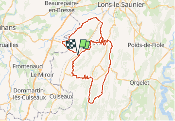
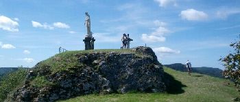
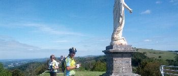
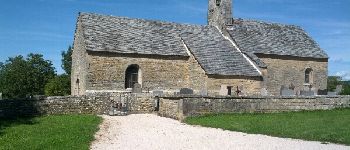
Trail Cycle of 86 km to be discovered at Bourgogne-Franche-Comté, Jura, Beaufort-Orbagna. This trail is proposed by albert39.
Description
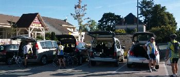
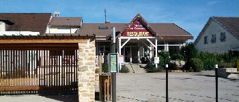
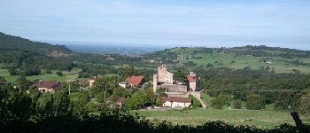
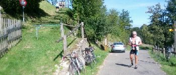
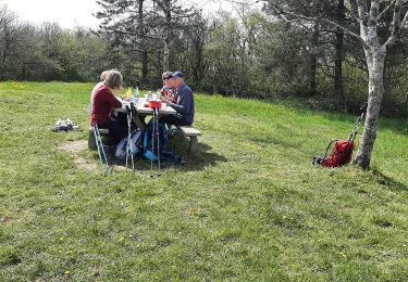
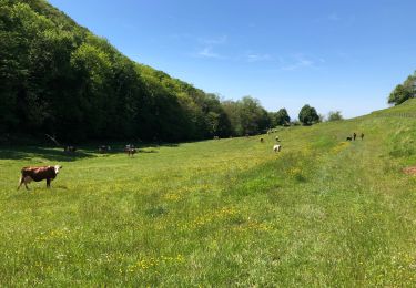
Sortie journée entre Petite Montagne et Plaine de la Bresse. Ensoleillement et chaleur pour une magnifique ballade, merci à Gérard, l'animateur ! Supère casse-croûte au resto le Revermont.
Positioning
Country:
France
Region :
Bourgogne-Franche-Comté
Department/Province :
Jura
Municipality :
Beaufort-Orbagna
Location:
Unknown
Start:(Dec)
Start:(UTM)
686651 ; 5160786 (31T) N.
Comments
Trails nearby
![Trail Walking Cousance - Cousance 20230427 - Photo](https://media.geolcdn.com/t/375/260/a43e91f6-2ecb-4982-94b8-e99248eaaa75.jpg&format=jpg&maxdim=2)
![Walking Walking](https://static1.geolcdn.com/sitytour/trail-icons/101.png)
Cousance 20230427
Walking
Very difficult
Cousance,
Bourgogne-Franche-Comté,
Jura,
France
![](/images/other/stat-length.png)
19 km | 28 km-effort
5h 3min
![](https://static1.geolcdn.com/siteimages/upload/files/16400158638029165_repeat_loop_refresh_sync_direction_icon.png)
Yes
![Trail Walking Beaufort-Orbagna - Orbagna Le Boutot La côte Chaude Rotalier Vercia Orbagna - Photo](https://media.geolcdn.com/t/375/260/ext.jpg?maxdim=2&url=https%3A%2F%2Fstatic1.geolcdn.com%2Fsiteimages%2Fupload%2Ffiles%2F1553511878bg_sport_marche.png)
![Walking Walking](https://static1.geolcdn.com/sitytour/trail-icons/101.png)
Orbagna Le Boutot La côte Chaude Rotalier Vercia Orbagna
Walking
Difficult
Beaufort-Orbagna,
Bourgogne-Franche-Comté,
Jura,
France
![](/images/other/stat-length.png)
13.4 km | 19 km-effort
4h 18min
![](https://static1.geolcdn.com/siteimages/upload/files/16400158638029165_repeat_loop_refresh_sync_direction_icon.png)
Yes
![Trail Walking Maynal - Maynal Beaufort page 129 - Photo](https://media.geolcdn.com/t/375/260/ext.jpg?maxdim=2&url=https%3A%2F%2Fstatic1.geolcdn.com%2Fsiteimages%2Fupload%2Ffiles%2F1553511878bg_sport_marche.png)
![Walking Walking](https://static1.geolcdn.com/sitytour/trail-icons/101.png)
Maynal Beaufort page 129
Walking
Difficult
Maynal,
Bourgogne-Franche-Comté,
Jura,
France
![](/images/other/stat-length.png)
16.2 km | 22 km-effort
5h 30min
![](https://static1.geolcdn.com/siteimages/upload/files/16400158638029165_repeat_loop_refresh_sync_direction_icon.png)
Yes
![Trail Walking Cuisia - Cuisia, Petite & Gde Biolée, Rosay, Chevreaux - Photo](https://media.geolcdn.com/t/375/260/ext.jpg?maxdim=2&url=https%3A%2F%2Fstatic1.geolcdn.com%2Fsiteimages%2Fupload%2Ffiles%2F1553511878bg_sport_marche.png)
![Walking Walking](https://static1.geolcdn.com/sitytour/trail-icons/101.png)
Cuisia, Petite & Gde Biolée, Rosay, Chevreaux
Walking
Difficult
Cuisia,
Bourgogne-Franche-Comté,
Jura,
France
![](/images/other/stat-length.png)
22 km | 31 km-effort
6h 32min
![](https://static1.geolcdn.com/siteimages/upload/files/16400158638029165_repeat_loop_refresh_sync_direction_icon.png)
Yes
![Trail Walking Beaufort-Orbagna - Orbagna, Combe de Rotalier, Crève-Coeur - Photo](https://media.geolcdn.com/t/375/260/ext.jpg?maxdim=2&url=https%3A%2F%2Fstatic1.geolcdn.com%2Fsiteimages%2Fupload%2Ffiles%2F1553511878bg_sport_marche.png)
![Walking Walking](https://static1.geolcdn.com/sitytour/trail-icons/101.png)
Orbagna, Combe de Rotalier, Crève-Coeur
Walking
Easy
Beaufort-Orbagna,
Bourgogne-Franche-Comté,
Jura,
France
![](/images/other/stat-length.png)
14.9 km | 21 km-effort
3h 34min
![](https://static1.geolcdn.com/siteimages/upload/files/16400158638029165_repeat_loop_refresh_sync_direction_icon.png)
Yes
![Trail Walking Beaufort-Orbagna - Crève Coeur variante. - Photo](https://media.geolcdn.com/t/375/260/6f2d9da5-745f-4ce6-b1b7-4343e24606fc.jpg&format=jpg&maxdim=2)
![Walking Walking](https://static1.geolcdn.com/sitytour/trail-icons/101.png)
Crève Coeur variante.
Walking
Very easy
Beaufort-Orbagna,
Bourgogne-Franche-Comté,
Jura,
France
![](/images/other/stat-length.png)
6.2 km | 8.9 km-effort
2h 4min
![](https://static1.geolcdn.com/siteimages/upload/files/16400158638029165_repeat_loop_refresh_sync_direction_icon.png)
Yes
![Trail Walking Maynal - aaaaaaaa - Photo](https://media.geolcdn.com/t/375/260/ext.jpg?maxdim=2&url=https%3A%2F%2Fstatic1.geolcdn.com%2Fsiteimages%2Fupload%2Ffiles%2F1553511878bg_sport_marche.png)
![Walking Walking](https://static1.geolcdn.com/sitytour/trail-icons/101.png)
aaaaaaaa
Walking
Easy
Maynal,
Bourgogne-Franche-Comté,
Jura,
France
![](/images/other/stat-length.png)
24 km | 30 km-effort
3h 10min
![](https://static1.geolcdn.com/siteimages/upload/files/16400158638029165_repeat_loop_refresh_sync_direction_icon.png)
No
![Trail Walking Beaufort-Orbagna - Les Rippes des Gras - Photo](https://media.geolcdn.com/t/375/260/ext.jpg?maxdim=2&url=https%3A%2F%2Fstatic1.geolcdn.com%2Fsiteimages%2Fupload%2Ffiles%2F1553511878bg_sport_marche.png)
![Walking Walking](https://static1.geolcdn.com/sitytour/trail-icons/101.png)
Les Rippes des Gras
Walking
Very easy
Beaufort-Orbagna,
Bourgogne-Franche-Comté,
Jura,
France
![](/images/other/stat-length.png)
13 km | 18.3 km-effort
3h 50min
![](https://static1.geolcdn.com/siteimages/upload/files/16400158638029165_repeat_loop_refresh_sync_direction_icon.png)
Yes
![Trail Walking Sainte-Agnès - Ste Agnès - Le Fourné Savardine - Cesancey - Photo](https://media.geolcdn.com/t/375/260/ext.jpg?maxdim=2&url=https%3A%2F%2Fstatic1.geolcdn.com%2Fsiteimages%2Fupload%2Ffiles%2F1553511878bg_sport_marche.png)
![Walking Walking](https://static1.geolcdn.com/sitytour/trail-icons/101.png)
Ste Agnès - Le Fourné Savardine - Cesancey
Walking
Easy
Sainte-Agnès,
Bourgogne-Franche-Comté,
Jura,
France
![](/images/other/stat-length.png)
10.2 km | 13.1 km-effort
2h 49min
![](https://static1.geolcdn.com/siteimages/upload/files/16400158638029165_repeat_loop_refresh_sync_direction_icon.png)
Yes
Magnifique rando vélo.