Trail Walking Heuvelland - Mont Kemmel - Photo
 Greg813
Greg813

User

© OpenStreetMap contributors
Length
Length
21 km
Max alt
Max alt
155 m
Uphill gradient
Uphill gradient
369 m
Km-Effort
Km-Effort  
26 km
Min alt
Min alt
36 m
Downhill gradient
Downhill gradient
367 m
Boucle
Boucle
Yes
Creation date :
2022-09-18 06:46:19.598
Updated on :
2022-10-21 07:41:28.402

(0 Reviews)

Walking
Walking
5h21
Difficulty : Medium

Scan this QR Code to open this trail in the SityTrail application

FREE GPS app for hiking

Logo SityTrail SityTrail

IGN / Geographical institutes

Download SityTrail from the App Store Download SityTrail from Google Play

Logo SityTrail SityTrail World

The world is yours!

Download SityTrail from the App Store Download SityTrail from Google Play Download SityTrail on Huawei AppGallery

About

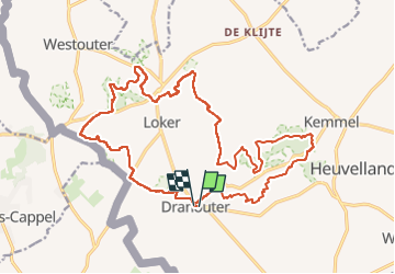
Trail Walking of 21 km to be discovered at Flanders, West Flanders, Heuvelland. This trail is proposed by Greg813.

Description

Randonnée avec Mettons le Monde en Marche au départ de Dranouter vers le Mont Kemmel.

Possibilité de diviser le parcours en 2 boucles, la partie vers le Mont Kemmel étant plus engageante physiquement (dénivelé un peu plus important).

Pour plus de photos, voir le site de l'association :
https://mmm-rando.org/randonnee-le-mont-kemmel-belgique-2022/

Elevation profile

Photos

Positioning

Country:
Belgium
Region :
Flanders
Department/Province :
West Flanders
Municipality :
Heuvelland
Location:
Dranouter
Start:(UTM)
484772 ; 5623837 (31U) N.

Trails nearby

Trail Walking Heuvelland - Loker - Le Mont Rouge - Photo
Walking
tracegps

Walking

Medium
(3)
Heuvelland, Flanders, West Flanders, Belgium
8.7 km | 10.8 km-effort
2h 19min
Yes
Trail On foot Heuvelland - Geuzen wandelroute - Photo
On foot
PRO

On foot

Easy
Heuvelland, Flanders, West Flanders, Belgium
9.7 km | 11.4 km-effort
2h 35min
Yes
Trail On foot Heuvelland - Kemmelberg wandelroute - Photo
On foot
PRO

On foot

Easy
Heuvelland, Flanders, West Flanders, Belgium
8.9 km | 11.4 km-effort
2h 36min
Yes
Trail On foot Heuvelland - Tweebergen wandelroute - Photo
On foot
PRO

On foot

Easy
Heuvelland, Flanders, West Flanders, Belgium
7.3 km | 9 km-effort
2h 2min
Yes
Trail Walking Heuvelland - Westouter langs tweetermen - Photo
Walking
Wesley Samyn

Walking

Difficult
(1)
Heuvelland, Flanders, West Flanders, Belgium
7.5 km | 9.1 km-effort
2h 4min
Yes
Trail Motor Bailleul - 104 - Photo
Motor
abalcerek

Motor

Very easy
(3)
Bailleul, Hauts-de-France, Nord, France
127 km | 140 km-effort
3h 49min
No
Trail Walking Saint-Jans-Cappel - sentier des jacynthes - Photo
Walking
Bernard.voyageur

Walking

Medium
(1)
Saint-Jans-Cappel, Hauts-de-France, Nord, France
7.3 km | 9.2 km-effort
2h 1min
Yes
Trail Walking Bailleul - camping de la Ferme des Saules à côté de Bailleul, arrivée Deulemont - Photo
Walking
jeff2

Walking

Medium
Bailleul, Hauts-de-France, Nord, France
32 km | 34 km-effort
9h 10min
No
Trail Walking Heuvelland - Dranouter 12,3 km - Photo
Walking
GUIDE
rvapeldo

Walking

Easy
Heuvelland, Flanders, West Flanders, Belgium
12.4 km | 14.5 km-effort
3h 32min
Yes


Close
My subscriptions