![](/images/other/stat-length.png)
![Trail Walking Comps-sur-Artuby - Comps-sur-Artuby Le Mauvais Pont et les Chapelles - Photo](https://media.geolcdn.com/t/1900/400/a3778514-6f82-41c8-956b-db795d23b3aa.jpg&format=pjpeg&maxdim=2)
Comps-sur-Artuby Le Mauvais Pont et les Chapelles
Chantheys
User
![Length](/images/other/stat-length.png)
Length
5.7 km
![Max alt](https://static1.geolcdn.com/siteimages/upload/files/1508320355ic_sort_altitude_max_24dp.png)
Max alt
937 m
![Uphill gradient](https://static1.geolcdn.com/siteimages/upload/files/1508320355ic_sort_den_pos_24dp.png)
Uphill gradient
187 m
![Km-Effort](/images/other/stat-length.png)
Km-Effort
8.2 km
![Min alt](https://static1.geolcdn.com/siteimages/upload/files/1508320355ic_sort_altitude_min_24dp.png)
Min alt
807 m
![Downhill gradient](https://static1.geolcdn.com/siteimages/upload/files/1508320355ic_sort_den_neg_24dp.png)
Downhill gradient
188 m
![Boucle](https://static1.geolcdn.com/siteimages/upload/files/16400158638029165_repeat_loop_refresh_sync_direction_icon.png)
Boucle
Yes
Creation date :
2022-09-18 17:06:26.589
Updated on :
2022-09-18 18:41:26.128
![Walking](https://static1.geolcdn.com/sitytour/trail-icons/101.png)
1h52
Difficulty : Medium
![Scan this QR Code to open this trail in the SityTrail application](https://capi.geolives.com/qq0zvz2zws4bq2lad0pu/sitytour/trails/3395806/qr.png?size=200)
FREE GPS app for hiking
About
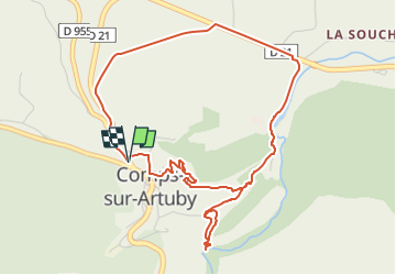
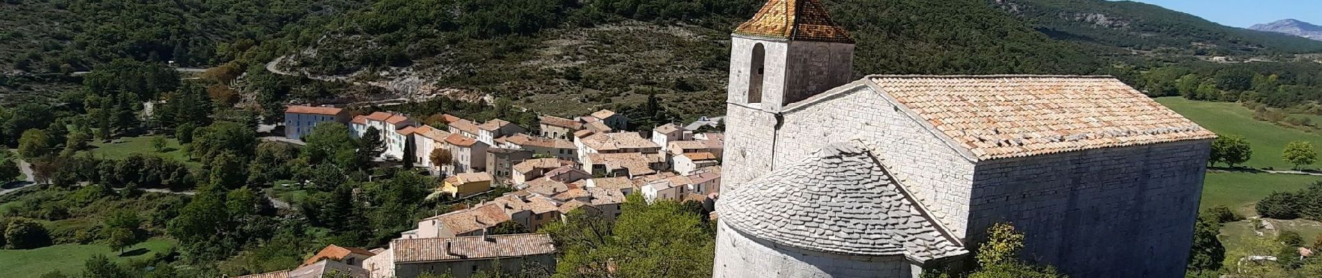
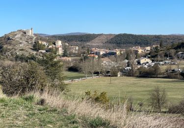
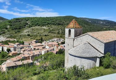
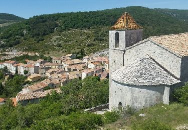
Trail Walking of 5.7 km to be discovered at Provence-Alpes-Côte d'Azur, Var, Comps-sur-Artuby. This trail is proposed by Chantheys.
Description
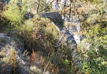
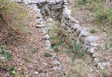
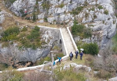
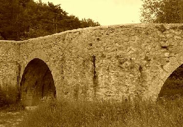
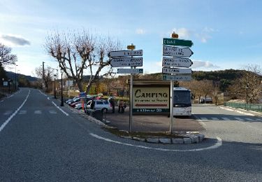
Oubliez les passages sur la D 955 et la D 21, concentrez-vous sur les paysages pour arriver sur le chemin du moulin. C'est là que la randonnée devient charmante.
Positioning
Country:
France
Region :
Provence-Alpes-Côte d'Azur
Department/Province :
Var
Municipality :
Comps-sur-Artuby
Location:
Unknown
Start:(Dec)
Start:(UTM)
299154 ; 4842744 (32T) N.
Comments
Trails nearby
![Trail Walking Bargème - bargeme pierre - Photo](https://media.geolcdn.com/t/375/260/12a20404-1c8f-4d32-b367-b86448c5a645.jpg&format=jpg&maxdim=2)
![Walking Walking](https://static1.geolcdn.com/sitytour/trail-icons/101.png)
bargeme pierre
Walking
Very easy
(1)
Bargème,
Provence-Alpes-Côte d'Azur,
Var,
France
![](/images/other/stat-length.png)
7.9 km | 11.7 km-effort
2h 40min
![](https://static1.geolcdn.com/siteimages/upload/files/16400158638029165_repeat_loop_refresh_sync_direction_icon.png)
Yes
![Trail Walking Comps-sur-Artuby - 2023-10-17 Le Fayet - Photo](https://media.geolcdn.com/t/375/260/cfec2b9f-3624-48f4-93e6-e35278188f26.jpg&format=jpg&maxdim=2)
![Walking Walking](https://static1.geolcdn.com/sitytour/trail-icons/101.png)
2023-10-17 Le Fayet
Walking
Easy
Comps-sur-Artuby,
Provence-Alpes-Côte d'Azur,
Var,
France
![](/images/other/stat-length.png)
11.8 km | 16 km-effort
3h 38min
![](https://static1.geolcdn.com/siteimages/upload/files/16400158638029165_repeat_loop_refresh_sync_direction_icon.png)
Yes
![Trail Walking Comps-sur-Artuby - Comps - Bargème - Jabron - Photo](https://media.geolcdn.com/t/375/260/4bd3e454-b69f-45b2-8b30-9c9620cfd23e.jpg&format=jpg&maxdim=2)
![Walking Walking](https://static1.geolcdn.com/sitytour/trail-icons/101.png)
Comps - Bargème - Jabron
Walking
Difficult
Comps-sur-Artuby,
Provence-Alpes-Côte d'Azur,
Var,
France
![](/images/other/stat-length.png)
24 km | 36 km-effort
6h 2min
![](https://static1.geolcdn.com/siteimages/upload/files/16400158638029165_repeat_loop_refresh_sync_direction_icon.png)
No
![Trail Walking Comps-sur-Artuby - Comps Jabron - Photo](https://media.geolcdn.com/t/375/260/926ef74f-e521-410f-97ba-753b5db351f7.jpg&format=jpg&maxdim=2)
![Walking Walking](https://static1.geolcdn.com/sitytour/trail-icons/101.png)
Comps Jabron
Walking
Very difficult
Comps-sur-Artuby,
Provence-Alpes-Côte d'Azur,
Var,
France
![](/images/other/stat-length.png)
16.6 km | 25 km-effort
4h 45min
![](https://static1.geolcdn.com/siteimages/upload/files/16400158638029165_repeat_loop_refresh_sync_direction_icon.png)
Yes
![Trail Walking Comps-sur-Artuby - De Comps-sur-Artuby à Bargème et retour - Photo](https://media.geolcdn.com/t/375/260/ext.jpg?maxdim=2&url=https%3A%2F%2Fservices.sitytrail.com%2FGeolivesWS%2FDownloadMedia.ashx%3FTrailID%3D981667%26Media%3Dfix__20180606160420.jpg)
![Walking Walking](https://static1.geolcdn.com/sitytour/trail-icons/101.png)
De Comps-sur-Artuby à Bargème et retour
Walking
Medium
Comps-sur-Artuby,
Provence-Alpes-Côte d'Azur,
Var,
France
![](/images/other/stat-length.png)
19 km | 27 km-effort
5h 44min
![](https://static1.geolcdn.com/siteimages/upload/files/16400158638029165_repeat_loop_refresh_sync_direction_icon.png)
Yes
![Trail Walking Comps-sur-Artuby - jabron bloqué par la haie métallique - Photo](https://media.geolcdn.com/t/375/260/aff6a12f-b0a5-4dc3-9339-8e641116556f.jpg&format=jpg&maxdim=2)
![Walking Walking](https://static1.geolcdn.com/sitytour/trail-icons/101.png)
jabron bloqué par la haie métallique
Walking
Difficult
Comps-sur-Artuby,
Provence-Alpes-Côte d'Azur,
Var,
France
![](/images/other/stat-length.png)
10.4 km | 16.5 km-effort
4h 56min
![](https://static1.geolcdn.com/siteimages/upload/files/16400158638029165_repeat_loop_refresh_sync_direction_icon.png)
Yes
![Trail Walking Comps-sur-Artuby - 20200614 Comps - Photo](https://media.geolcdn.com/t/375/260/20a2ad54-2c72-4bf3-abb1-5f3a7ce24694.jpg&format=jpg&maxdim=2)
![Walking Walking](https://static1.geolcdn.com/sitytour/trail-icons/101.png)
20200614 Comps
Walking
Easy
Comps-sur-Artuby,
Provence-Alpes-Côte d'Azur,
Var,
France
![](/images/other/stat-length.png)
5.1 km | 6.9 km-effort
2h 46min
![](https://static1.geolcdn.com/siteimages/upload/files/16400158638029165_repeat_loop_refresh_sync_direction_icon.png)
Yes
![Trail Walking Comps-sur-Artuby - comps sur artuby - Photo](https://media.geolcdn.com/t/375/260/ext.jpg?maxdim=2&url=https%3A%2F%2Fservices.sitytrail.com%2FGeolivesWS%2FDownloadMedia.ashx%3FTrailID%3D760709%26Media%3Dfix__20170525114828.jpg)
![Walking Walking](https://static1.geolcdn.com/sitytour/trail-icons/101.png)
comps sur artuby
Walking
Medium
Comps-sur-Artuby,
Provence-Alpes-Côte d'Azur,
Var,
France
![](/images/other/stat-length.png)
15.2 km | 21 km-effort
5h 11min
![](https://static1.geolcdn.com/siteimages/upload/files/16400158638029165_repeat_loop_refresh_sync_direction_icon.png)
Yes
![Trail Walking Comps-sur-Artuby - Comps rando Pierre - Photo](https://media.geolcdn.com/t/375/260/ext.jpg?maxdim=2&url=https%3A%2F%2Fservices.sitytrail.com%2FGeolivesWS%2FDownloadMedia.ashx%3FTrailID%3D710716%26Media%3Dfix__20170308163730.jpg)
![Walking Walking](https://static1.geolcdn.com/sitytour/trail-icons/101.png)
Comps rando Pierre
Walking
Very easy
Comps-sur-Artuby,
Provence-Alpes-Côte d'Azur,
Var,
France
![](/images/other/stat-length.png)
21 km | 29 km-effort
7h 21min
![](https://static1.geolcdn.com/siteimages/upload/files/16400158638029165_repeat_loop_refresh_sync_direction_icon.png)
Yes