![](/images/other/stat-length.png)
![Trail Walking Mettet - Oret Wagnée DEPS - Photo](https://media.geolcdn.com/t/1900/400/ext.pjpeg?maxdim=2&url=https%3A%2F%2Fstatic1.geolcdn.com%2Fsiteimages%2Fupload%2Ffiles%2F1553511878bg_sport_marche.png)
Oret Wagnée DEPS
thomarche
User
![Length](/images/other/stat-length.png)
Length
10.7 km
![Max alt](https://static1.geolcdn.com/siteimages/upload/files/1508320355ic_sort_altitude_max_24dp.png)
Max alt
277 m
![Uphill gradient](https://static1.geolcdn.com/siteimages/upload/files/1508320355ic_sort_den_pos_24dp.png)
Uphill gradient
179 m
![Km-Effort](/images/other/stat-length.png)
Km-Effort
13.1 km
![Min alt](https://static1.geolcdn.com/siteimages/upload/files/1508320355ic_sort_altitude_min_24dp.png)
Min alt
209 m
![Downhill gradient](https://static1.geolcdn.com/siteimages/upload/files/1508320355ic_sort_den_neg_24dp.png)
Downhill gradient
179 m
![Boucle](https://static1.geolcdn.com/siteimages/upload/files/16400158638029165_repeat_loop_refresh_sync_direction_icon.png)
Boucle
Yes
Creation date :
2022-09-18 11:02:28.0
Updated on :
2022-09-18 13:26:08.873
![Walking](https://static1.geolcdn.com/sitytour/trail-icons/101.png)
2h23
Difficulty : Very easy
![Scan this QR Code to open this trail in the SityTrail application](https://capi.geolives.com/qq0zvz2zws4bq2lad0pu/sitytour/trails/3395317/qr.png?size=200)
FREE GPS app for hiking
About
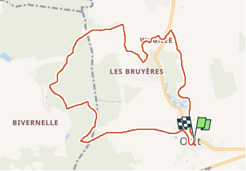
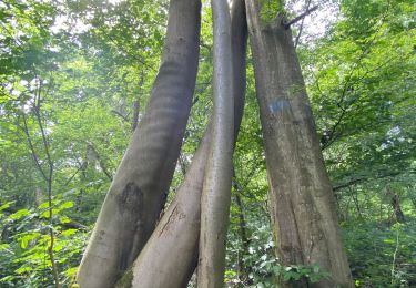
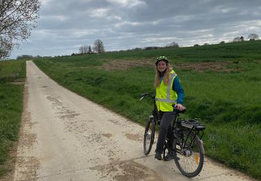
Trail Walking of 10.7 km to be discovered at Wallonia, Namur, Mettet. This trail is proposed by thomarche.
Description
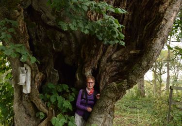
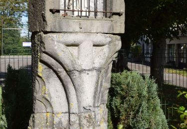
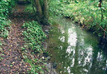
Très belle boucle à partir Centre village. Magnifiques chemins, différentes vues, bois, champs, pâtures. Très peu macadam très peu fréquenté. Et tout à fait ok par temps pluie (chemins très bien drainés)
Positioning
Country:
Belgium
Region :
Wallonia
Department/Province :
Namur
Municipality :
Mettet
Location:
Unknown
Start:(Dec)
Start:(UTM)
615148 ; 5573319 (31U) N.
Comments
Trails nearby
![Trail Walking Mettet - RB-Na-23-Sur le plateau de l’Entre-Sambre-et-Meuse - Photo](https://media.geolcdn.com/t/375/260/ext.jpg?maxdim=2&url=https%3A%2F%2Fmedia.geolcdn.com%2Ff%2F5fbb8ead-50d3-47aa-b00f-4ac497510b7f.JPG)
![Walking Walking](https://static1.geolcdn.com/sitytour/trail-icons/101.png)
RB-Na-23-Sur le plateau de l’Entre-Sambre-et-Meuse
Walking
Very difficult
(8)
Mettet,
Wallonia,
Namur,
Belgium
![](/images/other/stat-length.png)
24 km | 29 km-effort
6h 39min
![](https://static1.geolcdn.com/siteimages/upload/files/16400158638029165_repeat_loop_refresh_sync_direction_icon.png)
Yes
![Trail Walking Mettet - RB-Na-23-racc-Sur le plateau de l’Entre-Sambre-et-Meuse - Photo](https://media.geolcdn.com/t/375/260/ext.jpg?maxdim=2&url=https%3A%2F%2Fmedia.geolcdn.com%2Ff%2F4a23ab11-4064-4481-945b-ca937cc46bf3.JPG)
![Walking Walking](https://static1.geolcdn.com/sitytour/trail-icons/101.png)
RB-Na-23-racc-Sur le plateau de l’Entre-Sambre-et-Meuse
Walking
Difficult
(8)
Mettet,
Wallonia,
Namur,
Belgium
![](/images/other/stat-length.png)
14 km | 16.7 km-effort
3h 47min
![](https://static1.geolcdn.com/siteimages/upload/files/16400158638029165_repeat_loop_refresh_sync_direction_icon.png)
Yes
![Trail Walking Florennes - RB-Na-15 Campagnes et forêts de l’Entre-Sambre-et-Meuse - Photo](https://media.geolcdn.com/t/375/260/ext.jpg?maxdim=2&url=https%3A%2F%2Fservices.sitytrail.com%2FGeolivesWS%2FDownloadMedia.ashx%3FTrailID%3D179641%26Media%3Dcd0eccee-617e-4840-aac3-bf752b2b2900.jpg)
![Walking Walking](https://static1.geolcdn.com/sitytour/trail-icons/101.png)
RB-Na-15 Campagnes et forêts de l’Entre-Sambre-et-Meuse
Walking
Easy
(7)
Florennes,
Wallonia,
Namur,
Belgium
![](/images/other/stat-length.png)
23 km | 27 km-effort
5h 59min
![](https://static1.geolcdn.com/siteimages/upload/files/16400158638029165_repeat_loop_refresh_sync_direction_icon.png)
Yes
![Trail Walking Gerpinnes - 100 pc forestier - Photo](https://media.geolcdn.com/t/375/260/ext.jpg?maxdim=2&url=https%3A%2F%2Fmedia.geolcdn.com%2Ff%2F359c3f01-a3f3-427a-96cf-dcc1c9f53ce0.jpg)
![Walking Walking](https://static1.geolcdn.com/sitytour/trail-icons/101.png)
100 pc forestier
Walking
Difficult
(1)
Gerpinnes,
Wallonia,
Hainaut,
Belgium
![](/images/other/stat-length.png)
10.3 km | 12.7 km-effort
2h 45min
![](https://static1.geolcdn.com/siteimages/upload/files/16400158638029165_repeat_loop_refresh_sync_direction_icon.png)
Yes
![Trail Walking Gerpinnes - Fromiée Gougnies - Photo](https://media.geolcdn.com/t/375/260/ext.jpg?maxdim=2&url=https%3A%2F%2Fmedia.geolcdn.com%2Ff%2Fef7ce2cd-b00f-4437-a7f2-d9104f64e3f6.JPG)
![Walking Walking](https://static1.geolcdn.com/sitytour/trail-icons/101.png)
Fromiée Gougnies
Walking
Medium
(1)
Gerpinnes,
Wallonia,
Hainaut,
Belgium
![](/images/other/stat-length.png)
6.7 km | 8.2 km-effort
1h 40min
![](https://static1.geolcdn.com/siteimages/upload/files/16400158638029165_repeat_loop_refresh_sync_direction_icon.png)
Yes
![Trail Walking Gerpinnes - Fromiée Belle haie GR129 - Photo](https://media.geolcdn.com/t/375/260/ext.jpg?maxdim=2&url=https%3A%2F%2Fmedia.geolcdn.com%2Ff%2Fef988689-339a-488a-975c-45144631053a.jpg)
![Walking Walking](https://static1.geolcdn.com/sitytour/trail-icons/101.png)
Fromiée Belle haie GR129
Walking
Difficult
(1)
Gerpinnes,
Wallonia,
Hainaut,
Belgium
![](/images/other/stat-length.png)
7.1 km | 8.6 km-effort
1h 20min
![](https://static1.geolcdn.com/siteimages/upload/files/16400158638029165_repeat_loop_refresh_sync_direction_icon.png)
Yes
![Trail Walking Florennes - RB-Na-15 Raccourci - Campagnes et forêts de l’Entre-Sambre-et-Meuse - Photo](https://media.geolcdn.com/t/375/260/ext.jpg?maxdim=2&url=https%3A%2F%2Fservices.sitytrail.com%2FGeolivesWS%2FDownloadMedia.ashx%3FTrailID%3D213765%26Media%3Dbdd90a99-a997-460a-a12d-eae6fea055d6.jpg)
![Walking Walking](https://static1.geolcdn.com/sitytour/trail-icons/101.png)
RB-Na-15 Raccourci - Campagnes et forêts de l’Entre-Sambre-et-Meuse
Walking
Very easy
(3)
Florennes,
Wallonia,
Namur,
Belgium
![](/images/other/stat-length.png)
13.8 km | 16.5 km-effort
3h 27min
![](https://static1.geolcdn.com/siteimages/upload/files/16400158638029165_repeat_loop_refresh_sync_direction_icon.png)
Yes
![Trail Road bike Gerpinnes - Biesme-Prée-Wagnèe-Mettet-Oret et retour - Photo](https://media.geolcdn.com/t/375/260/ext.jpg?maxdim=2&url=https%3A%2F%2Fmedia.geolcdn.com%2Ff%2F5584c0c6-120b-437c-af02-3c7470394634.jpg)
![Road bike Road bike](https://static1.geolcdn.com/sitytour/trail-icons/201.png)
Biesme-Prée-Wagnèe-Mettet-Oret et retour
Road bike
(1)
Gerpinnes,
Wallonia,
Hainaut,
Belgium
![](/images/other/stat-length.png)
18.8 km | 22 km-effort
1h 30min
![](https://static1.geolcdn.com/siteimages/upload/files/16400158638029165_repeat_loop_refresh_sync_direction_icon.png)
Yes
![Trail Walking Florennes - D'Hanzinelle à Thy-le-Bauduin par la vallée de la Thyria - Photo](https://media.geolcdn.com/t/375/260/ext.jpg?maxdim=2&url=https%3A%2F%2Fstatic1.geolcdn.com%2Fsiteimages%2Fupload%2Ffiles%2F1553511878bg_sport_marche.png)
![Walking Walking](https://static1.geolcdn.com/sitytour/trail-icons/101.png)
D'Hanzinelle à Thy-le-Bauduin par la vallée de la Thyria
Walking
Easy
(2)
Florennes,
Wallonia,
Namur,
Belgium
![](/images/other/stat-length.png)
13.5 km | 16.7 km-effort
3h 20min
![](https://static1.geolcdn.com/siteimages/upload/files/16400158638029165_repeat_loop_refresh_sync_direction_icon.png)
Yes