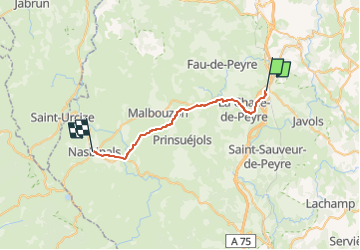
![](/images/other/stat-length.png)
![Trail Walking Peyre en Aubrac - J1 réel - Aumont-Aubrac à Nasbinals 25 890m +529m - Photo](https://media.geolcdn.com/t/1900/400/ext.pjpeg?maxdim=2&url=https%3A%2F%2Fstatic1.geolcdn.com%2Fsiteimages%2Fupload%2Ffiles%2F1553511878bg_sport_marche.png)
J1 réel - Aumont-Aubrac à Nasbinals 25 890m +529m
DanielROLLET
User
![Length](/images/other/stat-length.png)
![Max alt](https://static1.geolcdn.com/siteimages/upload/files/1508320355ic_sort_altitude_max_24dp.png)
![Uphill gradient](https://static1.geolcdn.com/siteimages/upload/files/1508320355ic_sort_den_pos_24dp.png)
![Km-Effort](/images/other/stat-length.png)
![Min alt](https://static1.geolcdn.com/siteimages/upload/files/1508320355ic_sort_altitude_min_24dp.png)
![Downhill gradient](https://static1.geolcdn.com/siteimages/upload/files/1508320355ic_sort_den_neg_24dp.png)
![Boucle](https://static1.geolcdn.com/siteimages/upload/files/16400158638029165_repeat_loop_refresh_sync_direction_icon.png)
![Walking](https://static1.geolcdn.com/sitytour/trail-icons/101.png)
6h50
Difficulty : Medium
![Scan this QR Code to open this trail in the SityTrail application](https://capi.geolives.com/qq0zvz2zws4bq2lad0pu/sitytour/trails/3389523/qr.png?size=200)
FREE GPS app for hiking
About
Trail Walking of 26 km to be discovered at Occitania, Lozère, Peyre en Aubrac. This trail is proposed by DanielROLLET.
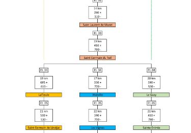
Description
2022 09 13 - GR65
Départ de l'hôtel Prunières
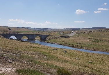
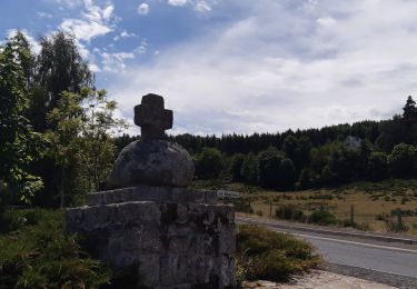
Étape sur le chemin de Compostelle
L’Aubrac s'est vraiment révélé après le hameau des "Quatre chemins"
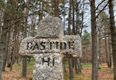
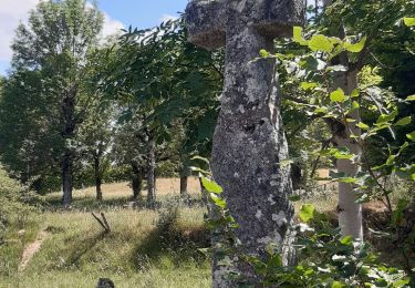
Clôtures de chaque côté du chemin tout le long du parcours
Quelques gouttes en arrivant à l'hôtel de France
8h00 à 14h50 Etape relativement facile
Positioning
Comments
Trails nearby
![Trail Walking Peyre en Aubrac - Aumont Aubrac Nasbinal Avril 2018 - Photo](https://media.geolcdn.com/t/375/260/ext.jpg?maxdim=2&url=https%3A%2F%2Fservices.sitytrail.com%2FGeolivesWS%2FDownloadMedia.ashx%3FTrailID%3D954976%26Media%3Dfix__20180420140045.jpg)
![Walking Walking](https://static1.geolcdn.com/sitytour/trail-icons/101.png)
Walking
![](/images/other/stat-length.png)
![](https://static1.geolcdn.com/siteimages/upload/files/16400158638029165_repeat_loop_refresh_sync_direction_icon.png)
![Trail Walking Peyre en Aubrac - Compostelle Aumont-Nasbinals - Photo](https://media.geolcdn.com/t/375/260/ext.jpg?maxdim=2&url=https%3A%2F%2Fstatic1.geolcdn.com%2Fsiteimages%2Fupload%2Ffiles%2F1553511878bg_sport_marche.png)
![Walking Walking](https://static1.geolcdn.com/sitytour/trail-icons/101.png)
Walking
![](/images/other/stat-length.png)
![](https://static1.geolcdn.com/siteimages/upload/files/16400158638029165_repeat_loop_refresh_sync_direction_icon.png)
![Trail Walking Peyre en Aubrac - Lasbros - Photo](https://media.geolcdn.com/t/375/260/c0f2421e-e54c-492c-b4c7-7d17496731f8.jpg&format=jpg&maxdim=2)
![Walking Walking](https://static1.geolcdn.com/sitytour/trail-icons/101.png)
Walking
![](/images/other/stat-length.png)
![](https://static1.geolcdn.com/siteimages/upload/files/16400158638029165_repeat_loop_refresh_sync_direction_icon.png)
![Trail Walking Peyre en Aubrac - Étape 1 Saint Gilhem - Photo](https://media.geolcdn.com/t/375/260/2d822680-c426-4c5d-a29b-3495a4f31f4e.jpg&format=jpg&maxdim=2)
![Walking Walking](https://static1.geolcdn.com/sitytour/trail-icons/101.png)
Walking
![](/images/other/stat-length.png)
![](https://static1.geolcdn.com/siteimages/upload/files/16400158638029165_repeat_loop_refresh_sync_direction_icon.png)
![Trail Walking Peyre en Aubrac - Mon chemin de St Guilhem étape 1 - Photo](https://media.geolcdn.com/t/375/260/6d064fd1-514a-4cb7-a19e-2096a1e7542e.jpg&format=jpg&maxdim=2)
![Walking Walking](https://static1.geolcdn.com/sitytour/trail-icons/101.png)
Walking
![](/images/other/stat-length.png)
![](https://static1.geolcdn.com/siteimages/upload/files/16400158638029165_repeat_loop_refresh_sync_direction_icon.png)
![Trail Walking Peyre en Aubrac - les moulins? - Photo](https://media.geolcdn.com/t/375/260/2e35156a-9dac-4c6e-b0c4-947bc48e0da2.jpg&format=jpg&maxdim=2)
![Walking Walking](https://static1.geolcdn.com/sitytour/trail-icons/101.png)
Walking
![](/images/other/stat-length.png)
![](https://static1.geolcdn.com/siteimages/upload/files/16400158638029165_repeat_loop_refresh_sync_direction_icon.png)
![Trail Walking Peyre en Aubrac - le rocher du Cher - Photo](https://media.geolcdn.com/t/375/260/521b0f14-15fb-43d0-a0a1-e5e04c239576.jpg&format=jpg&maxdim=2)
![Walking Walking](https://static1.geolcdn.com/sitytour/trail-icons/101.png)
Walking
![](/images/other/stat-length.png)
![](https://static1.geolcdn.com/siteimages/upload/files/16400158638029165_repeat_loop_refresh_sync_direction_icon.png)
![Trail Car Peyre en Aubrac - javols - Photo](https://media.geolcdn.com/t/375/260/88751dea-9888-4bf8-b1cf-5a47c42c86ef.jpg&format=jpg&maxdim=2)
![Car Car](https://static1.geolcdn.com/sitytour/trail-icons/401.png)
![Trail Walking Peyre en Aubrac - Chemin de St Guilhem - Variante N° 03 - Photo](https://media.geolcdn.com/t/375/260/5bf276c2-8829-4a43-964f-b59caa08d971.jpg&format=jpg&maxdim=2)
![Walking Walking](https://static1.geolcdn.com/sitytour/trail-icons/101.png)
Walking
![](/images/other/stat-length.png)
![](https://static1.geolcdn.com/siteimages/upload/files/16400158638029165_repeat_loop_refresh_sync_direction_icon.png)