Trail Running Longué-Jumelles - Tracé Corrida de Longué 2022 - Photo

Tracé Corrida de Longué 2022

 Dam C
Dam C

User

© OpenStreetMap contributors
Length
Length
10.3 km
Max alt
Max alt
45 m
Uphill gradient
Uphill gradient
116 m
Km-Effort
Km-Effort  
11.8 km
Min alt
Min alt
23 m
Downhill gradient
Downhill gradient
105 m
Boucle
Boucle
No
Creation date :
2022-09-08 19:39:32.021
Updated on :
2022-09-08 21:00:26.597

(0 Reviews)

Running
Running
32m
Difficulty : Easy

Scan this QR Code to open this trail in the SityTrail application

FREE GPS app for hiking

Logo SityTrail SityTrail

IGN / Geographical institutes

Download SityTrail from the App Store Download SityTrail from Google Play

Logo SityTrail SityTrail World

The world is yours!

Download SityTrail from the App Store Download SityTrail from Google Play Download SityTrail on Huawei AppGallery

About

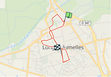
Trail Running of 10.3 km to be discovered at Pays de la Loire, Maine-et-Loire, Longué-Jumelles. This trail is proposed by Dam C.

Description

Tracé labellisé 10km qualificatif.
Course semi nocturne le 26 décembre 2022 à 18h00

Elevation profile

Positioning

Country:
France
Region :
Pays de la Loire
Department/Province :
Maine-et-Loire
Municipality :
Longué-Jumelles
Location:
Unknown
Start:(UTM)
718138 ; 5251564 (30T) N.

Trails nearby

Trail Walking Turquant - Turquant - GR3 GRP Dampierre-sur-Loire - 24.5km 320m 5h25 (1h05) - 2024 09 18 - Photo
Walking
GUIDE
Orcal37

Walking

Medium
Turquant, Pays de la Loire, Maine-et-Loire, France
24 km | 29 km-effort
5h 25min
Yes
Trail Walking Montsoreau - Montsoreau - Candes-Saint-Martin Fontevraud-l'Abbaye - 24.4km 435m 5h40 (45mn) - 2024 07 14 - Photo
Walking
GUIDE
Orcal37

Walking

Medium
Montsoreau, Pays de la Loire, Maine-et-Loire, France
24 km | 30 km-effort
5h 40min
Yes
Trail Walking Montsoreau - Montsoreau - GR3 Turquant Parnay Souzay - 15km 185m 3h30 - 2023 10 01 - Photo
Walking
GUIDE
Orcal37

Walking

Medium
Montsoreau, Pays de la Loire, Maine-et-Loire, France
15 km | 17.5 km-effort
3h 30min
Yes
Trail Walking Candes-Saint-Martin - Candes-Saint-Martin - Montsoreau GR3 - 9.6km 140m 2h25 (40mn) - 2023 10 01 - Photo
Walking
GUIDE
Orcal37

Walking

Medium
Candes-Saint-Martin, Centre-Loire Valley, Indre-et-Loire, France
9.6 km | 11.5 km-effort
2h 25min
Yes
Trail Walking Chouzé-sur-Loire - Chouzé-sur-Loire - PRs Varennes-sur-Loire - 23.9km 130m 5h35 (40mn) - 2023 05 08 - Photo
Walking
GUIDE
Orcal37

Walking

Easy
Chouzé-sur-Loire, Centre-Loire Valley, Indre-et-Loire, France
24 km | 26 km-effort
5h 35min
Yes
Trail On foot Gennes-Val-de-Loire - De Loire et Forêt - Photo
On foot
GUIDE+

On foot

Easy
Gennes-Val-de-Loire, Pays de la Loire, Maine-et-Loire, France
7.4 km | 9.1 km-effort
2h 4min
Yes
Trail On foot Baugé-en-Anjou - Circuit d’interprétation « Les Essarts » - Photo
On foot
GUIDE+

On foot

Easy
Baugé-en-Anjou, Pays de la Loire, Maine-et-Loire, France
13.5 km | 15.7 km-effort
3h 34min
Yes
Trail On foot Baugé-en-Anjou - Circuit d’interprétation « La Butte de Rancan » - Photo
On foot
GUIDE+

On foot

Easy
Baugé-en-Anjou, Pays de la Loire, Maine-et-Loire, France
4.7 km | 5.7 km-effort
1h 18min
Yes
Trail Walking Saint-Nicolas-de-Bourgueil - Saint Nicolas de Bourgueil  : La forêt et les vignes - Photo
Walking
tnayurb

Walking

Medium
(1)
Saint-Nicolas-de-Bourgueil, Centre-Loire Valley, Indre-et-Loire, France
14.8 km | 17.7 km-effort
4h 0min
Yes


Close
My subscriptions