Trail Mountain bike Belvèze-du-Razès - le tour du razes - Photo
 leroj73
leroj73

User

© OpenStreetMap contributors
Length
Length
29 km
Max alt
Max alt
351 m
Uphill gradient
Uphill gradient
492 m
Km-Effort
Km-Effort  
35 km
Min alt
Min alt
195 m
Downhill gradient
Downhill gradient
493 m
Boucle
Boucle
Yes
Creation date :
2022-09-07 17:35:00.623
Updated on :
2022-09-07 17:34:58.129

(0 Reviews)

Mountain bike
Mountain bike
2h00
Difficulty : Medium

Scan this QR Code to open this trail in the SityTrail application

FREE GPS app for hiking

Logo SityTrail SityTrail

IGN / Geographical institutes

Download SityTrail from the App Store Download SityTrail from Google Play

Logo SityTrail SityTrail World

The world is yours!

Download SityTrail from the App Store Download SityTrail from Google Play Download SityTrail on Huawei AppGallery

About

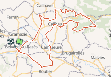
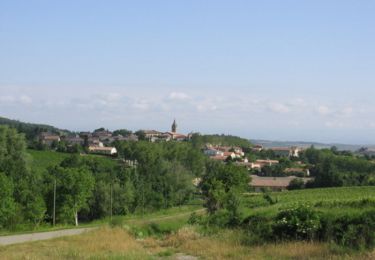
Trail Mountain bike of 29 km to be discovered at Occitania, Aude, Belvèze-du-Razès. This trail is proposed by leroj73.

Description

circuit pour sortie familiale

Elevation profile

Positioning

Country:
France
Region :
Occitania
Department/Province :
Aude
Municipality :
Belvèze-du-Razès
Location:
Unknown
Start:(UTM)
426247 ; 4775266 (31T) N.

Trails nearby

Trail Horseback riding Belvèze-du-Razès - Tour du Razès - Photo
Horseback riding
Dom4i

Horseback riding

Very difficult
(1)
Belvèze-du-Razès, Occitania, Aude, France
40 km | 52 km-effort
6h 47min
Yes
Trail On foot Ferran - À travers Champs et Vignes - Photo
On foot
GUIDE+

On foot

Medium
Ferran, Occitania, Aude, France
17.2 km | 21 km-effort
4h 49min
Yes
Trail Walking Cailhau - papillon cailhau - Photo
Walking
obriet

Walking

Very easy
Cailhau, Occitania, Aude, France
9.9 km | 12 km-effort
2h 52min
Yes
Trail Cycle Belvèze-du-Razès - CCS FFC Aude en Pyrénées - Circuit n°06 - Belvèzes du Razès  - Photo
Cycle
tracegps

Cycle

Medium
Belvèze-du-Razès, Occitania, Aude, France
39 km | 47 km-effort
2h 0min
Yes
Trail Walking Belvèze-du-Razès - beleveze - Photo
Walking
Mamilaure

Walking

Easy
Belvèze-du-Razès, Occitania, Aude, France
7.7 km | 9.3 km-effort
2h 2min
Yes
Trail Walking Cailhau - Boucle au Sud de Montréal dans l'Aude - Photo
Walking
Combaut11

Walking

Medium
(1)
Cailhau, Occitania, Aude, France
9.5 km | 11.6 km-effort
2h 38min
Yes
Trail Walking Belvèze-du-Razès - Belvèze - Photo
Walking
DENNEBECQ

Walking

Easy
Belvèze-du-Razès, Occitania, Aude, France
9.7 km | 11.5 km-effort
2h 5min
Yes
Trail Walking Cailhau - papillon de Cailhau - Photo
Walking
Mascart

Walking

Easy
Cailhau, Occitania, Aude, France
10.5 km | 12.6 km-effort
3h 0min
No
Trail Walking Cailhavel - Tour autour de Cailhavel 11 - Photo
Walking
geli.henri

Walking

Medium
Cailhavel, Occitania, Aude, France
5.9 km | 7.2 km-effort
5h 17min
Yes


Close
My subscriptions