Trail 4x4 Sainte-Geneviève - Reçu 60 - Photo
© OpenStreetMap contributors
Length
Length
130 km
Max alt
Max alt
238 m
Uphill gradient
Uphill gradient
2266 m
Km-Effort
Km-Effort  
160 km
Min alt
Min alt
36 m
Downhill gradient
Downhill gradient
2264 m
Boucle
Boucle
Yes
Creation date :
2022-09-03 08:06:12.0
Updated on :
2022-09-03 17:43:19.621

(0 Reviews)

4x4
4x4
9h35
Difficulty : Unknown

Scan this QR Code to open this trail in the SityTrail application

FREE GPS app for hiking

Logo SityTrail SityTrail

IGN / Geographical institutes

Download SityTrail from the App Store Download SityTrail from Google Play

Logo SityTrail SityTrail World

The world is yours!

Download SityTrail from the App Store Download SityTrail from Google Play Download SityTrail on Huawei AppGallery

About

Trail 4x4 of 130 km to be discovered at Hauts-de-France, Oise, Sainte-Geneviève. This trail is proposed by celinem2773.

Elevation profile

Photos

Positioning

Country:
France
Region :
Hauts-de-France
Department/Province :
Oise
Municipality :
Sainte-Geneviève
Location:
Unknown
Start:(UTM)
441899 ; 5460038 (31U) N.

Trails nearby

Trail Walking Laboissière-en-Thelle - Randonnée de Laboissière-en-Thelle  - Photo
Walking
tracegps

Walking

Medium
(1)
Laboissière-en-Thelle, Hauts-de-France, Oise, France
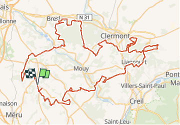
11.2 km | 13.2 km-effort
2h 49min
Yes
Trail Walking Silly-Tillard - 11- Le grand muid (partie Nord du circuit de 22km) - Photo
Walking
fitz2014

Walking

Medium
(1)
Silly-Tillard, Hauts-de-France, Oise, France
11.7 km | 14.2 km-effort
2h 55min
Yes
Trail sport Sainte-Geneviève - DIFF95 - Transoise 2019 - Photo
sport
celinem2773

sport

Very easy
(1)
Sainte-Geneviève, Hauts-de-France, Oise, France
123 km | 152 km-effort
Unknown
Yes
Trail Mountain bike Silly-Tillard - La Gauloisienne 2013  (boucle noire) - Laboissière-en-Thelle - Photo
Mountain bike
tracegps

Mountain bike

Medium
Silly-Tillard, Hauts-de-France, Oise, France
18.8 km | 23 km-effort
1h 19min
Yes
Trail Mountain bike Silly-Tillard - La Gauloisienne 2013  (boucle rouge)- Laboissière-en-Thelle  - Photo
Mountain bike
tracegps

Mountain bike

Medium
Silly-Tillard, Hauts-de-France, Oise, France
15 km | 19 km-effort
1h 10min
Yes
Trail Mountain bike Silly-Tillard - La Gauloisienne 2013 - boucle bleue - Laboissière-en-Thelle - Photo
Mountain bike
tracegps

Mountain bike

Medium
Silly-Tillard, Hauts-de-France, Oise, France
14.9 km | 18.3 km-effort
1h 0min
Yes
Trail Mountain bike Mortefontaine-en-Thelle -  La Gauloisienne 2013 - boucle verte - Mortefontaine en Thelle - Photo
Mountain bike
tracegps

Mountain bike

Medium
Mortefontaine-en-Thelle, Hauts-de-France, Oise, France
14.8 km | 17.5 km-effort
1h 0min
Yes
Trail Mountain bike Mortefontaine-en-Thelle - La Gauloisiènne 2012 - Mortefontaine en Thelle - Photo
Mountain bike
tracegps

Mountain bike

Difficult
Mortefontaine-en-Thelle, Hauts-de-France, Oise, France
72 km | 88 km-effort
5h 0min
Yes
Trail Walking Silly-Tillard - Randonnée Abbecourt - Tillard - Photo
Walking
tracegps

Walking

Medium
Silly-Tillard, Hauts-de-France, Oise, France
11.7 km | 14.2 km-effort
2h 55min
Yes


Close
My subscriptions