Trail Walking Conat - 66--Belloc : Les deux Chapelles-21/08/2014- - Photo

66--Belloc : Les deux Chapelles-21/08/2014-

 Jovila
Jovila

User

© OpenStreetMap contributors
Length
Length
12.7 km
Max alt
Max alt
1060 m
Uphill gradient
Uphill gradient
630 m
Km-Effort
Km-Effort  
21 km
Min alt
Min alt
502 m
Downhill gradient
Downhill gradient
621 m
Boucle
Boucle
Yes
Creation date :
2015-11-16 00:00:00.0
Updated on :
2015-11-16 00:00:00.0

(0 Reviews)

Walking
Walking
4h25
Difficulty : Medium

Scan this QR Code to open this trail in the SityTrail application

FREE GPS app for hiking

Logo SityTrail SityTrail

IGN / Geographical institutes

Download SityTrail from the App Store Download SityTrail from Google Play

Logo SityTrail SityTrail World

The world is yours!

Download SityTrail from the App Store Download SityTrail from Google Play Download SityTrail on Huawei AppGallery

About

Trail Walking of 12.7 km to be discovered at Occitania, Pyrénées-Orientales, Conat. This trail is proposed by Jovila.

Description

Départ : Ria direction Conat après la borne km 4 repérer la piste à gauche (2 boites aux lettres sur des briques et poubelles)ce n'est pas un chemin privé. S'engager sur ce  chemin et se garer.

Elevation profile

Points of interest

Point of interest Villefranche-de-Conflent - Point 1 - Photo
Jovila
VILLEFRANCHE-DE-CONFLENT 

Positioning

Country:
France
Region :
Occitania
Department/Province :
Pyrénées-Orientales
Municipality :
Conat
Location:
Unknown
Start:(UTM)
448062 ; 4717640 (31T) N.

Trails nearby

Trail Walking Ria-Sirach - Sirach-Taurinya-Saint Michel de Cuxa - Photo
Walking
ThonyM

Walking

Easy
(2)
Ria-Sirach, Occitania, Pyrénées-Orientales, France
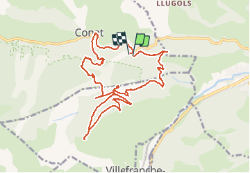
13.5 km | 17.2 km-effort
2h 31min
Yes
Trail Motor Codalet - Prades - Villefranche de Conflent - Evol  - Photo
Motor
crijack

Motor

Easy
(1)
Codalet, Occitania, Pyrénées-Orientales, France
36 km | 48 km-effort
3h 47min
No
Trail Mountain bike Ria-Sirach - cami del pi - Photo
Mountain bike
fine66

Mountain bike

Very easy
(1)
Ria-Sirach, Occitania, Pyrénées-Orientales, France
11.2 km | 18.4 km-effort
1h 52min
Yes
Trail Walking Taurinya - le Canigou depuis le col de Millères - Photo
Walking
Machaon6

Walking

Difficult
(1)
Taurinya, Occitania, Pyrénées-Orientales, France
22 km | 48 km-effort
8h 30min
Yes
Trail Walking Codalet - le tour de saint Michel de cuxià - Photo
Walking
michelle.ceres@wanadoo.fr

Walking

Medium
Codalet, Occitania, Pyrénées-Orientales, France
8.1 km | 11.1 km-effort
2h 37min
Yes
Trail Walking Codalet - Codalet /Taurinya / St Michel de cuca - Photo
Walking
robertperello

Walking

Medium
Codalet, Occitania, Pyrénées-Orientales, France
14.4 km | 21 km-effort
3h 49min
No
Trail Walking Fuilla - fuilla (66) - Photo
Walking
66Gribouille83

Walking

Difficult
Fuilla, Occitania, Pyrénées-Orientales, France
11.7 km | 17.8 km-effort
5h 57min
Yes
Trail Walking Corneilla-de-Conflent - Corneilla de Conflent - Photo
Walking
ombrabella

Walking

Easy
Corneilla-de-Conflent, Occitania, Pyrénées-Orientales, France
12.8 km | 17.7 km-effort
3h 27min
Yes
Trail Walking Catllar - cap Béarn depuis port vendres - Photo
Walking
66Gribouille83

Walking

Very difficult
Catllar, Occitania, Pyrénées-Orientales, France
111 km | 126 km-effort
49h 38min
No


Close
My subscriptions