Trail Other activity Bullet - Le tour du Chasseron - Photo
© OpenStreetMap contributors
Length
Length
31 km
Max alt
Max alt
1428 m
Uphill gradient
Uphill gradient
1273 m
Km-Effort
Km-Effort  
48 km
Min alt
Min alt
942 m
Downhill gradient
Downhill gradient
1263 m
Boucle
Boucle
Yes
Creation date :
2014-12-10 00:00:00.0
Updated on :
2014-12-10 00:00:00.0

(0 Reviews)

Other activity
Other activity
10h36
Difficulty : Unknown

Scan this QR Code to open this trail in the SityTrail application

FREE GPS app for hiking

Logo SityTrail SityTrail

IGN / Geographical institutes

Download SityTrail from the App Store Download SityTrail from Google Play

Logo SityTrail SityTrail World

The world is yours!

Download SityTrail from the App Store Download SityTrail from Google Play Download SityTrail on Huawei AppGallery

About

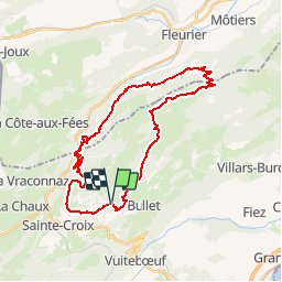
Trail Other activity of 31 km to be discovered at Vaud, District du Jura-Nord vaudois, Bullet. This trail is proposed by raetzer_th09.

Description

Bel itinéraire d''une journée dans le Jura vaudois, au départ des Rasses, où se situe un grand parking (en bas des installations de ski). Contournement du sommet du Chasseron par l''Est dans les pâturages puis descente en direction de la Motte où vous trouverez un petit refuge de forêt pour la pose de midi. Poursuivez ensuite en direction des pistes de ski de la Robellaz. Descendez dans le Vallon de Noirvaux et ouvrez l''oeil, le Grand Tétraz vous surveille! Remontez en direction du Chalet de la Maya, où une pause café, et un peu de repos pour les chevaux ,sera bienvenu. Finissez ensuite la boucle en revenant par les hauts de St-Croix.

Elevation profile

Points of interest

Point of interest Bullet - parking - Photo
raetzer_th09
BULLET 
Point of interest Val-de-Travers - pique-nique - Photo
raetzer_th09
VAL-DE-TRAVERS 
Point of interest Sainte-Croix - chalet d'alpage - Photo
raetzer_th09
SAINTE-CROIX 

Positioning

Country:
Switzerland
Region :
Vaud
Department/Province :
District du Jura-Nord vaudois
Municipality :
Bullet
Location:
Unknown
Start:(UTM)
311984 ; 5189413 (32T) N.

Trails nearby

Trail On foot La Côte-aux-Fées - La Côte-aux-Fées - Buttes - Photo
On foot
PRO

On foot

Easy
La Côte-aux-Fées, Neuchâtel, Unknown, Switzerland
6.7 km | 8.5 km-effort
1h 55min
No
Trail On foot Val-de-Travers - Petite Robella - Hôtel du Chasseron - Photo
On foot
PRO

On foot

Easy
Val-de-Travers, Neuchâtel, Unknown, Switzerland
4.5 km | 8.3 km-effort
1h 52min
No
Trail On foot Val-de-Travers - Petite Robella - Hôtel du Chasseron - Photo
On foot
PRO

On foot

Easy
Val-de-Travers, Neuchâtel, Unknown, Switzerland
4.4 km | 8.4 km-effort
1h 55min
No
Trail On foot Sainte-Croix - Sainte Croix-La Gittaz - Photo
On foot
PRO

On foot

Easy
Sainte-Croix, Vaud, District du Jura-Nord vaudois, Switzerland
5.7 km | 8.3 km-effort
1h 53min
No
Trail On foot Sainte-Croix - Chemin de la Gare - Photo
On foot
PRO

On foot

Easy
Sainte-Croix, Vaud, District du Jura-Nord vaudois, Switzerland
6.5 km | 8.6 km-effort
1h 57min
No
Trail Walking Sainte-Croix - le Chasseron par les avattes - Photo
Walking
viam19

Walking

Medium
Sainte-Croix, Vaud, District du Jura-Nord vaudois, Switzerland
13.3 km | 20 km-effort
4h 18min
Yes
Trail On foot Bullet - Les Cernets Dessous-La Combaz - Photo
On foot
PRO

On foot

Easy
Bullet, Vaud, District du Jura-Nord vaudois, Switzerland
5.7 km | 8.4 km-effort
1h 54min
No
Trail On foot Bullet - Les Cernets Dessus-Pouetta Raisse - Photo
On foot
PRO

On foot

Easy
Bullet, Vaud, District du Jura-Nord vaudois, Switzerland
6.4 km | 9.2 km-effort
2h 5min
No
Trail Snowshoes Sainte-Croix - Col des Etroits Le Chasseron CAF - Photo
Snowshoes
TRIMAILLE

Snowshoes

Difficult
Sainte-Croix, Vaud, District du Jura-Nord vaudois, Switzerland
12.2 km | 19.9 km-effort
Unknown
Yes


Close
My subscriptions