Trail Walking Notre-Dame-de-Bondeville - La Vallée du Cailly - Photo
 rvs147
rvs147

User

© OpenStreetMap contributors
Length
Length
24 km
Max alt
Max alt
155 m
Uphill gradient
Uphill gradient
424 m
Km-Effort
Km-Effort  
30 km
Min alt
Min alt
9 m
Downhill gradient
Downhill gradient
424 m
Boucle
Boucle
Yes
Creation date :
2022-09-01 08:26:45.83
Updated on :
2022-09-20 13:39:39.28

(0 Reviews)

Walking
Walking
6h50
Difficulty : Very difficult

Scan this QR Code to open this trail in the SityTrail application

FREE GPS app for hiking

Logo SityTrail SityTrail

IGN / Geographical institutes

Download SityTrail from the App Store Download SityTrail from Google Play

Logo SityTrail SityTrail World

The world is yours!

Download SityTrail from the App Store Download SityTrail from Google Play Download SityTrail on Huawei AppGallery

About

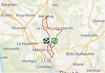
Trail Walking of 24 km to be discovered at Normandy, Seine-Maritime, Notre-Dame-de-Bondeville. This trail is proposed by rvs147.

Description

Partez à la découverte de la Vallée du Cailly, son patrimoine industriel et son tissu urbain spécifique composé essentiellement de maisons ouvrières en bandes. Le cheminement proposé parcourt la forêt Verte, notamment sur des terrains escarpés offrant ainsi des vues panoramiques, et le Bois de l’Archevêque. Le passage sur le plateau d’Houppeville permet d’observer des zones en milieu rural.

Elevation profile

Photos

Points of interest

Point of interest Notre-Dame-de-Bondeville - Départ : Gare de Maromme - Photo
rvs147
NOTRE-DAME-DE-BONDEVILLE 
Point of interest Malaunay - Point 5 : Usine Offroy - Photo
rvs147
Point of interest Notre-Dame-de-Bondeville - Point 11 : la Corderie Vallois - Photo
rvs147
NOTRE-DAME-DE-BONDEVILLE 
Point of interest Notre-Dame-de-Bondeville - Point 12 : Manoir Gresland - Photo
rvs147
NOTRE-DAME-DE-BONDEVILLE 
Point of interest Notre-Dame-de-Bondeville - Point 13 : Cheminée Gresland - Photo
rvs147
NOTRE-DAME-DE-BONDEVILLE 
Point of interest Déville-lès-Rouen - Point 16 : la halle du pont roulant - Photo
rvs147
DÉVILLE-LÈS-ROUEN 

Positioning

Country:
France
Region :
Normandy
Department/Province :
Seine-Maritime
Municipality :
Notre-Dame-de-Bondeville
Location:
Unknown
Start:(UTM)
358782 ; 5482638 (31U) N.

Trails nearby

Trail Walking Mont-Saint-Aignan - Mont-saint-aignan - Chasse-Marée -  - Photo
Walking
MichelRando7656

Walking

Difficult
(1)
Mont-Saint-Aignan, Normandy, Seine-Maritime, France
11.7 km | 15.2 km-effort
3h 27min
Yes
Trail Walking Le Houlme - 076-65-le Houlme Malaunay Canicule 9km - Photo
Walking
rvs147

Walking

Medium
(1)
Le Houlme, Normandy, Seine-Maritime, France
10 km | 13.7 km-effort
2h 56min
Yes
Trail Walking Canteleu - Canteleu - Montigny - GD - Photo
Walking
philippe76

Walking

Difficult
(1)
Canteleu, Normandy, Seine-Maritime, France
11.4 km | 13.3 km-effort
3h 0min
Yes
Trail Mountain bike Canteleu - Randonnée VTT Oxibike 2011 Canteleu 40 Kms - Photo
Mountain bike
tracegps

Mountain bike

Difficult
(1)
Canteleu, Normandy, Seine-Maritime, France
40 km | 49 km-effort
3h 0min
Yes
Trail Walking Le Houlme - 20231026-Le Houlme - Photo
Walking
doudet

Walking

Medium
Le Houlme, Normandy, Seine-Maritime, France
12 km | 15.7 km-effort
3h 29min
Yes
Trail Nordic walking Bois-Guillaume - MN - Bois-Guillaume - Bretèque - Photo
Nordic walking
philippe76

Nordic walking

Very easy
(1)
Bois-Guillaume, Normandy, Seine-Maritime, France
6.9 km | 7.9 km-effort
1h 15min
Yes
Trail Walking Houppeville - 2023-09-09_18h54m19_activity_la_breteque_2VAUbDmYip1bXIXdp2Rh75Nga7h - Photo
Walking
doudet

Walking

Difficult
Houppeville, Normandy, Seine-Maritime, France
11.3 km | 14.4 km-effort
3h 16min
Yes
Trail Walking Déville-lès-Rouen - 20230829-Déville les Rouen - Photo
Walking
doudet

Walking

Medium
Déville-lès-Rouen, Normandy, Seine-Maritime, France
11.9 km | 16.3 km-effort
3h 38min
Yes
Trail Walking Montigny - 20230711-Montigny  - Photo
Walking
doudet

Walking

Medium
Montigny, Normandy, Seine-Maritime, France
12.4 km | 16.2 km-effort
3h 37min
Yes


Close
My subscriptions