![](/images/other/stat-length.png)
![Trail Walking Bost - AVF reconnaissance Bost - Photo](https://media.geolcdn.com/t/1900/400/ext.pjpeg?maxdim=2&url=https%3A%2F%2Fstatic1.geolcdn.com%2Fsiteimages%2Fupload%2Ffiles%2F1553511878bg_sport_marche.png)
AVF reconnaissance Bost
MBMaes
User
![Length](/images/other/stat-length.png)
Length
9.9 km
![Max alt](https://static1.geolcdn.com/siteimages/upload/files/1508320355ic_sort_altitude_max_24dp.png)
Max alt
331 m
![Uphill gradient](https://static1.geolcdn.com/siteimages/upload/files/1508320355ic_sort_den_pos_24dp.png)
Uphill gradient
138 m
![Km-Effort](/images/other/stat-length.png)
Km-Effort
11.7 km
![Min alt](https://static1.geolcdn.com/siteimages/upload/files/1508320355ic_sort_altitude_min_24dp.png)
Min alt
261 m
![Downhill gradient](https://static1.geolcdn.com/siteimages/upload/files/1508320355ic_sort_den_neg_24dp.png)
Downhill gradient
137 m
![Boucle](https://static1.geolcdn.com/siteimages/upload/files/16400158638029165_repeat_loop_refresh_sync_direction_icon.png)
Boucle
Yes
Creation date :
2022-08-25 06:56:35.827
Updated on :
2022-08-28 17:39:18.694
![Walking](https://static1.geolcdn.com/sitytour/trail-icons/101.png)
2h52
Difficulty : Difficult
![Scan this QR Code to open this trail in the SityTrail application](https://capi.geolives.com/qq0zvz2zws4bq2lad0pu/sitytour/trails/3367352/qr.png?size=200)
FREE GPS app for hiking
About
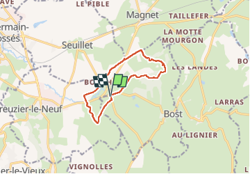
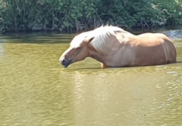
Trail Walking of 9.9 km to be discovered at Auvergne-Rhône-Alpes, Allier, Bost. This trail is proposed by MBMaes.
Description
Petite rando menée par Patrick Vichy Rando en Août 2022.
Pas grand intérêt dans le deuxième partie, mais tracé à conserver pour une rando facile AVF
Positioning
Country:
France
Region :
Auvergne-Rhône-Alpes
Department/Province :
Allier
Municipality :
Bost
Location:
Unknown
Start:(Dec)
Start:(UTM)
537698 ; 5114712 (31T) N.
Comments
Trails nearby
![Trail Walking Creuzier-le-Vieux - Circuit bleu de Creuzier-Le-Vieux - Photo](https://media.geolcdn.com/t/375/260/ext.jpg?maxdim=2&url=https%3A%2F%2Fservices.sitytrail.com%2FGeolivesWS%2FDownloadMedia.ashx%3FTrailID%3D112767%26Media%3D12154_3.jpg)
![Walking Walking](https://static1.geolcdn.com/sitytour/trail-icons/101.png)
Circuit bleu de Creuzier-Le-Vieux
Walking
Easy
(1)
Creuzier-le-Vieux,
Auvergne-Rhône-Alpes,
Allier,
France
![](/images/other/stat-length.png)
4.5 km | 5.9 km-effort
1h 10min
![](https://static1.geolcdn.com/siteimages/upload/files/16400158638029165_repeat_loop_refresh_sync_direction_icon.png)
Yes
![Trail Walking Creuzier-le-Vieux - Circuit Jaune de Creuzier Le Vieux - Photo](https://media.geolcdn.com/t/375/260/ext.jpg?maxdim=2&url=https%3A%2F%2Fservices.sitytrail.com%2FGeolivesWS%2FDownloadMedia.ashx%3FTrailID%3D112766%26Media%3D12149_4.jpg)
![Walking Walking](https://static1.geolcdn.com/sitytour/trail-icons/101.png)
Circuit Jaune de Creuzier Le Vieux
Walking
Easy
Creuzier-le-Vieux,
Auvergne-Rhône-Alpes,
Allier,
France
![](/images/other/stat-length.png)
7.2 km | 9.5 km-effort
1h 49min
![](https://static1.geolcdn.com/siteimages/upload/files/16400158638029165_repeat_loop_refresh_sync_direction_icon.png)
Yes
![Trail Walking Bost - Les Gouttes Noires - Bost - Photo](https://media.geolcdn.com/t/375/260/ext.jpg?maxdim=2&url=https%3A%2F%2Fservices.sitytrail.com%2FGeolivesWS%2FDownloadMedia.ashx%3FTrailID%3D106560%26Media%3D11131_5.jpg)
![Walking Walking](https://static1.geolcdn.com/sitytour/trail-icons/101.png)
Les Gouttes Noires - Bost
Walking
Medium
Bost,
Auvergne-Rhône-Alpes,
Allier,
France
![](/images/other/stat-length.png)
14.4 km | 18.4 km-effort
3h 34min
![](https://static1.geolcdn.com/siteimages/upload/files/16400158638029165_repeat_loop_refresh_sync_direction_icon.png)
Yes
![Trail Walking Bost - bost bof - Photo](https://media.geolcdn.com/t/375/260/2ea7e5ba-20ed-4199-8b96-a4e8082f4455.jpg&format=jpg&maxdim=2)
![Walking Walking](https://static1.geolcdn.com/sitytour/trail-icons/101.png)
bost bof
Walking
Medium
Bost,
Auvergne-Rhône-Alpes,
Allier,
France
![](/images/other/stat-length.png)
13.5 km | 17.4 km-effort
3h 43min
![](https://static1.geolcdn.com/siteimages/upload/files/16400158638029165_repeat_loop_refresh_sync_direction_icon.png)
Yes
![Trail Walking Bost - Randonnée, Les, goutte Noire, Vichy, 2023 - Photo](https://media.geolcdn.com/t/375/260/ext.jpg?maxdim=2&url=https%3A%2F%2Fstatic1.geolcdn.com%2Fsiteimages%2Fupload%2Ffiles%2F1553511878bg_sport_marche.png)
![Walking Walking](https://static1.geolcdn.com/sitytour/trail-icons/101.png)
Randonnée, Les, goutte Noire, Vichy, 2023
Walking
Medium
Bost,
Auvergne-Rhône-Alpes,
Allier,
France
![](/images/other/stat-length.png)
7.1 km | 9.7 km-effort
1h 45min
![](https://static1.geolcdn.com/siteimages/upload/files/16400158638029165_repeat_loop_refresh_sync_direction_icon.png)
Yes
![Trail Walking Creuzier-le-Vieux - Creuzier le vieux octobre 2021 - Photo](https://media.geolcdn.com/t/375/260/ext.jpg?maxdim=2&url=https%3A%2F%2Fstatic1.geolcdn.com%2Fsiteimages%2Fupload%2Ffiles%2F1553511878bg_sport_marche.png)
![Walking Walking](https://static1.geolcdn.com/sitytour/trail-icons/101.png)
Creuzier le vieux octobre 2021
Walking
Medium
Creuzier-le-Vieux,
Auvergne-Rhône-Alpes,
Allier,
France
![](/images/other/stat-length.png)
12.5 km | 16.2 km-effort
2h 55min
![](https://static1.geolcdn.com/siteimages/upload/files/16400158638029165_repeat_loop_refresh_sync_direction_icon.png)
Yes
![Trail Walking Creuzier-le-Vieux - Damien - Photo](https://media.geolcdn.com/t/375/260/ext.jpg?maxdim=2&url=https%3A%2F%2Fstatic1.geolcdn.com%2Fsiteimages%2Fupload%2Ffiles%2F1553511878bg_sport_marche.png)
![Walking Walking](https://static1.geolcdn.com/sitytour/trail-icons/101.png)
Damien
Walking
Easy
Creuzier-le-Vieux,
Auvergne-Rhône-Alpes,
Allier,
France
![](/images/other/stat-length.png)
4.7 km | 5.8 km-effort
1h 10min
![](https://static1.geolcdn.com/siteimages/upload/files/16400158638029165_repeat_loop_refresh_sync_direction_icon.png)
No
![Trail Walking Saint-Étienne-de-Vicq - La Bruyère - Saint Christophe - Photo](https://media.geolcdn.com/t/375/260/ext.jpg?maxdim=2&url=https%3A%2F%2Fstatic1.geolcdn.com%2Fsiteimages%2Fupload%2Ffiles%2F1553511878bg_sport_marche.png)
![Walking Walking](https://static1.geolcdn.com/sitytour/trail-icons/101.png)
La Bruyère - Saint Christophe
Walking
Very difficult
Saint-Étienne-de-Vicq,
Auvergne-Rhône-Alpes,
Allier,
France
![](/images/other/stat-length.png)
17.4 km | 22 km-effort
4h 46min
![](https://static1.geolcdn.com/siteimages/upload/files/16400158638029165_repeat_loop_refresh_sync_direction_icon.png)
Yes
![Trail Other activity Saint-Étienne-de-Vicq - st etienne de vicq - Photo](https://media.geolcdn.com/t/375/260/ext.jpg?maxdim=2&url=https%3A%2F%2Fstatic1.geolcdn.com%2Fsiteimages%2Fupload%2Ffiles%2F1545311037marcheuse_200dpi.jpg)
![Other activity Other activity](https://static1.geolcdn.com/sitytour/trail-icons/900.png)
st etienne de vicq
Other activity
Very easy
Saint-Étienne-de-Vicq,
Auvergne-Rhône-Alpes,
Allier,
France
![](/images/other/stat-length.png)
12.6 km | 16.7 km-effort
3h 14min
![](https://static1.geolcdn.com/siteimages/upload/files/16400158638029165_repeat_loop_refresh_sync_direction_icon.png)
Yes