![](/images/other/stat-length.png)
![Trail Walking Genappe - Hattain_0822 - Photo](https://media.geolcdn.com/t/1900/400/ext.pjpeg?maxdim=2&url=https%3A%2F%2Fmedia.geolcdn.com%2Ff%2F6516d067-b7e2-4d40-84fa-b602e1f726ed.jpg)
Hattain_0822
calofrancis
User
![Length](/images/other/stat-length.png)
Length
11.1 km
![Max alt](https://static1.geolcdn.com/siteimages/upload/files/1508320355ic_sort_altitude_max_24dp.png)
Max alt
144 m
![Uphill gradient](https://static1.geolcdn.com/siteimages/upload/files/1508320355ic_sort_den_pos_24dp.png)
Uphill gradient
174 m
![Km-Effort](/images/other/stat-length.png)
Km-Effort
13.4 km
![Min alt](https://static1.geolcdn.com/siteimages/upload/files/1508320355ic_sort_altitude_min_24dp.png)
Min alt
77 m
![Downhill gradient](https://static1.geolcdn.com/siteimages/upload/files/1508320355ic_sort_den_neg_24dp.png)
Downhill gradient
174 m
![Boucle](https://static1.geolcdn.com/siteimages/upload/files/16400158638029165_repeat_loop_refresh_sync_direction_icon.png)
Boucle
Yes
Creation date :
2022-08-23 11:43:08.48
Updated on :
2022-08-24 15:23:33.947
![Walking](https://static1.geolcdn.com/sitytour/trail-icons/101.png)
2h39
Difficulty : Medium
![Scan this QR Code to open this trail in the SityTrail application](https://capi.geolives.com/qq0zvz2zws4bq2lad0pu/sitytour/trails/3365327/qr.png?size=200)
FREE GPS app for hiking
About
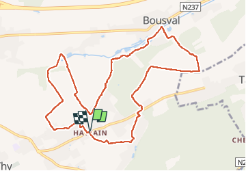
Trail Walking of 11.1 km to be discovered at Wallonia, Walloon Brabant, Genappe. This trail is proposed by calofrancis.
Description
Au départ de la place Hattain, parcours très varié, forestier, rural et patrimoine dans cette belle région de Bousval ...
guidée par : Luc Bernard
Positioning
Country:
Belgium
Region :
Wallonia
Department/Province :
Walloon Brabant
Municipality :
Genappe
Location:
Baisy-Thy
Start:(Dec)
Start:(UTM)
605514 ; 5606256 (31U) N.
Comments
Trails nearby
![Trail Walking Villers-la-Ville - RB-Bw-10-raccourci 2 - À travers campagnes et forêts, autour des ruines d’une prestigieuse abbaye - Photo](https://media.geolcdn.com/t/375/260/ext.jpg?maxdim=2&url=https%3A%2F%2Fservices.sitytrail.com%2FGeolivesWS%2FDownloadMedia.ashx%3FTrailID%3D220359%26Media%3Db52f8a40-bd4e-4201-848f-58c9caafd869.jpg)
![Walking Walking](https://static1.geolcdn.com/sitytour/trail-icons/101.png)
RB-Bw-10-raccourci 2 - À travers campagnes et forêts, autour des ruines d’une...
Walking
Difficult
(25)
Villers-la-Ville,
Wallonia,
Walloon Brabant,
Belgium
![](/images/other/stat-length.png)
13.3 km | 16.4 km-effort
3h 44min
![](https://static1.geolcdn.com/siteimages/upload/files/16400158638029165_repeat_loop_refresh_sync_direction_icon.png)
Yes
![Trail Walking Villers-la-Ville - RB-Bw-10-raccourci 1 - À travers campagnes et forêts, autour des ruines d’une prestigieuse abbaye - Photo](https://media.geolcdn.com/t/375/260/ext.jpg?maxdim=2&url=https%3A%2F%2Fservices.sitytrail.com%2FGeolivesWS%2FDownloadMedia.ashx%3FTrailID%3D220358%26Media%3Db52f8a40-bd4e-4201-848f-58c9caafd869.jpg)
![Walking Walking](https://static1.geolcdn.com/sitytour/trail-icons/101.png)
RB-Bw-10-raccourci 1 - À travers campagnes et forêts, autour des ruines d’une...
Walking
Very difficult
(12)
Villers-la-Ville,
Wallonia,
Walloon Brabant,
Belgium
![](/images/other/stat-length.png)
24 km | 30 km-effort
6h 43min
![](https://static1.geolcdn.com/siteimages/upload/files/16400158638029165_repeat_loop_refresh_sync_direction_icon.png)
Yes
![Trail Walking Genappe - RB-Bw-09 Raccourci 1 & 2 - Autour de la jeune Dyle et de ses affluents - Photo](https://media.geolcdn.com/t/375/260/ext.jpg?maxdim=2&url=https%3A%2F%2Fservices.sitytrail.com%2FGeolivesWS%2FDownloadMedia.ashx%3FTrailID%3D220340%26Media%3Dd40b4c5b-4793-41f9-ac7b-fe40a955ea25.jpg)
![Walking Walking](https://static1.geolcdn.com/sitytour/trail-icons/101.png)
RB-Bw-09 Raccourci 1 & 2 - Autour de la jeune Dyle et de ses affluents
Walking
Difficult
(11)
Genappe,
Wallonia,
Walloon Brabant,
Belgium
![](/images/other/stat-length.png)
9.7 km | 12.5 km-effort
2h 50min
![](https://static1.geolcdn.com/siteimages/upload/files/16400158638029165_repeat_loop_refresh_sync_direction_icon.png)
Yes
![Trail Walking Genappe - RB-Bw-09 Raccourci 1 - Autour de la jeune Dyle et de ses affluents - Photo](https://media.geolcdn.com/t/375/260/ext.jpg?maxdim=2&url=https%3A%2F%2Fservices.sitytrail.com%2FGeolivesWS%2FDownloadMedia.ashx%3FTrailID%3D220337%26Media%3Dcacfbcff-3084-47a0-8267-9fc97c2da542.jpg)
![Walking Walking](https://static1.geolcdn.com/sitytour/trail-icons/101.png)
RB-Bw-09 Raccourci 1 - Autour de la jeune Dyle et de ses affluents
Walking
Difficult
(11)
Genappe,
Wallonia,
Walloon Brabant,
Belgium
![](/images/other/stat-length.png)
13.2 km | 16.9 km-effort
3h 49min
![](https://static1.geolcdn.com/siteimages/upload/files/16400158638029165_repeat_loop_refresh_sync_direction_icon.png)
Yes
![Trail Walking Villers-la-Ville - RB-Bw-10 -À travers campagnes et forêts, autour des ruines d’une prestigieuse abbaye - Photo](https://media.geolcdn.com/t/375/260/ext.jpg?maxdim=2&url=https%3A%2F%2Fservices.sitytrail.com%2FGeolivesWS%2FDownloadMedia.ashx%3FTrailID%3D179585%26Media%3Db52f8a40-bd4e-4201-848f-58c9caafd869.jpg)
![Walking Walking](https://static1.geolcdn.com/sitytour/trail-icons/101.png)
RB-Bw-10 -À travers campagnes et forêts, autour des ruines d’une prestigieuse...
Walking
Very difficult
(6)
Villers-la-Ville,
Wallonia,
Walloon Brabant,
Belgium
![](/images/other/stat-length.png)
26 km | 32 km-effort
7h 15min
![](https://static1.geolcdn.com/siteimages/upload/files/16400158638029165_repeat_loop_refresh_sync_direction_icon.png)
Yes
![Trail Walking Genappe - RB-Bw-09 - Autour de la jeune Dyle et de ses affluents - Photo](https://media.geolcdn.com/t/375/260/ext.jpg?maxdim=2&url=https%3A%2F%2Fservices.sitytrail.com%2FGeolivesWS%2FDownloadMedia.ashx%3FTrailID%3D179584%26Media%3Dd40b4c5b-4793-41f9-ac7b-fe40a955ea25.jpg)
![Walking Walking](https://static1.geolcdn.com/sitytour/trail-icons/101.png)
RB-Bw-09 - Autour de la jeune Dyle et de ses affluents
Walking
Medium
(9)
Genappe,
Wallonia,
Walloon Brabant,
Belgium
![](/images/other/stat-length.png)
22 km | 28 km-effort
5h 59min
![](https://static1.geolcdn.com/siteimages/upload/files/16400158638029165_repeat_loop_refresh_sync_direction_icon.png)
Yes
![Trail Walking Genappe - Genappe - Circuit Natura 2000, des sites qui valent le détour ! - Bw03 - Photo](https://media.geolcdn.com/t/375/260/ext.jpg?maxdim=2&url=https%3A%2F%2Fservices.sitytrail.com%2FGeolivesWS%2FDownloadMedia.ashx%3FTrailID%3D356410%26Media%3D9ffde3d0-226c-45a8-b2a5-1fc6dfbe0f90.jpg)
![Walking Walking](https://static1.geolcdn.com/sitytour/trail-icons/101.png)
Genappe - Circuit Natura 2000, des sites qui valent le détour ! - Bw03
Walking
Medium
(6)
Genappe,
Wallonia,
Walloon Brabant,
Belgium
![](/images/other/stat-length.png)
7.9 km | 9.7 km-effort
2h 6min
![](https://static1.geolcdn.com/siteimages/upload/files/16400158638029165_repeat_loop_refresh_sync_direction_icon.png)
Yes
![Trail Walking Court-Saint-Étienne - GG2-Bw-22_La-Roche-Blanmont_2021-11-04 - Photo](https://media.geolcdn.com/t/375/260/ext.jpg?maxdim=2&url=https%3A%2F%2Fmedia.geolcdn.com%2Ff%2F2a6f461f-efef-416e-b536-c468aeb7dc39.jpg)
![Walking Walking](https://static1.geolcdn.com/sitytour/trail-icons/101.png)
GG2-Bw-22_La-Roche-Blanmont_2021-11-04
Walking
Medium
(2)
Court-Saint-Étienne,
Wallonia,
Walloon Brabant,
Belgium
![](/images/other/stat-length.png)
21 km | 26 km-effort
5h 51min
![](https://static1.geolcdn.com/siteimages/upload/files/16400158638029165_repeat_loop_refresh_sync_direction_icon.png)
No
![Trail Walking Villers-la-Ville - Balade forestière à Villers la Ville - Photo](https://media.geolcdn.com/t/375/260/ext.jpg?maxdim=2&url=https%3A%2F%2Fservices.sitytrail.com%2FGeolivesWS%2FDownloadMedia.ashx%3FTrailID%3D120927%26Media%3D124af64a-52e1-4866-a6e4-05b50b4835ef.JPG)
![Walking Walking](https://static1.geolcdn.com/sitytour/trail-icons/101.png)
Balade forestière à Villers la Ville
Walking
Easy
(5)
Villers-la-Ville,
Wallonia,
Walloon Brabant,
Belgium
![](/images/other/stat-length.png)
11.5 km | 14.1 km-effort
3h 0min
![](https://static1.geolcdn.com/siteimages/upload/files/16400158638029165_repeat_loop_refresh_sync_direction_icon.png)
Yes