![](/images/other/stat-length.png)
![Trail Walking Saint-Christophe-sur-Guiers - La Verchere / le Petit Som - Photo](https://media.geolcdn.com/t/1900/400/ext.pjpeg?maxdim=2&url=https%3A%2F%2Fstatic1.geolcdn.com%2Fsiteimages%2Fupload%2Ffiles%2F1553511878bg_sport_marche.png)
La Verchere / le Petit Som
Marco Paulo
User
![Length](/images/other/stat-length.png)
Length
10.7 km
![Max alt](https://static1.geolcdn.com/siteimages/upload/files/1508320355ic_sort_altitude_max_24dp.png)
Max alt
1753 m
![Uphill gradient](https://static1.geolcdn.com/siteimages/upload/files/1508320355ic_sort_den_pos_24dp.png)
Uphill gradient
699 m
![Km-Effort](/images/other/stat-length.png)
Km-Effort
20 km
![Min alt](https://static1.geolcdn.com/siteimages/upload/files/1508320355ic_sort_altitude_min_24dp.png)
Min alt
1163 m
![Downhill gradient](https://static1.geolcdn.com/siteimages/upload/files/1508320355ic_sort_den_neg_24dp.png)
Downhill gradient
703 m
![Boucle](https://static1.geolcdn.com/siteimages/upload/files/16400158638029165_repeat_loop_refresh_sync_direction_icon.png)
Boucle
Yes
Creation date :
2022-08-21 07:19:09.247
Updated on :
2022-08-21 13:29:53.892
![Walking](https://static1.geolcdn.com/sitytour/trail-icons/101.png)
4h14
Difficulty : Very difficult
![Scan this QR Code to open this trail in the SityTrail application](https://capi.geolives.com/qq0zvz2zws4bq2lad0pu/sitytour/trails/3362585/qr.png?size=200)
FREE GPS app for hiking
About
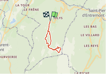
Trail Walking of 10.7 km to be discovered at Auvergne-Rhône-Alpes, Isère, Saint-Christophe-sur-Guiers. This trail is proposed by Marco Paulo.
Description
Pas de grosses difficultés mais quelques passages délicats avec un bon dénivelé avant d'atteindre le Petit Som
Positioning
Country:
France
Region :
Auvergne-Rhône-Alpes
Department/Province :
Isère
Municipality :
Saint-Christophe-sur-Guiers
Location:
Unknown
Start:(Dec)
Start:(UTM)
718879 ; 5032185 (31T) N.
Comments
Trails nearby
![Trail Snowshoes Saint-Christophe-sur-Guiers - Le Belvédère d'Arpison - Photo](https://media.geolcdn.com/t/375/260/ext.jpg?maxdim=2&url=https%3A%2F%2Fservices.sitytrail.com%2FGeolivesWS%2FDownloadMedia.ashx%3FTrailID%3D699429%26Media%3Dfix__20170216145739.jpg)
![Snowshoes Snowshoes](https://static1.geolcdn.com/sitytour/trail-icons/504.png)
Le Belvédère d'Arpison
Snowshoes
Medium
(1)
Saint-Christophe-sur-Guiers,
Auvergne-Rhône-Alpes,
Isère,
France
![](/images/other/stat-length.png)
11.1 km | 17.4 km-effort
4h 43min
![](https://static1.geolcdn.com/siteimages/upload/files/16400158638029165_repeat_loop_refresh_sync_direction_icon.png)
Yes
![Trail Walking Saint-Pierre-d'Entremont - Le Grand Som 2026m, depuis Saint-Philibert - Photo](https://media.geolcdn.com/t/375/260/ext.jpg?maxdim=2&url=https%3A%2F%2Fservices.sitytrail.com%2FGeolivesWS%2FDownloadMedia.ashx%3FTrailID%3D107472%26Media%3D12415_1.jpg)
![Walking Walking](https://static1.geolcdn.com/sitytour/trail-icons/101.png)
Le Grand Som 2026m, depuis Saint-Philibert
Walking
Difficult
(1)
Saint-Pierre-d'Entremont,
Auvergne-Rhône-Alpes,
Isère,
France
![](/images/other/stat-length.png)
11.2 km | 25 km-effort
7h 0min
![](https://static1.geolcdn.com/siteimages/upload/files/16400158638029165_repeat_loop_refresh_sync_direction_icon.png)
Yes
![Trail Walking Saint-Pierre-d'Entremont - Roche Veyrand par les Clapiers, 1429m - Photo](https://media.geolcdn.com/t/375/260/ext.jpg?maxdim=2&url=https%3A%2F%2Fservices.sitytrail.com%2FGeolivesWS%2FDownloadMedia.ashx%3FTrailID%3D101734%26Media%3D1981_1.jpg)
![Walking Walking](https://static1.geolcdn.com/sitytour/trail-icons/101.png)
Roche Veyrand par les Clapiers, 1429m
Walking
Difficult
(1)
Saint-Pierre-d'Entremont,
Auvergne-Rhône-Alpes,
Savoy,
France
![](/images/other/stat-length.png)
4.8 km | 14.3 km-effort
4h 10min
![](https://static1.geolcdn.com/siteimages/upload/files/16400158638029165_repeat_loop_refresh_sync_direction_icon.png)
Yes
![Trail Walking Saint-Christophe-sur-Guiers - Petit Som 1772m, depuis La Ruchère - Photo](https://media.geolcdn.com/t/375/260/ext.jpg?maxdim=2&url=https%3A%2F%2Fservices.sitytrail.com%2FGeolivesWS%2FDownloadMedia.ashx%3FTrailID%3D101428%26Media%3D1421_1.jpg)
![Walking Walking](https://static1.geolcdn.com/sitytour/trail-icons/101.png)
Petit Som 1772m, depuis La Ruchère
Walking
Medium
(2)
Saint-Christophe-sur-Guiers,
Auvergne-Rhône-Alpes,
Isère,
France
![](/images/other/stat-length.png)
6 km | 13.2 km-effort
3h 30min
![](https://static1.geolcdn.com/siteimages/upload/files/16400158638029165_repeat_loop_refresh_sync_direction_icon.png)
Yes
![Trail Road bike Corbel - Entreront - Photo](https://media.geolcdn.com/t/375/260/9b42e589-105e-4d70-99b0-df835d2b48ea.jpg&format=jpg&maxdim=2)
![Road bike Road bike](https://static1.geolcdn.com/sitytour/trail-icons/201.png)
Entreront
Road bike
Very difficult
(1)
Corbel,
Auvergne-Rhône-Alpes,
Savoy,
France
![](/images/other/stat-length.png)
34 km | 49 km-effort
2h 53min
![](https://static1.geolcdn.com/siteimages/upload/files/16400158638029165_repeat_loop_refresh_sync_direction_icon.png)
Yes
![Trail Walking Saint-Christophe-sur-Guiers - 38 grand som par sente intermediaire - Photo](https://media.geolcdn.com/t/375/260/d5932087-ede9-44fd-a20e-8bcb7625b7eb.jpg&format=jpg&maxdim=2)
![Walking Walking](https://static1.geolcdn.com/sitytour/trail-icons/101.png)
38 grand som par sente intermediaire
Walking
Medium
Saint-Christophe-sur-Guiers,
Auvergne-Rhône-Alpes,
Isère,
France
![](/images/other/stat-length.png)
14.5 km | 28 km-effort
7h 11min
![](https://static1.geolcdn.com/siteimages/upload/files/16400158638029165_repeat_loop_refresh_sync_direction_icon.png)
Yes
![Trail Walking Saint-Christophe - 38 st Christophe sur guiers grottes guiers vif - Photo](https://media.geolcdn.com/t/375/260/b80de980-1ba2-4651-878b-a9fe13ee8ba9.jpg&format=jpg&maxdim=2)
![Walking Walking](https://static1.geolcdn.com/sitytour/trail-icons/101.png)
38 st Christophe sur guiers grottes guiers vif
Walking
Medium
Saint-Christophe,
Auvergne-Rhône-Alpes,
Savoy,
France
![](/images/other/stat-length.png)
7.3 km | 12.7 km-effort
3h 24min
![](https://static1.geolcdn.com/siteimages/upload/files/16400158638029165_repeat_loop_refresh_sync_direction_icon.png)
Yes
![Trail Touring skiing Saint-Christophe-sur-Guiers - Col de mauvernay, de Bovinant, du Frêt et Petit Som - Photo](https://media.geolcdn.com/t/375/260/419264db-ef9b-4542-9a8f-6ba6585137b1.jpg&format=jpg&maxdim=2)
![Touring skiing Touring skiing](https://static1.geolcdn.com/sitytour/trail-icons/503.png)
Col de mauvernay, de Bovinant, du Frêt et Petit Som
Touring skiing
Medium
Saint-Christophe-sur-Guiers,
Auvergne-Rhône-Alpes,
Isère,
France
![](/images/other/stat-length.png)
12 km | 29 km-effort
6h 2min
![](https://static1.geolcdn.com/siteimages/upload/files/16400158638029165_repeat_loop_refresh_sync_direction_icon.png)
Yes
![Trail Walking Saint-Christophe-sur-Guiers - Petit Som par le Col de la Ruchère - Photo](https://media.geolcdn.com/t/375/260/ext.jpg?maxdim=2&url=https%3A%2F%2Fservices.sitytrail.com%2FGeolivesWS%2FDownloadMedia.ashx%3FTrailID%3D187990%26Media%3D84dca246-9935-47c1-bea7-9350caca3e85.JPG)
![Walking Walking](https://static1.geolcdn.com/sitytour/trail-icons/101.png)
Petit Som par le Col de la Ruchère
Walking
Medium
(2)
Saint-Christophe-sur-Guiers,
Auvergne-Rhône-Alpes,
Isère,
France
![](/images/other/stat-length.png)
7.1 km | 15.2 km-effort
3h 5min
![](https://static1.geolcdn.com/siteimages/upload/files/16400158638029165_repeat_loop_refresh_sync_direction_icon.png)
Yes