


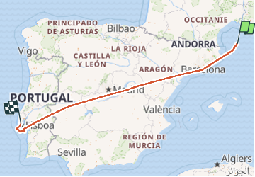
Lisbonne

aldaus
User

Length
1391 km
Boucle
No
Creation date :
2022-08-20 16:55:46.82
Updated on :
2022-08-20 19:54:40.01
2h19
Difficulty : Very easy

FREE GPS app for hiking
 SityTrail
IGN / Geographical institutes
SityTrail World
The world is yours!
About
Trail Plane of 1391 km to be discovered at . This trail is proposed by aldaus.
Photos

Positioning
Country:
Unknown
Region :
Unknown
Department/Province :
Unknown
Municipality :
Unknown
Location:
Unknown
Start:(Dec)
Start:(UTM)
606258 ; 4710275 (31T) N.
Comments
Trails nearby