![](/images/other/stat-length.png)
![Trail Other activity Grindelwald - Faulhorn en luge - Photo](https://media.geolcdn.com/t/1900/400/ext.pjpeg?maxdim=2&url=https%3A%2F%2Fstatic1.geolcdn.com%2Fsiteimages%2Fupload%2Ffiles%2F1545311037marcheuse_200dpi.jpg)
Faulhorn en luge
Dgubler
User
![Length](/images/other/stat-length.png)
![Max alt](https://static1.geolcdn.com/siteimages/upload/files/1508320355ic_sort_altitude_max_24dp.png)
![Uphill gradient](https://static1.geolcdn.com/siteimages/upload/files/1508320355ic_sort_den_pos_24dp.png)
![Km-Effort](/images/other/stat-length.png)
![Min alt](https://static1.geolcdn.com/siteimages/upload/files/1508320355ic_sort_altitude_min_24dp.png)
![Downhill gradient](https://static1.geolcdn.com/siteimages/upload/files/1508320355ic_sort_den_neg_24dp.png)
![Boucle](https://static1.geolcdn.com/siteimages/upload/files/16400158638029165_repeat_loop_refresh_sync_direction_icon.png)
![Other activity](https://static1.geolcdn.com/sitytour/trail-icons/900.png)
--
Difficulty : Unknown
![Scan this QR Code to open this trail in the SityTrail application](https://capi.geolives.com/qq0zvz2zws4bq2lad0pu/sitytour/trails/33601/qr.png?size=200)
FREE GPS app for hiking
About
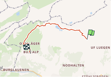
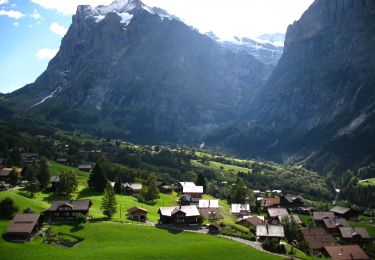
Trail Other activity of 10 km to be discovered at Bern, Interlaken-Oberhasli administrative district, Grindelwald. This trail is proposed by Dgubler.
Description
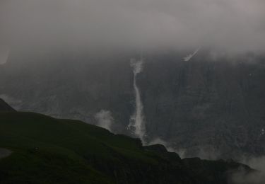
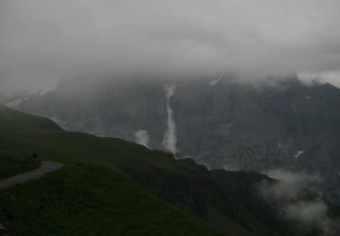
D''après l''office du tourisme de la région Junfrau, il s''agit de la plus longue randonnée en luge du monde (15 km). Nous en présentons ici 10 km (5 de montée, 5 de descente), entre First et Bussalp (le reste de la descente aurait été de la "papette").
En dénivellé: 350 m de montée, 750 m de descente.
Positioning
Comments
Trails nearby
![Trail On foot Grindelwald - CH-Abzweigung Gleckstein - Glecksteinhütte - Photo](https://media.geolcdn.com/t/375/260/ef190951-62eb-4dbd-a99b-3b81e2e5a8e3.jpeg&format=jpg&maxdim=2)
![On foot On foot](https://static1.geolcdn.com/sitytour/trail-icons/100.png)
On foot
![](/images/other/stat-length.png)
![](https://static1.geolcdn.com/siteimages/upload/files/16400158638029165_repeat_loop_refresh_sync_direction_icon.png)
![Trail On foot Grindelwald - CH-Unterlauchbühl - Bort - Photo](https://media.geolcdn.com/t/375/260/917b7bc8-fc63-4bb4-ac37-b5bc1f4152ab.jpeg&format=jpg&maxdim=2)
![On foot On foot](https://static1.geolcdn.com/sitytour/trail-icons/100.png)
On foot
![](/images/other/stat-length.png)
![](https://static1.geolcdn.com/siteimages/upload/files/16400158638029165_repeat_loop_refresh_sync_direction_icon.png)
![Trail On foot Grindelwald - First - Bachalpsee - Fauhlhorn - Schynige Platte - Photo](https://media.geolcdn.com/t/375/260/b61592a8-cb23-41ac-904f-7c76e10b8fcc.jpeg&format=jpg&maxdim=2)
![On foot On foot](https://static1.geolcdn.com/sitytour/trail-icons/100.png)
On foot
![](/images/other/stat-length.png)
![](https://static1.geolcdn.com/siteimages/upload/files/16400158638029165_repeat_loop_refresh_sync_direction_icon.png)
![Trail On foot Grindelwald - Bachalpsee - Oberläger - Faulhorn - Photo](https://media.geolcdn.com/t/375/260/f62b1a84-1970-4e32-afcd-65dd14db1ded.jpeg&format=jpg&maxdim=2)
![On foot On foot](https://static1.geolcdn.com/sitytour/trail-icons/100.png)
On foot
![](/images/other/stat-length.png)
![](https://static1.geolcdn.com/siteimages/upload/files/16400158638029165_repeat_loop_refresh_sync_direction_icon.png)
![Trail On foot Grindelwald - Holewang - fixme - Photo](https://media.geolcdn.com/t/375/260/c1fd772a-1ad4-4009-8d2b-3788115972fd.jpeg&format=jpg&maxdim=2)
![On foot On foot](https://static1.geolcdn.com/sitytour/trail-icons/100.png)
On foot
![](/images/other/stat-length.png)
![](https://static1.geolcdn.com/siteimages/upload/files/16400158638029165_repeat_loop_refresh_sync_direction_icon.png)
![Trail On foot Grindelwald - Scheidegg / Oberläger - Wildgärst - Photo](https://media.geolcdn.com/t/375/260/4689ea70-6843-4964-b7a9-fdd50bcac679.jpeg&format=jpg&maxdim=2)
![On foot On foot](https://static1.geolcdn.com/sitytour/trail-icons/100.png)
On foot
![](/images/other/stat-length.png)
![](https://static1.geolcdn.com/siteimages/upload/files/16400158638029165_repeat_loop_refresh_sync_direction_icon.png)
![Trail On foot Grindelwald - Grosse Scheidegg - Scheidegg / Oberläger - Photo](https://media.geolcdn.com/t/375/260/96ca2c08-6940-4c3a-a732-f8b809054a0a.jpeg&format=jpg&maxdim=2)
![On foot On foot](https://static1.geolcdn.com/sitytour/trail-icons/100.png)
On foot
![](/images/other/stat-length.png)
![](https://static1.geolcdn.com/siteimages/upload/files/16400158638029165_repeat_loop_refresh_sync_direction_icon.png)
![Trail On foot Grindelwald - Grosse Scheidegg - Schreckfeld - Photo](https://media.geolcdn.com/t/375/260/96ca2c08-6940-4c3a-a732-f8b809054a0a.jpeg&format=jpg&maxdim=2)
![On foot On foot](https://static1.geolcdn.com/sitytour/trail-icons/100.png)
On foot
![](/images/other/stat-length.png)
![](https://static1.geolcdn.com/siteimages/upload/files/16400158638029165_repeat_loop_refresh_sync_direction_icon.png)
![Trail On foot Grindelwald - First - Grosse Scheidegg (Höhenweg 2400) - Photo](https://media.geolcdn.com/t/375/260/96ca2c08-6940-4c3a-a732-f8b809054a0a.jpeg&format=jpg&maxdim=2)
![On foot On foot](https://static1.geolcdn.com/sitytour/trail-icons/100.png)
On foot
![](/images/other/stat-length.png)
![](https://static1.geolcdn.com/siteimages/upload/files/16400158638029165_repeat_loop_refresh_sync_direction_icon.png)