![](/images/other/stat-length.png)
![Trail Walking Unknown - Monastiri and lighthouse in Paeos - Photo](https://media.geolcdn.com/t/1900/400/f04dc56c-b587-4c02-863f-bd598b6bab77.jpg&format=pjpeg&maxdim=2)
Monastiri and lighthouse in Paeos
David Toussaint
User
![Length](/images/other/stat-length.png)
Length
33 km
![Max alt](https://static1.geolcdn.com/siteimages/upload/files/1508320355ic_sort_altitude_max_24dp.png)
Max alt
134 m
![Uphill gradient](https://static1.geolcdn.com/siteimages/upload/files/1508320355ic_sort_den_pos_24dp.png)
Uphill gradient
480 m
![Km-Effort](/images/other/stat-length.png)
Km-Effort
40 km
![Min alt](https://static1.geolcdn.com/siteimages/upload/files/1508320355ic_sort_altitude_min_24dp.png)
Min alt
-2 m
![Downhill gradient](https://static1.geolcdn.com/siteimages/upload/files/1508320355ic_sort_den_neg_24dp.png)
Downhill gradient
481 m
![Boucle](https://static1.geolcdn.com/siteimages/upload/files/16400158638029165_repeat_loop_refresh_sync_direction_icon.png)
Boucle
Yes
Creation date :
2022-08-12 07:21:29.066
Updated on :
2022-08-12 15:59:56.157
![Walking](https://static1.geolcdn.com/sitytour/trail-icons/101.png)
4h10
Difficulty : Very easy
![Scan this QR Code to open this trail in the SityTrail application](https://capi.geolives.com/qq0zvz2zws4bq2lad0pu/sitytour/trails/3352222/qr.png?size=200)
FREE GPS app for hiking
About
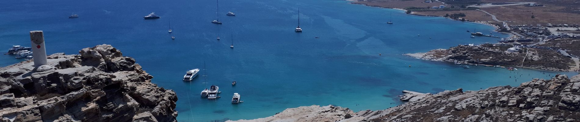
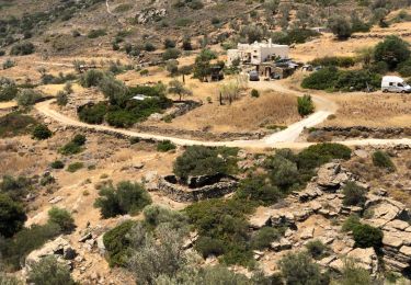
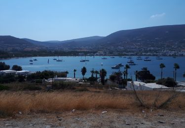
Trail Walking of 33 km to be discovered at Aegean, Paros Regional Unit. This trail is proposed by David Toussaint.
Description
from Parikya, take the bus to Naoussa, visit port and then cross the bay by boat to monastiri, take a walk to the lighthouse and other peninsula peak (100m!) and have lunch at the beach and relax in the sea bay. return with boat (every 45 minutes) and bus to Parikia.
Positioning
Country:
Greece
Region :
Aegean
Department/Province :
Paros Regional Unit
Municipality :
Unknown
Location:
Unknown
Start:(Dec)
Start:(UTM)
336168 ; 4106597 (35S) N.
Comments
Trails nearby
![Trail Walking - Kalami Parikia - Photo](https://media.geolcdn.com/t/375/260/c8bf3c73-b505-47f5-b69b-d776e309d198.jpg&format=jpg&maxdim=2)
![Walking Walking](https://static1.geolcdn.com/sitytour/trail-icons/101.png)
Kalami Parikia
Walking
Easy
,
Aegean,
Paros Regional Unit,
Greece
![](/images/other/stat-length.png)
8.5 km | 9.9 km-effort
1h 59min
![](https://static1.geolcdn.com/siteimages/upload/files/16400158638029165_repeat_loop_refresh_sync_direction_icon.png)
Yes
![Trail Walking - Lefkes Aspro Chorio par la kavouropotamos - Photo](https://media.geolcdn.com/t/375/260/ext.jpg?maxdim=2&url=https%3A%2F%2Fservices.sitytrail.com%2FGeolivesWS%2FDownloadMedia.ashx%3FTrailID%3D1005450%26Media%3D20180708122353.jpg)
![Walking Walking](https://static1.geolcdn.com/sitytour/trail-icons/101.png)
Lefkes Aspro Chorio par la kavouropotamos
Walking
Easy
,
Aegean,
Paros Regional Unit,
Greece
![](/images/other/stat-length.png)
9.2 km | 14.1 km-effort
3h 29min
![](https://static1.geolcdn.com/siteimages/upload/files/16400158638029165_repeat_loop_refresh_sync_direction_icon.png)
No
![Trail Walking - Delion sanctuary of Apollon, Paros, GR - Photo](https://media.geolcdn.com/t/375/260/a7d83864-d2c8-41e3-b32c-d5e27c04ec61.jpg&format=jpg&maxdim=2)
![Walking Walking](https://static1.geolcdn.com/sitytour/trail-icons/101.png)
Delion sanctuary of Apollon, Paros, GR
Walking
Very easy
,
Aegean,
Paros Regional Unit,
Greece
![](/images/other/stat-length.png)
5.4 km | 7.6 km-effort
1h 36min
![](https://static1.geolcdn.com/siteimages/upload/files/16400158638029165_repeat_loop_refresh_sync_direction_icon.png)
Yes
![Trail Walking - Parikia2 - Photo](https://media.geolcdn.com/t/375/260/ext.jpg?maxdim=2&url=https%3A%2F%2Fstatic1.geolcdn.com%2Fsiteimages%2Fupload%2Ffiles%2F1553511878bg_sport_marche.png)
![Walking Walking](https://static1.geolcdn.com/sitytour/trail-icons/101.png)
![Trail Car - Paros - Photo](https://media.geolcdn.com/t/375/260/ext.jpg?maxdim=2&url=https%3A%2F%2Fstatic1.geolcdn.com%2Fsiteimages%2Fupload%2Ffiles%2F15247431544x4.jpg)
![Car Car](https://static1.geolcdn.com/sitytour/trail-icons/401.png)
![Trail Walking - Parikia - Photo](https://media.geolcdn.com/t/375/260/ext.jpg?maxdim=2&url=https%3A%2F%2Fstatic1.geolcdn.com%2Fsiteimages%2Fupload%2Ffiles%2F1553511878bg_sport_marche.png)
![Walking Walking](https://static1.geolcdn.com/sitytour/trail-icons/101.png)
![Trail Motorboat - Paros Naxos Amorgos - Photo](https://media.geolcdn.com/t/375/260/ext.jpg?maxdim=2&url=https%3A%2F%2Fsecurestorage.geolives.com%2Fsitytour%2Ftrail-bg%2Fdefault.jpg)
![Motorboat Motorboat](https://static1.geolcdn.com/sitytour/trail-icons/701.png)
Paros Naxos Amorgos
Motorboat
,
Aegean,
Paros Regional Unit,
Greece
![](/images/other/stat-length.png)
118 km | 118 km-effort
4h 12min
![](https://static1.geolcdn.com/siteimages/upload/files/16400158638029165_repeat_loop_refresh_sync_direction_icon.png)
No