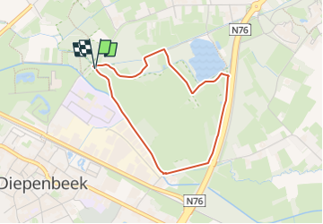
![](/images/other/stat-length.png)
![Trail Walking Diepenbeek - La vallée du Démer - La réserve naturelle Dorpsbemden à Diepenbeek - Photo](https://media.geolcdn.com/t/1900/400/831c90b3-6b69-4442-bd2d-357552ece2e5.jpeg&format=pjpeg&maxdim=2)
La vallée du Démer - La réserve naturelle Dorpsbemden à Diepenbeek
Benjamin27
User GUIDE
![Length](/images/other/stat-length.png)
![Max alt](https://static1.geolcdn.com/siteimages/upload/files/1508320355ic_sort_altitude_max_24dp.png)
![Uphill gradient](https://static1.geolcdn.com/siteimages/upload/files/1508320355ic_sort_den_pos_24dp.png)
![Km-Effort](/images/other/stat-length.png)
![Min alt](https://static1.geolcdn.com/siteimages/upload/files/1508320355ic_sort_altitude_min_24dp.png)
![Downhill gradient](https://static1.geolcdn.com/siteimages/upload/files/1508320355ic_sort_den_neg_24dp.png)
![Boucle](https://static1.geolcdn.com/siteimages/upload/files/16400158638029165_repeat_loop_refresh_sync_direction_icon.png)
![Walking](https://static1.geolcdn.com/sitytour/trail-icons/101.png)
45m
Difficulty : Easy
![Scan this QR Code to open this trail in the SityTrail application](https://capi.geolives.com/qq0zvz2zws4bq2lad0pu/sitytour/trails/3350295/qr.png?size=200)
FREE GPS app for hiking
About
Trail Walking of 3.1 km to be discovered at Flanders, Limburg, Diepenbeek. This trail is proposed by Benjamin27.
Description
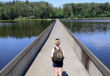
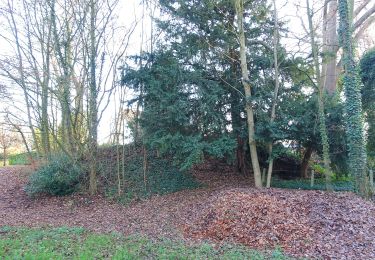
Cette jolie petite réserve naturelle vous apaisera certainement : entre la rivière Démer et les champs à perte de vue, vous profitez d’un calme absolu dans une nature qui a repris ses droits.
👣 Distance : 3,5km - balisage rectangle vert (et croix brune pour rejoindre le départ).
🗺️ Carte / Fichier GPX en bio.
📍Départ : parking Demerstrand, Stationsstraat 27 - 3590 Diepenbeek.
🚂 La promenade peut être démarrée à partir de la gare de Diepenbeek.
💡A combiner avec la promenade « Le ruisseau Dauten et les Dautewijers ».
Positioning
Comments
Trails nearby
![Trail Walking Hasselt - Domaine Kiewit &](https://media.geolcdn.com/t/375/260/24e338e2-ab75-48fb-ae32-0abbc38a1902.jpg&format=jpg&maxdim=2)
![Walking Walking](https://static1.geolcdn.com/sitytour/trail-icons/101.png)
Walking
![](/images/other/stat-length.png)
![](https://static1.geolcdn.com/siteimages/upload/files/16400158638029165_repeat_loop_refresh_sync_direction_icon.png)
![Trail Walking Genk - Promenade vers la piste dans l'eau, dans le magnifique domaine de Bokrijk - Photo](https://media.geolcdn.com/t/375/260/45cc0ed2-db94-4d5d-a7c6-1096a930a2ab.jpg&format=jpg&maxdim=2)
![Walking Walking](https://static1.geolcdn.com/sitytour/trail-icons/101.png)
Walking
![](/images/other/stat-length.png)
![](https://static1.geolcdn.com/siteimages/upload/files/16400158638029165_repeat_loop_refresh_sync_direction_icon.png)
![Trail Walking Diepenbeek - La vallée du Démer - Le ruisseau Dauten et les Dautewijers à Diepenbeek - Photo](https://media.geolcdn.com/t/375/260/ff431e14-a2e4-4401-9193-e96799f79a9a.jpeg&format=jpg&maxdim=2)
![Walking Walking](https://static1.geolcdn.com/sitytour/trail-icons/101.png)
Walking
![](/images/other/stat-length.png)
![](https://static1.geolcdn.com/siteimages/upload/files/16400158638029165_repeat_loop_refresh_sync_direction_icon.png)
![Trail On foot Diepenbeek - Lange afstandstocht - Photo](https://media.geolcdn.com/t/375/260/c0f28296-bcff-4fe2-9db4-902c2464ce24.jpeg&format=jpg&maxdim=2)
![On foot On foot](https://static1.geolcdn.com/sitytour/trail-icons/100.png)
On foot
![](/images/other/stat-length.png)
![](https://static1.geolcdn.com/siteimages/upload/files/16400158638029165_repeat_loop_refresh_sync_direction_icon.png)
![Trail On foot Hasselt - Mombeekpad W700 geel - Photo](https://media.geolcdn.com/t/375/260/d91aeff8-4d52-4b35-a08b-6ff9055d6a9b.jpeg&format=jpg&maxdim=2)
![On foot On foot](https://static1.geolcdn.com/sitytour/trail-icons/100.png)
On foot
![](/images/other/stat-length.png)
![](https://static1.geolcdn.com/siteimages/upload/files/16400158638029165_repeat_loop_refresh_sync_direction_icon.png)
![Trail On foot Diepenbeek - Dorpsbemden - Photo](https://media.geolcdn.com/t/375/260/3c4356e7-f857-471e-86d0-400db7034da1.jpeg&format=jpg&maxdim=2)
![On foot On foot](https://static1.geolcdn.com/sitytour/trail-icons/100.png)
![Trail On foot Diepenbeek - Dauteweyers - Photo](https://media.geolcdn.com/t/375/260/c0f28296-bcff-4fe2-9db4-902c2464ce24.jpeg&format=jpg&maxdim=2)
![On foot On foot](https://static1.geolcdn.com/sitytour/trail-icons/100.png)
![Trail On foot Diepenbeek - 12.500 stappen/oranje - Photo](https://media.geolcdn.com/t/375/260/c0f28296-bcff-4fe2-9db4-902c2464ce24.jpeg&format=jpg&maxdim=2)
![On foot On foot](https://static1.geolcdn.com/sitytour/trail-icons/100.png)
On foot
![](/images/other/stat-length.png)
![](https://static1.geolcdn.com/siteimages/upload/files/16400158638029165_repeat_loop_refresh_sync_direction_icon.png)
![Trail On foot Genk - Melberg Rode driehoek wandeling - Photo](https://media.geolcdn.com/t/375/260/6925453e-2323-4e41-8380-50ced4fee93a.jpeg&format=jpg&maxdim=2)
![On foot On foot](https://static1.geolcdn.com/sitytour/trail-icons/100.png)
On foot
![](/images/other/stat-length.png)
![](https://static1.geolcdn.com/siteimages/upload/files/16400158638029165_repeat_loop_refresh_sync_direction_icon.png)