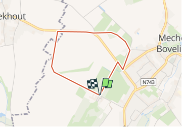
![](/images/other/stat-length.png)
![Trail Walking Heers - Le château de Bovelingen et son allée rouge à Heers - Photo](https://media.geolcdn.com/t/1900/400/7cb2b15e-fb97-4cca-9bad-46eea7191277.jpeg&format=pjpeg&maxdim=2)
Le château de Bovelingen et son allée rouge à Heers
Benjamin27
User GUIDE
![Length](/images/other/stat-length.png)
![Max alt](https://static1.geolcdn.com/siteimages/upload/files/1508320355ic_sort_altitude_max_24dp.png)
![Uphill gradient](https://static1.geolcdn.com/siteimages/upload/files/1508320355ic_sort_den_pos_24dp.png)
![Km-Effort](/images/other/stat-length.png)
![Min alt](https://static1.geolcdn.com/siteimages/upload/files/1508320355ic_sort_altitude_min_24dp.png)
![Downhill gradient](https://static1.geolcdn.com/siteimages/upload/files/1508320355ic_sort_den_neg_24dp.png)
![Boucle](https://static1.geolcdn.com/siteimages/upload/files/16400158638029165_repeat_loop_refresh_sync_direction_icon.png)
![Walking](https://static1.geolcdn.com/sitytour/trail-icons/101.png)
44m
Difficulty : Easy
![Scan this QR Code to open this trail in the SityTrail application](https://capi.geolives.com/qq0zvz2zws4bq2lad0pu/sitytour/trails/3350268/qr.png?size=200)
FREE GPS app for hiking
About
Trail Walking of 2.9 km to be discovered at Flanders, Limburg, Heers. This trail is proposed by Benjamin27.
Description
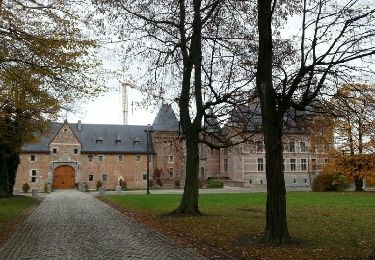
Paysages hesbignons typiques. Promenade agréable entre château, vergers, champs et bois.
👣 Distance : 3km - balisage flèche jaune.
📍 Départ : se garer dans Altenastraat à 3870 Heers au croisement avec « rode dreef ».
🚂🚍 Aller à la gare de Waremme, prendre le bus DE LIJN 37 jusqu’à l’arrêt « Mechelen-Bovelingen Steegske » et marcher 15 minutes jusqu’au départ.
Positioning
Comments
Trails nearby
![Trail Walking Sint-Truiden - Aalst Dorp - Photo](https://media.geolcdn.com/t/375/260/ext.jpg?maxdim=2&url=https%3A%2F%2Fservices.sitytrail.com%2FGeolivesWS%2FDownloadMedia.ashx%3FTrailID%3D238221%26Media%3Dfix__20131125132034.jpg)
![Walking Walking](https://static1.geolcdn.com/sitytour/trail-icons/101.png)
Walking
![](/images/other/stat-length.png)
![](https://static1.geolcdn.com/siteimages/upload/files/16400158638029165_repeat_loop_refresh_sync_direction_icon.png)
![Trail Walking Waremme - Cirkwi-Waremme_-_Autour_de_la_Vallée_du_Geer_-_7,1km - Photo](https://media.geolcdn.com/t/375/260/ext.jpg?maxdim=2&url=https%3A%2F%2Fstatic1.geolcdn.com%2Fsiteimages%2Fupload%2Ffiles%2F1553511878bg_sport_marche.png)
![Walking Walking](https://static1.geolcdn.com/sitytour/trail-icons/101.png)
Walking
![](/images/other/stat-length.png)
![](https://static1.geolcdn.com/siteimages/upload/files/16400158638029165_repeat_loop_refresh_sync_direction_icon.png)
![Trail On foot Sint-Truiden - Cicindria Kerkom blauwe ruit - Photo](https://media.geolcdn.com/t/375/260/06861b0c-4bb0-4416-ae39-787d2bf09bca.jpeg&format=jpg&maxdim=2)
![On foot On foot](https://static1.geolcdn.com/sitytour/trail-icons/100.png)
On foot
![](/images/other/stat-length.png)
![](https://static1.geolcdn.com/siteimages/upload/files/16400158638029165_repeat_loop_refresh_sync_direction_icon.png)
![Trail On foot Heers - Hornbos Groen - Photo](https://media.geolcdn.com/t/375/260/504e6508-a890-4ba4-87e9-eb16d6acfb97.jpeg&format=jpg&maxdim=2)
![On foot On foot](https://static1.geolcdn.com/sitytour/trail-icons/100.png)
![Trail On foot Sint-Truiden - Groot-Gelmen oranje bol - Photo](https://media.geolcdn.com/t/375/260/e3c1a60f-45b7-489f-b886-f877e1eeeb3d.jpeg&format=jpg&maxdim=2)
![On foot On foot](https://static1.geolcdn.com/sitytour/trail-icons/100.png)
On foot
![](/images/other/stat-length.png)
![](https://static1.geolcdn.com/siteimages/upload/files/16400158638029165_repeat_loop_refresh_sync_direction_icon.png)
![Trail On foot Sint-Truiden - Gelinden rode driehoek - Photo](https://media.geolcdn.com/t/375/260/dc0c05ae-7bd4-4447-94f8-784a4fb67064.jpeg&format=jpg&maxdim=2)
![On foot On foot](https://static1.geolcdn.com/sitytour/trail-icons/100.png)
On foot
![](/images/other/stat-length.png)
![](https://static1.geolcdn.com/siteimages/upload/files/16400158638029165_repeat_loop_refresh_sync_direction_icon.png)
![Trail On foot Heers - Mettekoven Oranje bol - Photo](https://media.geolcdn.com/t/375/260/90108129-83cc-42c0-874e-26bc3dd1e893.jpeg&format=jpg&maxdim=2)
![On foot On foot](https://static1.geolcdn.com/sitytour/trail-icons/100.png)
On foot
![](/images/other/stat-length.png)
![](https://static1.geolcdn.com/siteimages/upload/files/16400158638029165_repeat_loop_refresh_sync_direction_icon.png)
![Trail On foot Heers - Mettekoven Rode driehoek - Photo](https://media.geolcdn.com/t/375/260/396414c0-a30e-4c91-a80e-8e7581686d25.jpeg&format=jpg&maxdim=2)
![On foot On foot](https://static1.geolcdn.com/sitytour/trail-icons/100.png)
On foot
![](/images/other/stat-length.png)
![](https://static1.geolcdn.com/siteimages/upload/files/16400158638029165_repeat_loop_refresh_sync_direction_icon.png)
![Trail Walking Heers - Klein-Gelmen - Photo](https://media.geolcdn.com/t/375/260/b974d725-307d-4727-9f84-41626858fa2c.jpg&format=jpg&maxdim=2)
![Walking Walking](https://static1.geolcdn.com/sitytour/trail-icons/101.png)
Walking
![](/images/other/stat-length.png)
![](https://static1.geolcdn.com/siteimages/upload/files/16400158638029165_repeat_loop_refresh_sync_direction_icon.png)