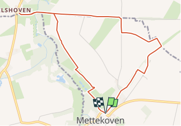
![](/images/other/stat-length.png)
![Trail Walking Heers - Greenspot Mettekoven - grand cru landschap (oranje) - Photo](https://media.geolcdn.com/t/1900/400/7a3cc83e-447b-4472-9c88-dc4f0122645b.jpeg&format=pjpeg&maxdim=2)
Greenspot Mettekoven - grand cru landschap (oranje)
Benjamin27
User GUIDE
![Length](/images/other/stat-length.png)
![Max alt](https://static1.geolcdn.com/siteimages/upload/files/1508320355ic_sort_altitude_max_24dp.png)
![Uphill gradient](https://static1.geolcdn.com/siteimages/upload/files/1508320355ic_sort_den_pos_24dp.png)
![Km-Effort](/images/other/stat-length.png)
![Min alt](https://static1.geolcdn.com/siteimages/upload/files/1508320355ic_sort_altitude_min_24dp.png)
![Downhill gradient](https://static1.geolcdn.com/siteimages/upload/files/1508320355ic_sort_den_neg_24dp.png)
![Boucle](https://static1.geolcdn.com/siteimages/upload/files/16400158638029165_repeat_loop_refresh_sync_direction_icon.png)
![Walking](https://static1.geolcdn.com/sitytour/trail-icons/101.png)
1h21
Difficulty : Easy
![Scan this QR Code to open this trail in the SityTrail application](https://capi.geolives.com/qq0zvz2zws4bq2lad0pu/sitytour/trails/3350267/qr.png?size=200)
FREE GPS app for hiking
About
Trail Walking of 5.1 km to be discovered at Flanders, Limburg, Heers. This trail is proposed by Benjamin27.
Description
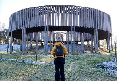
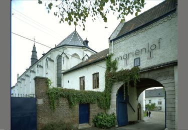
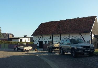
Promenade bucolique entre vergers et patrimoine religieux. Magnifique.
👣 Distance : 4km ( 2km) - balisage rond orange.
📍 Départ : place du village à Mettekoven (mettre Mettekovenstraat à Heers dans le GPS et suivre la rue jusqu’au centre du village).
🚂🚍 Aller à la gare de Tongres, prendre le bus DE LIJN 23A jusqu’à l’arrêt « Hoepertingen - Kruispunt » et marcher 25 minutes jusqu’à la chapelle de Helshoven (elle fait partie de l’itinéraire supplémentaire marqué d’une croix brune).
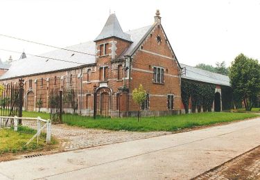
Positioning
Comments
Trails nearby
![Trail Walking Borgloon - Promenade vers l'Aeneas Wilder - Photo](https://media.geolcdn.com/t/375/260/8625d454-03fc-46d2-bafa-261470717766.jpg&format=jpg&maxdim=2)
![Walking Walking](https://static1.geolcdn.com/sitytour/trail-icons/101.png)
Walking
![](/images/other/stat-length.png)
![](https://static1.geolcdn.com/siteimages/upload/files/16400158638029165_repeat_loop_refresh_sync_direction_icon.png)
![Trail Walking Borgloon - randonnee de l eglise fantôme (doorkijkkerkje) - Photo](https://media.geolcdn.com/t/375/260/35833fe8-8dcf-4404-b0af-d88e0896892e.jpg&format=jpg&maxdim=2)
![Walking Walking](https://static1.geolcdn.com/sitytour/trail-icons/101.png)
Walking
![](/images/other/stat-length.png)
![](https://static1.geolcdn.com/siteimages/upload/files/16400158638029165_repeat_loop_refresh_sync_direction_icon.png)
![Trail On foot Borgloon - Mariënlof Rode pijl - Photo](https://media.geolcdn.com/t/375/260/f9353f39-8b13-4a24-b09a-7fe4cf454715.jpeg&format=jpg&maxdim=2)
![On foot On foot](https://static1.geolcdn.com/sitytour/trail-icons/100.png)
On foot
![](/images/other/stat-length.png)
![](https://static1.geolcdn.com/siteimages/upload/files/16400158638029165_repeat_loop_refresh_sync_direction_icon.png)
![Trail On foot Borgloon - Perenboomgaardwandeling - Photo](https://media.geolcdn.com/t/375/260/83d08ccc-3d46-4f67-87f8-eb2b08e4c23b.jpeg&format=jpg&maxdim=2)
![On foot On foot](https://static1.geolcdn.com/sitytour/trail-icons/100.png)
On foot
![](/images/other/stat-length.png)
![](https://static1.geolcdn.com/siteimages/upload/files/16400158638029165_repeat_loop_refresh_sync_direction_icon.png)
![Trail On foot Heers - Hornbos Groen - Photo](https://media.geolcdn.com/t/375/260/504e6508-a890-4ba4-87e9-eb16d6acfb97.jpeg&format=jpg&maxdim=2)
![On foot On foot](https://static1.geolcdn.com/sitytour/trail-icons/100.png)
![Trail On foot Sint-Truiden - Groot-Gelmen oranje bol - Photo](https://media.geolcdn.com/t/375/260/e3c1a60f-45b7-489f-b886-f877e1eeeb3d.jpeg&format=jpg&maxdim=2)
![On foot On foot](https://static1.geolcdn.com/sitytour/trail-icons/100.png)
On foot
![](/images/other/stat-length.png)
![](https://static1.geolcdn.com/siteimages/upload/files/16400158638029165_repeat_loop_refresh_sync_direction_icon.png)
![Trail On foot Sint-Truiden - Gelinden rode driehoek - Photo](https://media.geolcdn.com/t/375/260/dc0c05ae-7bd4-4447-94f8-784a4fb67064.jpeg&format=jpg&maxdim=2)
![On foot On foot](https://static1.geolcdn.com/sitytour/trail-icons/100.png)
On foot
![](/images/other/stat-length.png)
![](https://static1.geolcdn.com/siteimages/upload/files/16400158638029165_repeat_loop_refresh_sync_direction_icon.png)
![Trail On foot Heers - Mettekoven Oranje bol - Photo](https://media.geolcdn.com/t/375/260/90108129-83cc-42c0-874e-26bc3dd1e893.jpeg&format=jpg&maxdim=2)
![On foot On foot](https://static1.geolcdn.com/sitytour/trail-icons/100.png)
On foot
![](/images/other/stat-length.png)
![](https://static1.geolcdn.com/siteimages/upload/files/16400158638029165_repeat_loop_refresh_sync_direction_icon.png)
![Trail On foot Heers - Mettekoven Rode driehoek - Photo](https://media.geolcdn.com/t/375/260/396414c0-a30e-4c91-a80e-8e7581686d25.jpeg&format=jpg&maxdim=2)
![On foot On foot](https://static1.geolcdn.com/sitytour/trail-icons/100.png)
On foot
![](/images/other/stat-length.png)
![](https://static1.geolcdn.com/siteimages/upload/files/16400158638029165_repeat_loop_refresh_sync_direction_icon.png)