Trail Walking Condat-sur-Vézère - Boucle de Maurival à Condat - Photo

Boucle de Maurival à Condat

 pidjam
pidjam

User

© OpenStreetMap contributors
Length
Length
12.3 km
Max alt
Max alt
237 m
Uphill gradient
Uphill gradient
258 m
Km-Effort
Km-Effort  
15.7 km
Min alt
Min alt
78 m
Downhill gradient
Downhill gradient
258 m
Boucle
Boucle
Yes
Creation date :
2022-08-09 08:07:15.495
Updated on :
2022-08-09 08:08:44.504

(0 Reviews)

Walking
Walking
3h34
Difficulty : Difficult

Scan this QR Code to open this trail in the SityTrail application

FREE GPS app for hiking

Logo SityTrail SityTrail

IGN / Geographical institutes

Download SityTrail from the App Store Download SityTrail from Google Play

Logo SityTrail SityTrail World

The world is yours!

Download SityTrail from the App Store Download SityTrail from Google Play Download SityTrail on Huawei AppGallery

About

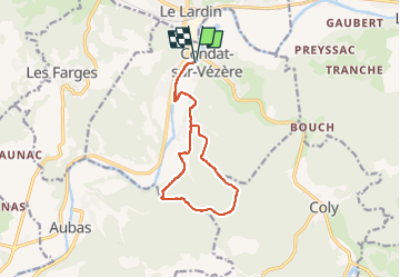
Trail Walking of 12.3 km to be discovered at New Aquitaine, Dordogne, Condat-sur-Vézère. This trail is proposed by pidjam.

Description

Randonnée de 11 km avec de très belles côtes, vous passerez à proximité du château de la Fleunie et visiter le bourg de Condat avec le donjon de l'ancien Château de la Commanderie du XVe siècle

Elevation profile

Points of interest

Point of interest Condat-sur-Vézère - Départ - Photo
pidjam
CONDAT-SUR-VÉZÈRE 
Point of interest Montignac-Lascaux - Suivre boucle de Maurival - Photo
pidjam
MONTIGNAC-LASCAUX 
Point of interest Montignac-Lascaux - au croisement - Photo
pidjam
MONTIGNAC-LASCAUX 
Point of interest Eygurande-et-Gardedeuil - Château de la Fleunie - Photo
pidjam
EYGURANDE-ET-GARDEDEUIL 
Point of interest Montignac-Lascaux - La côte - Photo
pidjam
MONTIGNAC-LASCAUX 
Point of interest Montignac-Lascaux - Retour - Photo
pidjam
MONTIGNAC-LASCAUX 
Point of interest Montignac-Lascaux - Arrivée - Photo
pidjam
MONTIGNAC-LASCAUX 

Positioning

Country:
France
Region :
New Aquitaine
Department/Province :
Dordogne
Municipality :
Condat-sur-Vézère
Location:
Unknown
Start:(UTM)
360713 ; 4997515 (31T) N.

Trails nearby

Trail On foot Condat-sur-Vézère - Boucle de la Commanderie - Photo
On foot
dmortier

On foot

Easy
Condat-sur-Vézère, New Aquitaine, Dordogne, France
9.5 km | 12.6 km-effort
2h 20min
Yes
Trail Walking Les Farges - vezere_6 - Photo
Walking
fanthou

Walking

Medium
(1)
Les Farges, New Aquitaine, Dordogne, France
8.7 km | 11.8 km-effort
2h 31min
Yes
Trail Walking Les Farges - vezere_5 - Photo
Walking
fanthou

Walking

Medium
(2)
Les Farges, New Aquitaine, Dordogne, France
7 km | 9.6 km-effort
2h 3min
Yes
Trail Walking Peyrignac - boucle de la nuelle  - Photo
Walking
dmortier

Walking

Medium
Peyrignac, New Aquitaine, Dordogne, France
6.9 km | 9.3 km-effort
2h 14min
Yes
Trail Walking Coly-Saint-Amand - coly300322 - Photo
Walking
Reider

Walking

Difficult
Coly-Saint-Amand, New Aquitaine, Dordogne, France
11.4 km | 14.5 km-effort
3h 22min
Yes
Trail Walking Aubas - Circuit des trois châteaux - Photo
Walking
CC.RIDER

Walking

Difficult
(2)
Aubas, New Aquitaine, Dordogne, France
13.7 km | 18.1 km-effort
4h 7min
Yes
Trail Walking Terrasson-Lavilledieu - balade a preyssac - Photo
Walking
jouetpas

Walking

Easy
Terrasson-Lavilledieu, New Aquitaine, Dordogne, France
4.1 km | 5.9 km-effort
1h 23min
Yes
Trail Walking Beauregard-de-Terrasson - track - Photo
Walking
swp648

Walking

Difficult
Beauregard-de-Terrasson, New Aquitaine, Dordogne, France
11.4 km | 15.7 km-effort
3h 34min
Yes
Trail Walking Les Farges - 2024-01-31 13:41 - Photo
Walking
Reider

Walking

Difficult
Les Farges, New Aquitaine, Dordogne, France
10.9 km | 15.1 km-effort
3h 26min
Yes


Close
My subscriptions