![](/images/other/stat-length.png)
![Trail Walking Libin - Smuid - Bois de Remimont (SH25) - Photo](https://media.geolcdn.com/t/1900/400/ext.pjpeg?maxdim=2&url=https%3A%2F%2Fservices.sitytrail.com%2FGeolivesWS%2FDownloadMedia.ashx%3FTrailID%3D334544%26Media%3D35b85ba6-f68e-408e-8f81-a4091c77b222.jpg)
Smuid - Bois de Remimont (SH25)
La Grande Forêt de Saint-Hubert
Randonnées de la Grande Forêt de Saint-Hubert GUIDE+
![Length](/images/other/stat-length.png)
![Max alt](https://static1.geolcdn.com/siteimages/upload/files/1508320355ic_sort_altitude_max_24dp.png)
![Uphill gradient](https://static1.geolcdn.com/siteimages/upload/files/1508320355ic_sort_den_pos_24dp.png)
![Km-Effort](/images/other/stat-length.png)
![Min alt](https://static1.geolcdn.com/siteimages/upload/files/1508320355ic_sort_altitude_min_24dp.png)
![Downhill gradient](https://static1.geolcdn.com/siteimages/upload/files/1508320355ic_sort_den_neg_24dp.png)
![Boucle](https://static1.geolcdn.com/siteimages/upload/files/16400158638029165_repeat_loop_refresh_sync_direction_icon.png)
![Signpost](https://services.sitytrail.com/GeolivesWS/DownloadMedia.ashx?TrailID=334544&Media=balise.png)
![Walking](https://static1.geolcdn.com/sitytour/trail-icons/101.png)
2h50
Difficulty : Difficult
![Scan this QR Code to open this trail in the SityTrail application](https://capi.geolives.com/qq0zvz2zws4bq2lad0pu/sitytour/trails/334544/qr.png?size=200)
FREE GPS app for hiking
About
Trail Walking of 10.2 km to be discovered at Wallonia, Luxembourg, Libin. This trail is proposed by La Grande Forêt de Saint-Hubert.
Description
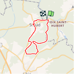
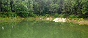
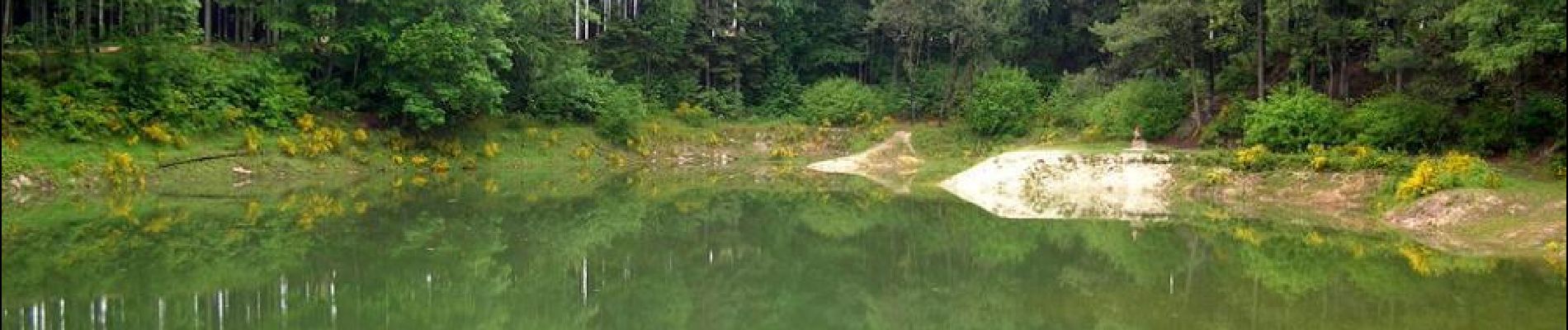
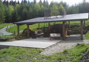
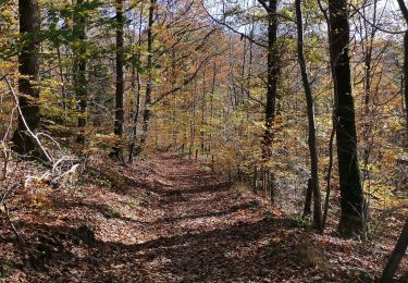
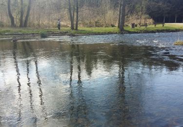
Balade essentiellement en forêt (de toutes essences), quelques prairies aux alentours du village de Smuid. La ballade débute le long de la Lhomme, puis suit une petite vallée et un petit ruisseau jusqu’au village de Smuid. Village perché avec vue vers les massifs de St-Hubert. Architecture assez homogène (maisons en pierres du pays pour la plupart). Suite de la promenade en partie sur une route en béton avant d’arriver au site dit « du kaolin » (aire de pique-nique). La ballade se poursuit en alternant bordure de forêt et bois de feuillus. Vue assez dégagée vers Libin et les forêts à l’arrière. Puis continue pour rejoindre l’ancienne assiette du tramway vicinal et une petite vallée comportant quelques étangs, en fin de promenade, et des vestiges d’abissage. Montées et vallonné dans la première moitié du parcours, puis plat et en descente sur l’autre moitié.
Extrait de la carte de promenade « Au Pays de Saint-Hubert » (30 balades pédestres, 6 circuits VTT – carte topographique 1/25.000) disponible au Royal Syndicat d’Initiative de Saint-Hubert au prix de 8€.
Royal Syndicat d’Initiative de Saint-Hubert
Place du Marché, n°15
B-6870 SAINT-HUBERT
Tél.: 32 (0)61 61 30 10
Fax: 32 (0)61 61 54 44
rsi@saint-hubert-tourisme.be
www.rsi-sainthubert.be
facebook.com/rsisainthubert
Positioning
Comments
Trails nearby
![Trail Walking Saint-Hubert - Hatrival - Banalbois (SH13) - Photo](https://media.geolcdn.com/t/375/260/ext.jpg?maxdim=2&url=https%3A%2F%2Fservices.sitytrail.com%2FGeolivesWS%2FDownloadMedia.ashx%3FTrailID%3D334467%26Media%3D16828998-416a-43a0-960f-95ce479e5d6d.jpg)
![Walking Walking](https://static1.geolcdn.com/sitytour/trail-icons/101.png)
Walking
![](/images/other/stat-length.png)
![](https://static1.geolcdn.com/siteimages/upload/files/16400158638029165_repeat_loop_refresh_sync_direction_icon.png)
![Trail Walking Saint-Hubert - Poix - Sainte-Adeline (SH15) - Photo](https://media.geolcdn.com/t/375/260/ext.jpg?maxdim=2&url=https%3A%2F%2Fservices.sitytrail.com%2FGeolivesWS%2FDownloadMedia.ashx%3FTrailID%3D334489%26Media%3Dff5c6d1c-0697-4565-9157-6580a8b8d275.jpg)
![Walking Walking](https://static1.geolcdn.com/sitytour/trail-icons/101.png)
Walking
![](/images/other/stat-length.png)
![](https://static1.geolcdn.com/siteimages/upload/files/16400158638029165_repeat_loop_refresh_sync_direction_icon.png)
![Trail Walking Saint-Hubert - Mirwart_Vieux Moulin de Mirwart_Alternative Forêt (SH29 bis) - Photo](https://media.geolcdn.com/t/375/260/ext.jpg?maxdim=2&url=https%3A%2F%2Fservices.sitytrail.com%2FGeolivesWS%2FDownloadMedia.ashx%3FTrailID%3D366988%26Media%3D029a75cb-b10f-4900-87ea-e92327ef26cb.jpg)
![Walking Walking](https://static1.geolcdn.com/sitytour/trail-icons/101.png)
Walking
![](/images/other/stat-length.png)
![](https://static1.geolcdn.com/siteimages/upload/files/16400158638029165_repeat_loop_refresh_sync_direction_icon.png)
![Trail Walking Saint-Hubert - Marche ADEPS Arville - Photo](https://media.geolcdn.com/t/375/260/3bbd3001-2495-4fe0-a9c1-b38774f0038e.jpg&format=jpg&maxdim=2)
![Walking Walking](https://static1.geolcdn.com/sitytour/trail-icons/101.png)
Walking
![](/images/other/stat-length.png)
![](https://static1.geolcdn.com/siteimages/upload/files/16400158638029165_repeat_loop_refresh_sync_direction_icon.png)
![Trail Mountain bike Saint-Hubert - Poix - La Lhomme (VTT SH06) - Photo](https://media.geolcdn.com/t/375/260/ext.jpg?maxdim=2&url=https%3A%2F%2Fservices.sitytrail.com%2FGeolivesWS%2FDownloadMedia.ashx%3FTrailID%3D334556%26Media%3Da91ea124-054e-449d-9773-8d26e176c2fd.jpg)
![Mountain bike Mountain bike](https://static1.geolcdn.com/sitytour/trail-icons/202.png)
Mountain bike
![](/images/other/stat-length.png)
![](https://static1.geolcdn.com/siteimages/upload/files/16400158638029165_repeat_loop_refresh_sync_direction_icon.png)
![Trail Walking Saint-Hubert - Mirwart - Marsoult (SH26) - Photo](https://media.geolcdn.com/t/375/260/ext.jpg?maxdim=2&url=https%3A%2F%2Fservices.sitytrail.com%2FGeolivesWS%2FDownloadMedia.ashx%3FTrailID%3D334545%26Media%3Dd3afe587-762b-4377-a558-ad97422cc718.jpg)
![Walking Walking](https://static1.geolcdn.com/sitytour/trail-icons/101.png)
Walking
![](/images/other/stat-length.png)
![](https://static1.geolcdn.com/siteimages/upload/files/16400158638029165_repeat_loop_refresh_sync_direction_icon.png)
![Trail Walking Saint-Hubert - MIRWART ... mon beau miroir ! - Photo](https://media.geolcdn.com/t/375/260/974e6b0d-ea78-42f7-a2f2-25d51f2ec292.jpg&format=jpg&maxdim=2)
![Walking Walking](https://static1.geolcdn.com/sitytour/trail-icons/101.png)
Walking
![](/images/other/stat-length.png)
![](https://static1.geolcdn.com/siteimages/upload/files/16400158638029165_repeat_loop_refresh_sync_direction_icon.png)
![Trail Walking Saint-Hubert - mirwart - Photo](https://media.geolcdn.com/t/375/260/d4149497-6b7e-4d45-9b55-5ef5932495b2.jpg&format=jpg&maxdim=2)
![Walking Walking](https://static1.geolcdn.com/sitytour/trail-icons/101.png)
Walking
![](/images/other/stat-length.png)
![](https://static1.geolcdn.com/siteimages/upload/files/16400158638029165_repeat_loop_refresh_sync_direction_icon.png)
![Trail Walking Saint-Hubert - Mirwart 13 Km D+ 334m - Photo](https://media.geolcdn.com/t/375/260/49259492-df75-45f3-99f3-50da532cb38e.jpg&format=jpg&maxdim=2)
![Walking Walking](https://static1.geolcdn.com/sitytour/trail-icons/101.png)
Walking
![](/images/other/stat-length.png)
![](https://static1.geolcdn.com/siteimages/upload/files/16400158638029165_repeat_loop_refresh_sync_direction_icon.png)
tres Belle balade principalement du bois et le calme absolu
triste balade car l'on passe par des vallées qui manquent de points de vue
mooie wandeling. bewegwijzering soms zeer slecht aangegeven
Leuke app!