![](/images/other/stat-length.png)
![Trail Walking Sainte-Ode - Lavacherie - Promenade de la Forêt de Freyr (L4) - Photo](https://media.geolcdn.com/t/1900/400/ext.pjpeg?maxdim=2&url=https%3A%2F%2Fstatic1.geolcdn.com%2Fsiteimages%2Fupload%2Ffiles%2F1553511878bg_sport_marche.png)
Lavacherie - Promenade de la Forêt de Freyr (L4)
La Grande Forêt de Saint-Hubert
Randonnées de la Grande Forêt de Saint-Hubert GUIDE+
![Length](/images/other/stat-length.png)
Length
9.3 km
![Max alt](https://static1.geolcdn.com/siteimages/upload/files/1508320355ic_sort_altitude_max_24dp.png)
Max alt
594 m
![Uphill gradient](https://static1.geolcdn.com/siteimages/upload/files/1508320355ic_sort_den_pos_24dp.png)
Uphill gradient
240 m
![Km-Effort](/images/other/stat-length.png)
Km-Effort
12.5 km
![Min alt](https://static1.geolcdn.com/siteimages/upload/files/1508320355ic_sort_altitude_min_24dp.png)
Min alt
408 m
![Downhill gradient](https://static1.geolcdn.com/siteimages/upload/files/1508320355ic_sort_den_neg_24dp.png)
Downhill gradient
241 m
![Boucle](https://static1.geolcdn.com/siteimages/upload/files/16400158638029165_repeat_loop_refresh_sync_direction_icon.png)
Boucle
Yes
Creation date :
2017-09-26 00:00:00.0
Updated on :
2017-09-26 00:00:00.0
![Walking](https://static1.geolcdn.com/sitytour/trail-icons/101.png)
2h38
Difficulty : Medium
![Scan this QR Code to open this trail in the SityTrail application](https://capi.geolives.com/qq0zvz2zws4bq2lad0pu/sitytour/trails/334512/qr.png?size=200)
FREE GPS app for hiking
About
Trail Walking of 9.3 km to be discovered at Wallonia, Luxembourg, Sainte-Ode. This trail is proposed by La Grande Forêt de Saint-Hubert.
Description
Itinéraire repris sur la carte IGN des promenades de Sainte-Ode (1:25 000) vendue à 8,00 €.
Concepteur: Syndicat d'Initiative de Sainte-Ode.
Positioning
Country:
Belgium
Region :
Wallonia
Department/Province :
Luxembourg
Municipality :
Sainte-Ode
Location:
Lavacherie
Start:(Dec)
Start:(UTM)
679265 ; 5547460 (31U) N.
Comments
Trails nearby
![Trail Walking Tenneville - Laneuville au Bois - Promenade de la Basseille (09) - Photo](https://media.geolcdn.com/t/375/260/ext.jpg?maxdim=2&url=https%3A%2F%2Fservices.sitytrail.com%2FGeolivesWS%2FDownloadMedia.ashx%3FTrailID%3D334566%26Media%3D72c736cf-9f9a-448b-b76f-dc024acf7652.jpg)
![Walking Walking](https://static1.geolcdn.com/sitytour/trail-icons/101.png)
Laneuville au Bois - Promenade de la Basseille (09)
Walking
Difficult
(7)
Tenneville,
Wallonia,
Luxembourg,
Belgium
![](/images/other/stat-length.png)
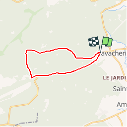
12.3 km | 15.8 km-effort
3h 22min
![](https://static1.geolcdn.com/siteimages/upload/files/16400158638029165_repeat_loop_refresh_sync_direction_icon.png)
Yes
![Trail Walking Sainte-Ode - RB-LUX-08 - Raccourci - De part et d’autre de l’Ourthe occidentale - Photo](https://media.geolcdn.com/t/375/260/ext.jpg?maxdim=2&url=https%3A%2F%2Fservices.sitytrail.com%2FGeolivesWS%2FDownloadMedia.ashx%3FTrailID%3D216067%26Media%3Da5159bed-d44e-45f6-91bf-98d2633ab672.jpg)
![Walking Walking](https://static1.geolcdn.com/sitytour/trail-icons/101.png)
RB-LUX-08 - Raccourci - De part et d’autre de l’Ourthe occidentale
Walking
Difficult
(2)
Sainte-Ode,
Wallonia,
Luxembourg,
Belgium
![](/images/other/stat-length.png)
15.2 km | 18.6 km-effort
4h 13min
![](https://static1.geolcdn.com/siteimages/upload/files/16400158638029165_repeat_loop_refresh_sync_direction_icon.png)
Yes
![Trail Walking Sainte-Ode - Tonny - Promenade de Tonny (A6) - Photo](https://media.geolcdn.com/t/375/260/ext.jpg?maxdim=2&url=https%3A%2F%2Fservices.sitytrail.com%2FGeolivesWS%2FDownloadMedia.ashx%3FTrailID%3D470390%26Media%3D36d9826a-10d7-493f-bb50-7affdbc9817f.jpg)
![Walking Walking](https://static1.geolcdn.com/sitytour/trail-icons/101.png)
Tonny - Promenade de Tonny (A6)
Walking
Medium
(3)
Sainte-Ode,
Wallonia,
Luxembourg,
Belgium
![](/images/other/stat-length.png)
9.5 km | 12.2 km-effort
2h 36min
![](https://static1.geolcdn.com/siteimages/upload/files/16400158638029165_repeat_loop_refresh_sync_direction_icon.png)
Yes
![Trail Walking Sainte-Ode - Lavacherie - Promenade de la Bonne Dame (L1) - Photo](https://media.geolcdn.com/t/375/260/ext.jpg?maxdim=2&url=https%3A%2F%2Fservices.sitytrail.com%2FGeolivesWS%2FDownloadMedia.ashx%3FTrailID%3D334508%26Media%3Dbeafdf5d-7e56-47ba-baef-9d2f39d35ed9.png)
![Walking Walking](https://static1.geolcdn.com/sitytour/trail-icons/101.png)
Lavacherie - Promenade de la Bonne Dame (L1)
Walking
Medium
(5)
Sainte-Ode,
Wallonia,
Luxembourg,
Belgium
![](/images/other/stat-length.png)
7.7 km | 10 km-effort
2h 10min
![](https://static1.geolcdn.com/siteimages/upload/files/16400158638029165_repeat_loop_refresh_sync_direction_icon.png)
Yes
![Trail Walking Sainte-Ode - Amberloup, Natura 2000 - Des sites qui valent le détour. Lx11 - Photo](https://media.geolcdn.com/t/375/260/ext.jpg?maxdim=2&url=https%3A%2F%2Fservices.sitytrail.com%2FGeolivesWS%2FDownloadMedia.ashx%3FTrailID%3D181909%26Media%3Dd96a433d-6654-4704-ae71-038ac1db039e.JPG)
![Walking Walking](https://static1.geolcdn.com/sitytour/trail-icons/101.png)
Amberloup, Natura 2000 - Des sites qui valent le détour. Lx11
Walking
Easy
(4)
Sainte-Ode,
Wallonia,
Luxembourg,
Belgium
![](/images/other/stat-length.png)
4.2 km | 5 km-effort
1h 6min
![](https://static1.geolcdn.com/siteimages/upload/files/16400158638029165_repeat_loop_refresh_sync_direction_icon.png)
Yes
![Trail Walking Sainte-Ode - RB-LUX-08 - De part et d’autre de l’Ourthe occidentale - Photo](https://media.geolcdn.com/t/375/260/ext.jpg?maxdim=2&url=https%3A%2F%2Fservices.sitytrail.com%2FGeolivesWS%2FDownloadMedia.ashx%3FTrailID%3D179624%26Media%3D32148395-8c8d-48d3-9d07-5af495614365.jpg)
![Walking Walking](https://static1.geolcdn.com/sitytour/trail-icons/101.png)
RB-LUX-08 - De part et d’autre de l’Ourthe occidentale
Walking
Medium
(1)
Sainte-Ode,
Wallonia,
Luxembourg,
Belgium
![](/images/other/stat-length.png)
23 km | 29 km-effort
6h 14min
![](https://static1.geolcdn.com/siteimages/upload/files/16400158638029165_repeat_loop_refresh_sync_direction_icon.png)
Yes
![Trail Walking Sainte-Ode - rando lavacherie 5-02-2022 - Photo](https://media.geolcdn.com/t/375/260/51d83bb4-0870-46ee-b60b-b2146d049ac2.jpg&format=jpg&maxdim=2)
![Walking Walking](https://static1.geolcdn.com/sitytour/trail-icons/101.png)
rando lavacherie 5-02-2022
Walking
Medium
(1)
Sainte-Ode,
Wallonia,
Luxembourg,
Belgium
![](/images/other/stat-length.png)
8.6 km | 12.1 km-effort
2h 17min
![](https://static1.geolcdn.com/siteimages/upload/files/16400158638029165_repeat_loop_refresh_sync_direction_icon.png)
Yes
![Trail Walking Sainte-Ode - rando lavacherie 29/08/2020 - Photo](https://media.geolcdn.com/t/375/260/748c1b0e-fc3a-4c4c-86ea-3c557994f8d1.jpg&format=jpg&maxdim=2)
![Walking Walking](https://static1.geolcdn.com/sitytour/trail-icons/101.png)
rando lavacherie 29/08/2020
Walking
Medium
(1)
Sainte-Ode,
Wallonia,
Luxembourg,
Belgium
![](/images/other/stat-length.png)
15.3 km | 20 km-effort
3h 15min
![](https://static1.geolcdn.com/siteimages/upload/files/16400158638029165_repeat_loop_refresh_sync_direction_icon.png)
Yes
![Trail On foot Sainte-Ode - Sainte-ode - Photo](https://media.geolcdn.com/t/375/260/176a04b2-22ff-4a89-b268-e407ad0ae248.jpg&format=jpg&maxdim=2)
![On foot On foot](https://static1.geolcdn.com/sitytour/trail-icons/100.png)
Sainte-ode
On foot
Easy
(3)
Sainte-Ode,
Wallonia,
Luxembourg,
Belgium
![](/images/other/stat-length.png)
8.9 km | 11.9 km-effort
Unknown
![](https://static1.geolcdn.com/siteimages/upload/files/16400158638029165_repeat_loop_refresh_sync_direction_icon.png)
Yes