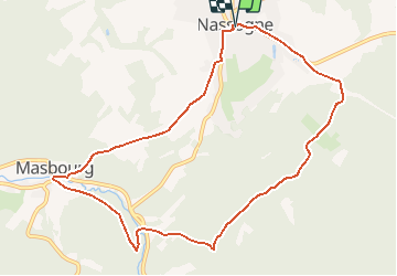
![](/images/other/stat-length.png)
![Trail Walking Nassogne - Nassogne - Promenade de la Masblette (NG 21) - Photo](https://media.geolcdn.com/t/1900/400/ext.pjpeg?maxdim=2&url=https%3A%2F%2Fservices.sitytrail.com%2FGeolivesWS%2FDownloadMedia.ashx%3FTrailID%3D334492%26Media%3D7e3b25c4-69c3-43b8-9aff-2ac9aa518f72.jpg)
Nassogne - Promenade de la Masblette (NG 21)
La Grande Forêt de Saint-Hubert
Randonnées de la Grande Forêt de Saint-Hubert GUIDE+
![Length](/images/other/stat-length.png)
![Max alt](https://static1.geolcdn.com/siteimages/upload/files/1508320355ic_sort_altitude_max_24dp.png)
![Uphill gradient](https://static1.geolcdn.com/siteimages/upload/files/1508320355ic_sort_den_pos_24dp.png)
![Km-Effort](/images/other/stat-length.png)
![Min alt](https://static1.geolcdn.com/siteimages/upload/files/1508320355ic_sort_altitude_min_24dp.png)
![Downhill gradient](https://static1.geolcdn.com/siteimages/upload/files/1508320355ic_sort_den_neg_24dp.png)
![Boucle](https://static1.geolcdn.com/siteimages/upload/files/16400158638029165_repeat_loop_refresh_sync_direction_icon.png)
![Signpost](https://services.sitytrail.com/GeolivesWS/DownloadMedia.ashx?TrailID=334492&Media=balise.png)
![Walking](https://static1.geolcdn.com/sitytour/trail-icons/101.png)
2h42
Difficulty : Medium
![Scan this QR Code to open this trail in the SityTrail application](https://capi.geolives.com/qq0zvz2zws4bq2lad0pu/sitytour/trails/334492/qr.png?size=200)
FREE GPS app for hiking
About
Trail Walking of 9.4 km to be discovered at Wallonia, Luxembourg, Nassogne. This trail is proposed by La Grande Forêt de Saint-Hubert.
Description
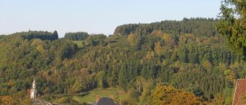
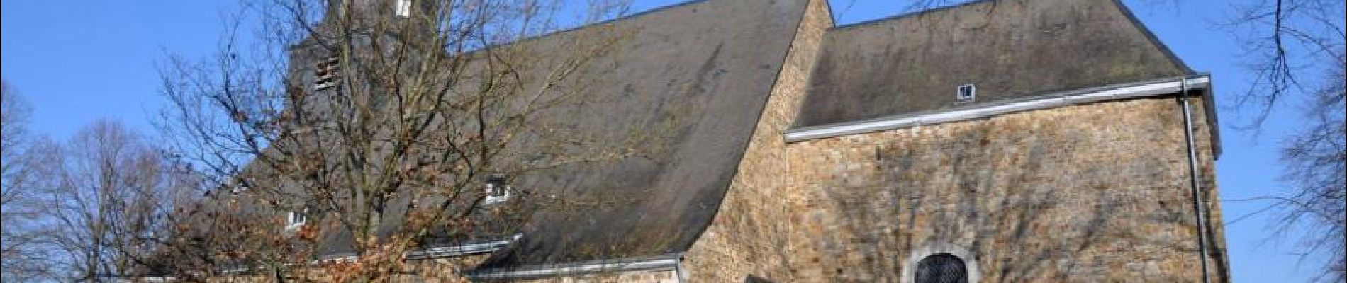
Cette promenade vous emmène dans le village de Masbourg niché dans la vallée de la Masblette. Vous emprunterez un chemin pittoresque qui surplombe la rivière jusqu'au 'Crawi', où vous découvrirez une spacieuse aire de pique-nique et de barbecue. Ensuite, vous suivrez un chemin forestier qui doucement mais sûrement remonte vers Nassogne.
Extrait de la carte des promenades de l'entité de Nassogne (23 promenades balisées - carte topographique 1/25.000 - 7,00 €) disponible à l'Office Communal du Tourisme de l'entité de Nassogne ou à la Maison du Tourisme du Pays de Marche & Nassogne.
Concepteur: Office Communal du Tourisme de l'entité de Nassogne - Rue de Lahaut, 3 - 6950 Nassogne - 32(0)84/22.15.58 - office.tourisme@nassogne.be.
Points of interest
Positioning
Comments
Trails nearby
![Trail Walking Tellin - GG-Lu-13_Grupont - Poix-Saint-Hubert - Photo](https://media.geolcdn.com/t/375/260/5959367f-35e5-42da-bbcc-7bf6a947c3d1.jpg&format=jpg&maxdim=2)
![Walking Walking](https://static1.geolcdn.com/sitytour/trail-icons/101.png)
Walking
![](/images/other/stat-length.png)
![](https://static1.geolcdn.com/siteimages/upload/files/16400158638029165_repeat_loop_refresh_sync_direction_icon.png)
![Trail Walking Tellin - Balade à Grupont - Photo](https://media.geolcdn.com/t/375/260/ext.jpg?maxdim=2&url=https%3A%2F%2Fservices.sitytrail.com%2FGeolivesWS%2FDownloadMedia.ashx%3FTrailID%3D963883%26Media%3D35fabe2c-0877-4435-b4f9-1ab0863175f9.jpg)
![Walking Walking](https://static1.geolcdn.com/sitytour/trail-icons/101.png)
Walking
![](/images/other/stat-length.png)
![](https://static1.geolcdn.com/siteimages/upload/files/16400158638029165_repeat_loop_refresh_sync_direction_icon.png)
![Trail Walking Tellin - Grupont - Promenade du Bois du Machi (EN) - Photo](https://media.geolcdn.com/t/375/260/ext.jpg?maxdim=2&url=https%3A%2F%2Fservices.sitytrail.com%2FGeolivesWS%2FDownloadMedia.ashx%3FTrailID%3D334604%26Media%3Dcf0f2910-0190-4469-9f88-d94c6a2716b3.jpg)
![Walking Walking](https://static1.geolcdn.com/sitytour/trail-icons/101.png)
Walking
![](/images/other/stat-length.png)
![](https://static1.geolcdn.com/siteimages/upload/files/16400158638029165_repeat_loop_refresh_sync_direction_icon.png)
![Trail Mountain bike Nassogne - Nassogne - Circuit VTT rouge 4 - Photo](https://media.geolcdn.com/t/375/260/ext.jpg?maxdim=2&url=https%3A%2F%2Fservices.sitytrail.com%2FGeolivesWS%2FDownloadMedia.ashx%3FTrailID%3D334498%26Media%3D7e3b25c4-69c3-43b8-9aff-2ac9aa518f72.jpg)
![Mountain bike Mountain bike](https://static1.geolcdn.com/sitytour/trail-icons/202.png)
Mountain bike
![](/images/other/stat-length.png)
![](https://static1.geolcdn.com/siteimages/upload/files/16400158638029165_repeat_loop_refresh_sync_direction_icon.png)
![Trail Walking Nassogne - Grune - Promenade du Chevenys (NG 11) - Photo](https://media.geolcdn.com/t/375/260/ext.jpg?maxdim=2&url=https%3A%2F%2Fservices.sitytrail.com%2FGeolivesWS%2FDownloadMedia.ashx%3FTrailID%3D334481%26Media%3Dba9aa845-ef30-419f-8abc-4937a3dcd165.jpg)
![Walking Walking](https://static1.geolcdn.com/sitytour/trail-icons/101.png)
Walking
![](/images/other/stat-length.png)
![](https://static1.geolcdn.com/siteimages/upload/files/16400158638029165_repeat_loop_refresh_sync_direction_icon.png)
![Trail Walking Nassogne - Grune - Promenade des Prés (NG 10) - Photo](https://media.geolcdn.com/t/375/260/ext.jpg?maxdim=2&url=https%3A%2F%2Fservices.sitytrail.com%2FGeolivesWS%2FDownloadMedia.ashx%3FTrailID%3D334480%26Media%3D401003b0-e8fc-4e5d-bd6d-081ce49adfea.jpg)
![Walking Walking](https://static1.geolcdn.com/sitytour/trail-icons/101.png)
Walking
![](/images/other/stat-length.png)
![](https://static1.geolcdn.com/siteimages/upload/files/16400158638029165_repeat_loop_refresh_sync_direction_icon.png)
![Trail Walking Nassogne - Forrières/Lesterny - Promenade Saint-Martin (NG 08) - Photo](https://media.geolcdn.com/t/375/260/ext.jpg?maxdim=2&url=https%3A%2F%2Fservices.sitytrail.com%2FGeolivesWS%2FDownloadMedia.ashx%3FTrailID%3D334477%26Media%3Dba77daec-7d1b-4594-8484-87260d6142b8.jpg)
![Walking Walking](https://static1.geolcdn.com/sitytour/trail-icons/101.png)
Walking
![](/images/other/stat-length.png)
![](https://static1.geolcdn.com/siteimages/upload/files/16400158638029165_repeat_loop_refresh_sync_direction_icon.png)
![Trail Walking Nassogne - Forrières - Promenade de Cocher (NG 07) - Photo](https://media.geolcdn.com/t/375/260/ext.jpg?maxdim=2&url=https%3A%2F%2Fservices.sitytrail.com%2FGeolivesWS%2FDownloadMedia.ashx%3FTrailID%3D334476%26Media%3D562f483c-8c06-4d7b-aecf-2f9a32b3894e.jpg)
![Walking Walking](https://static1.geolcdn.com/sitytour/trail-icons/101.png)
Walking
![](/images/other/stat-length.png)
![](https://static1.geolcdn.com/siteimages/upload/files/16400158638029165_repeat_loop_refresh_sync_direction_icon.png)
![Trail Walking Nassogne - Ambly - Promenade de Javingue (NG 02) - Photo](https://media.geolcdn.com/t/375/260/ext.jpg?maxdim=2&url=https%3A%2F%2Fservices.sitytrail.com%2FGeolivesWS%2FDownloadMedia.ashx%3FTrailID%3D334471%26Media%3Ddbed45a4-783f-4743-9c84-6e8d4ec05336.jpg)
![Walking Walking](https://static1.geolcdn.com/sitytour/trail-icons/101.png)
Walking
![](/images/other/stat-length.png)
![](https://static1.geolcdn.com/siteimages/upload/files/16400158638029165_repeat_loop_refresh_sync_direction_icon.png)
Beau parcours, avec une belle descente assez raide avant d'arriver à Masbourg.
tres beau parcours. très bien indiqué. appli au top avec réalité terrain
très beau parcours