![](/images/other/stat-length.png)
![Trail Hybrid bike L'Épine - L'Épine-Cœur de Noirmoutier - Photo](https://media.geolcdn.com/t/1900/400/ext.pjpeg?maxdim=2&url=https%3A%2F%2Fstatic1.geolcdn.com%2Fsiteimages%2Fupload%2Ffiles%2F1524743154velo.jpg)
L'Épine-Cœur de Noirmoutier
Sigmut
User
![Length](/images/other/stat-length.png)
![Max alt](https://static1.geolcdn.com/siteimages/upload/files/1508320355ic_sort_altitude_max_24dp.png)
![Uphill gradient](https://static1.geolcdn.com/siteimages/upload/files/1508320355ic_sort_den_pos_24dp.png)
![Km-Effort](/images/other/stat-length.png)
![Min alt](https://static1.geolcdn.com/siteimages/upload/files/1508320355ic_sort_altitude_min_24dp.png)
![Downhill gradient](https://static1.geolcdn.com/siteimages/upload/files/1508320355ic_sort_den_neg_24dp.png)
![Boucle](https://static1.geolcdn.com/siteimages/upload/files/16400158638029165_repeat_loop_refresh_sync_direction_icon.png)
![Hybrid bike](https://static1.geolcdn.com/sitytour/trail-icons/203.png)
2h10
Difficulty : Very easy
![Scan this QR Code to open this trail in the SityTrail application](https://capi.geolives.com/qq0zvz2zws4bq2lad0pu/sitytour/trails/3341972/qr.png?size=200)
FREE GPS app for hiking
About
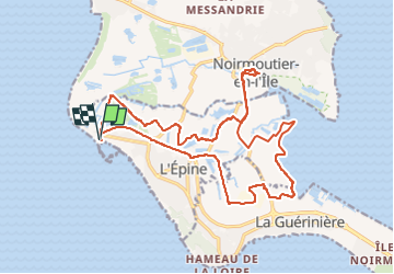
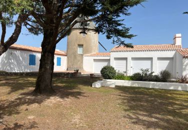
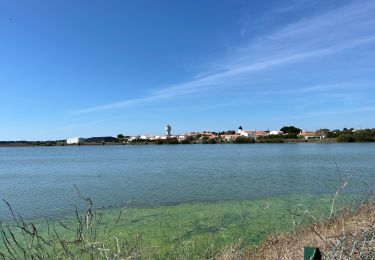
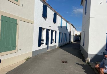
Trail Hybrid bike of 21 km to be discovered at Pays de la Loire, Vendée, L'Épine. This trail is proposed by Sigmut.
Description
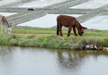
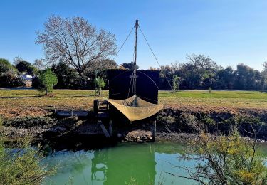
Bonne aperçu de Noirmoutier et des marais salants.
Par contre il y a vraiment trop de voitures et cela rend la pratique du vélo vraiment désagréable notamment le long des routes trop fréquentées. On ne sens plus que les odeurs d'essence et c'est à se demander quel est le niveau de pollution du sel de Noirmoutier. Nous n'en n'avons d'ailleurs pas acheté par précaution. Dommage pour ceux qui travaillent dans ces marais.
Positioning
Comments
Trails nearby
![Trail Walking L'Épine - Les Marais de Luzeronde - Photo](https://media.geolcdn.com/t/375/260/ext.jpg?maxdim=2&url=https%3A%2F%2Fstatic1.geolcdn.com%2Fsiteimages%2Fupload%2Ffiles%2F1553511878bg_sport_marche.png)
![Walking Walking](https://static1.geolcdn.com/sitytour/trail-icons/101.png)
Walking
![](/images/other/stat-length.png)
![](https://static1.geolcdn.com/siteimages/upload/files/16400158638029165_repeat_loop_refresh_sync_direction_icon.png)
![Trail On foot Noirmoutier-en-l'Île - Roses trémières - Photo](https://media.geolcdn.com/t/375/260/504a4f09-026b-4f3b-a144-9641852cfb05.jpeg&format=jpg&maxdim=2)
![On foot On foot](https://static1.geolcdn.com/sitytour/trail-icons/100.png)
On foot
![](/images/other/stat-length.png)
![](https://static1.geolcdn.com/siteimages/upload/files/16400158638029165_repeat_loop_refresh_sync_direction_icon.png)
![Trail On foot La Guérinière - En Passant par les Moulins - Photo](https://media.geolcdn.com/t/375/260/ccc103f2-0cff-4e2a-b30b-b4e364a262b4.jpeg&format=jpg&maxdim=2)
![On foot On foot](https://static1.geolcdn.com/sitytour/trail-icons/100.png)
On foot
![](/images/other/stat-length.png)
![](https://static1.geolcdn.com/siteimages/upload/files/16400158638029165_repeat_loop_refresh_sync_direction_icon.png)
![Trail On foot L'Épine - Chemin de mer et de marais - Photo](https://media.geolcdn.com/t/375/260/ded2016b-df3d-4278-8be0-d3af6896ca41.jpeg&format=jpg&maxdim=2)
![On foot On foot](https://static1.geolcdn.com/sitytour/trail-icons/100.png)
On foot
![](/images/other/stat-length.png)
![](https://static1.geolcdn.com/siteimages/upload/files/16400158638029165_repeat_loop_refresh_sync_direction_icon.png)
![Trail Hybrid bike L'Épine - B02 - Boucle entre plages et ports - Photo](https://media.geolcdn.com/t/375/260/ext.jpg?maxdim=2&url=https%3A%2F%2Fstatic1.geolcdn.com%2Fsiteimages%2Fupload%2Ffiles%2F1524743154velo.jpg)
![Hybrid bike Hybrid bike](https://static1.geolcdn.com/sitytour/trail-icons/203.png)
Hybrid bike
![](/images/other/stat-length.png)
![](https://static1.geolcdn.com/siteimages/upload/files/16400158638029165_repeat_loop_refresh_sync_direction_icon.png)
![Trail Walking L'Épine - Noirmoutier 3 - Photo](https://media.geolcdn.com/t/375/260/640ca307-094e-454b-910c-add2497a7004.jpg&format=jpg&maxdim=2)
![Walking Walking](https://static1.geolcdn.com/sitytour/trail-icons/101.png)
Walking
![](/images/other/stat-length.png)
![](https://static1.geolcdn.com/siteimages/upload/files/16400158638029165_repeat_loop_refresh_sync_direction_icon.png)
![Trail Walking Noirmoutier-en-l'Île - Randonnée nord Noirmoutier - Photo](https://media.geolcdn.com/t/375/260/546cf5a8-bd2d-412f-a2bb-12023648116c.jpg&format=jpg&maxdim=2)
![Walking Walking](https://static1.geolcdn.com/sitytour/trail-icons/101.png)
Walking
![](/images/other/stat-length.png)
![](https://static1.geolcdn.com/siteimages/upload/files/16400158638029165_repeat_loop_refresh_sync_direction_icon.png)
![Trail Walking Noirmoutier-en-l'Île - Noirmoutier, premier jour, mise en jambe - Photo](https://media.geolcdn.com/t/375/260/44557226-b7a7-4ccf-bccc-db2a3325466d.jpg&format=jpg&maxdim=2)
![Walking Walking](https://static1.geolcdn.com/sitytour/trail-icons/101.png)
Walking
![](/images/other/stat-length.png)
![](https://static1.geolcdn.com/siteimages/upload/files/16400158638029165_repeat_loop_refresh_sync_direction_icon.png)
![Trail Walking Noirmoutier-en-l'Île - Jeun et Rando J4 Balade en solo PM - Photo](https://media.geolcdn.com/t/375/260/eb7c763a-a030-4a1f-ae82-d99a5c4d2be8.jpg&format=jpg&maxdim=2)
![Walking Walking](https://static1.geolcdn.com/sitytour/trail-icons/101.png)
Walking
![](/images/other/stat-length.png)
![](https://static1.geolcdn.com/siteimages/upload/files/16400158638029165_repeat_loop_refresh_sync_direction_icon.png)