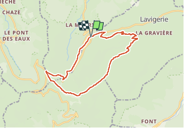
Trail Nordic walking Lavigerie - Col de serre, Puy Mary, Peyre Arse - Photo

Col de serre, Puy Mary, Peyre Arse

 papiphil
papiphil

User

© OpenStreetMap contributors
Length
Length
16 km
Max alt
Max alt
1786 m
Uphill gradient
Uphill gradient
885 m
Km-Effort
Km-Effort  
28 km
Min alt
Min alt
1139 m
Downhill gradient
Downhill gradient
887 m
Boucle
Boucle
Yes
Creation date :
2022-08-03 06:55:46.0
Updated on :
2022-08-07 20:22:32.561

(0 Reviews)

Nordic walking
Nordic walking
5h57
Difficulty : Unknown

Scan this QR Code to open this trail in the SityTrail application

FREE GPS app for hiking

Logo SityTrail SityTrail

IGN / Geographical institutes

Download SityTrail from the App Store Download SityTrail from Google Play

Logo SityTrail SityTrail World

The world is yours!

Download SityTrail from the App Store Download SityTrail from Google Play Download SityTrail on Huawei AppGallery

About

Trail Nordic walking of 16 km to be discovered at Auvergne-Rhône-Alpes, Cantal, Lavigerie. This trail is proposed by papiphil.

Description

Départ du Col de Serre
prendre le chemin qui rejoint le buron
monter jusqu'au pas de Peyrol, puis  Puy Mary
Brèche de Roland , Peyre Arse par la crête
Rejoindre le sentier pour redescendre sur Lavigerie... sans l'atteindre
Apres avoir traversé le ru sur le petit pont , remonter et prendre le chemin sur la gauche Balisé Col de Serre
Une bière bien fraîche nous attend au relai

Elevation profile

Positioning

Country:
France
Region :
Auvergne-Rhône-Alpes
Department/Province :
Cantal
Municipality :
Lavigerie
Location:
Unknown
Start:(UTM)
476588 ; 4997469 (31T) N.

Trails nearby

Trail Walking Lavigerie - Le Puy de Peyre Arse depuis la Gravière - Photo
Walking
tracegps

Walking

Difficult
(2)
Lavigerie, Auvergne-Rhône-Alpes, Cantal, France
11.2 km | 21 km-effort
4h 0min
Yes
Trail Walking Laveissière - Les crêtes du Cantal - Le Lioran - Photo
Walking
tracegps

Walking

Difficult
(4)
Laveissière, Auvergne-Rhône-Alpes, Cantal, France
28 km | 51 km-effort
7h 30min
Yes
Trail Walking Laveissière - le Peyre Arse - Le Lioran - Photo
Walking
tracegps

Walking

Difficult
(1)
Laveissière, Auvergne-Rhône-Alpes, Cantal, France
11.2 km | 19.4 km-effort
4h 0min
No
Trail Walking Laveissière - Lioran 2023-08-18 Col de Rombière Col du Pertus A/R - Photo
Walking
marionneau

Walking

Easy
(1)
Laveissière, Auvergne-Rhône-Alpes, Cantal, France
12.5 km | 18.8 km-effort
4h 14min
Yes
Trail Walking Laveissière - Lioran 2023-08-11 Col du Pertus - Photo
Walking
marionneau

Walking

Medium
(1)
Laveissière, Auvergne-Rhône-Alpes, Cantal, France
17.3 km | 25 km-effort
2h 57min
Yes
Trail Walking Laveissière - Lioran 2023-08-09 Puy de Seycheuse - Photo
Walking
marionneau

Walking

Very difficult
(1)
Laveissière, Auvergne-Rhône-Alpes, Cantal, France
13.9 km | 23 km-effort
5h 20min
Yes
Trail On foot Le Claux - Les Chamois - Photo
On foot
PRO

On foot

Medium
Le Claux, Auvergne-Rhône-Alpes, Cantal, France
17.3 km | 25 km-effort
5h 36min
No
Trail On foot Lavigerie - La Vallée de l'Impradine - Photo
On foot
PRO

On foot

Easy
Lavigerie, Auvergne-Rhône-Alpes, Cantal, France
5.5 km | 7.6 km-effort
1h 44min
Yes
Trail On foot Le Falgoux - Sentier de la cascade du Biaguin - Photo
On foot
PRO

On foot

Easy
Le Falgoux, Auvergne-Rhône-Alpes, Cantal, France
3.8 km | 5.5 km-effort
1h 14min
Yes


Close
My subscriptions