![](/images/other/stat-length.png)
![Trail Walking Fontrabiouse - LAC DE CAMPORELS - Photo](https://media.geolcdn.com/t/1900/400/ext.pjpeg?maxdim=2&url=https%3A%2F%2Fservices.sitytrail.com%2FGeolivesWS%2FDownloadMedia.ashx%3FTrailID%3D333304%26Media%3Dfix__20140809165343.jpg)
LAC DE CAMPORELS
PVERTICAL
User
![Length](/images/other/stat-length.png)
Length
16.9 km
![Max alt](https://static1.geolcdn.com/siteimages/upload/files/1508320355ic_sort_altitude_max_24dp.png)
Max alt
2418 m
![Uphill gradient](https://static1.geolcdn.com/siteimages/upload/files/1508320355ic_sort_den_pos_24dp.png)
Uphill gradient
918 m
![Km-Effort](/images/other/stat-length.png)
Km-Effort
29 km
![Min alt](https://static1.geolcdn.com/siteimages/upload/files/1508320355ic_sort_altitude_min_24dp.png)
Min alt
1603 m
![Downhill gradient](https://static1.geolcdn.com/siteimages/upload/files/1508320355ic_sort_den_neg_24dp.png)
Downhill gradient
922 m
![Boucle](https://static1.geolcdn.com/siteimages/upload/files/16400158638029165_repeat_loop_refresh_sync_direction_icon.png)
Boucle
Yes
Creation date :
2014-12-10 00:00:00.0
Updated on :
2014-12-10 00:00:00.0
![Walking](https://static1.geolcdn.com/sitytour/trail-icons/101.png)
5h02
Difficulty : Medium
![Scan this QR Code to open this trail in the SityTrail application](https://capi.geolives.com/qq0zvz2zws4bq2lad0pu/sitytour/trails/333304/qr.png?size=200)
FREE GPS app for hiking
About
Trail Walking of 16.9 km to be discovered at Occitania, Pyrénées-Orientales, Fontrabiouse. This trail is proposed by PVERTICAL.
Description
Via le hameau d'espousouilles (prendre route forestière à gauche dans le hameau) - faire le retour par même sentier, retour proposé n'a pas grand chose d'intérêt
Positioning
Country:
France
Region :
Occitania
Department/Province :
Pyrénées-Orientales
Municipality :
Fontrabiouse
Location:
Unknown
Start:(Dec)
Start:(UTM)
422589 ; 4720730 (31T) N.
Comments
Trails nearby
![Trail Walking Formiguères - Les Camporells par la Lladure - Photo](https://media.geolcdn.com/t/375/260/ext.jpg?maxdim=2&url=https%3A%2F%2Fstatic1.geolcdn.com%2Fsiteimages%2Fupload%2Ffiles%2F1553511878bg_sport_marche.png)
![Walking Walking](https://static1.geolcdn.com/sitytour/trail-icons/101.png)
Les Camporells par la Lladure
Walking
Medium
(1)
Formiguères,
Occitania,
Pyrénées-Orientales,
France
![](/images/other/stat-length.png)
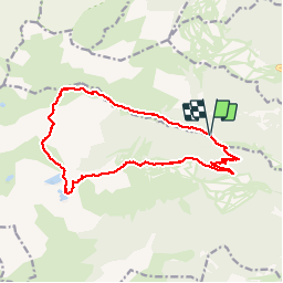
15.1 km | 24 km-effort
5h 7min
![](https://static1.geolcdn.com/siteimages/upload/files/16400158638029165_repeat_loop_refresh_sync_direction_icon.png)
Yes
![Trail sport Formiguères - 20240728 Station Formiguères - Camporeils - Photo](https://media.geolcdn.com/t/375/260/f876415d-ce02-429d-b141-5520f07207a5.jpg&format=jpg&maxdim=2)
20240728 Station Formiguères - Camporeils
sport
Very easy
Formiguères,
Occitania,
Pyrénées-Orientales,
France
![](/images/other/stat-length.png)
16 km | 27 km-effort
Unknown
![](https://static1.geolcdn.com/siteimages/upload/files/16400158638029165_repeat_loop_refresh_sync_direction_icon.png)
Yes
![Trail Walking Formiguères - 20210819 Porteille d’Orlu, étang du diable - Photo](https://media.geolcdn.com/t/375/260/dda65196-4e65-40c0-ab96-37c7b8dfe61a.jpg&format=jpg&maxdim=2)
![Walking Walking](https://static1.geolcdn.com/sitytour/trail-icons/101.png)
20210819 Porteille d’Orlu, étang du diable
Walking
Difficult
Formiguères,
Occitania,
Pyrénées-Orientales,
France
![](/images/other/stat-length.png)
16.4 km | 29 km-effort
5h 3min
![](https://static1.geolcdn.com/siteimages/upload/files/16400158638029165_repeat_loop_refresh_sync_direction_icon.png)
Yes
![Trail Walking Formiguères - 20210710 pla del bosc - Foumigueres - Photo](https://media.geolcdn.com/t/375/260/1179261a-6605-4660-a8d9-78a9473ad380.jpg&format=jpg&maxdim=2)
![Walking Walking](https://static1.geolcdn.com/sitytour/trail-icons/101.png)
20210710 pla del bosc - Foumigueres
Walking
Easy
Formiguères,
Occitania,
Pyrénées-Orientales,
France
![](/images/other/stat-length.png)
12.5 km | 18.3 km-effort
2h 47min
![](https://static1.geolcdn.com/siteimages/upload/files/16400158638029165_repeat_loop_refresh_sync_direction_icon.png)
Yes
![Trail Snowshoes Formiguères - Formigueres el collet - Photo](https://media.geolcdn.com/t/375/260/fd8d553e-fbbc-4eac-9bcd-8fe4718e94f2.jpg&format=jpg&maxdim=2)
![Snowshoes Snowshoes](https://static1.geolcdn.com/sitytour/trail-icons/504.png)
Formigueres el collet
Snowshoes
Very easy
Formiguères,
Occitania,
Pyrénées-Orientales,
France
![](/images/other/stat-length.png)
6.4 km | 8.7 km-effort
2h 47min
![](https://static1.geolcdn.com/siteimages/upload/files/16400158638029165_repeat_loop_refresh_sync_direction_icon.png)
Yes
![Trail Walking Puyvalador - Rieutort - Photo](https://media.geolcdn.com/t/375/260/6a994d33-6cf7-4c4a-aa34-3e717cb1dad9.jpg&format=jpg&maxdim=2)
![Walking Walking](https://static1.geolcdn.com/sitytour/trail-icons/101.png)
Rieutort
Walking
Puyvalador,
Occitania,
Pyrénées-Orientales,
France
![](/images/other/stat-length.png)
7.8 km | 12.9 km-effort
2h 26min
![](https://static1.geolcdn.com/siteimages/upload/files/16400158638029165_repeat_loop_refresh_sync_direction_icon.png)
Yes
![Trail Walking Formiguères - Station Formiguères lacs de camporells_T - Photo](https://media.geolcdn.com/t/375/260/710ef9d8-98d3-4b56-a5eb-3d5b563cc687.jpg&format=jpg&maxdim=2)
![Walking Walking](https://static1.geolcdn.com/sitytour/trail-icons/101.png)
Station Formiguères lacs de camporells_T
Walking
Medium
Formiguères,
Occitania,
Pyrénées-Orientales,
France
![](/images/other/stat-length.png)
17.3 km | 29 km-effort
8h 15min
![](https://static1.geolcdn.com/siteimages/upload/files/16400158638029165_repeat_loop_refresh_sync_direction_icon.png)
Yes
![Trail Walking Formiguères - La Porteil.d Orlu au départ de Formiguères - Photo](https://media.geolcdn.com/t/375/260/ext.jpg?maxdim=2&url=https%3A%2F%2Fservices.sitytrail.com%2FGeolivesWS%2FDownloadMedia.ashx%3FTrailID%3D1015795%26Media%3Dfix__20180802113925.jpg)
![Walking Walking](https://static1.geolcdn.com/sitytour/trail-icons/101.png)
La Porteil.d Orlu au départ de Formiguères
Walking
Medium
Formiguères,
Occitania,
Pyrénées-Orientales,
France
![](/images/other/stat-length.png)
17.9 km | 30 km-effort
6h 36min
![](https://static1.geolcdn.com/siteimages/upload/files/16400158638029165_repeat_loop_refresh_sync_direction_icon.png)
Yes
![Trail Walking Formiguères - lacs des Camporells depuis le haut des pistes de Formigueres - Photo](https://media.geolcdn.com/t/375/260/ext.jpg?maxdim=2&url=https%3A%2F%2Fservices.sitytrail.com%2FGeolivesWS%2FDownloadMedia.ashx%3FTrailID%3D783076%26Media%3D20170703113851.jpg)
![Walking Walking](https://static1.geolcdn.com/sitytour/trail-icons/101.png)
lacs des Camporells depuis le haut des pistes de Formigueres
Walking
Medium
Formiguères,
Occitania,
Pyrénées-Orientales,
France
![](/images/other/stat-length.png)
11.3 km | 18.3 km-effort
3h 31min
![](https://static1.geolcdn.com/siteimages/upload/files/16400158638029165_repeat_loop_refresh_sync_direction_icon.png)
Yes