Trail Walking La Giettaz - La Giettaz - La Tête du Torraz - Photo

La Giettaz - La Tête du Torraz

 wbarge
wbarge

User

© OpenStreetMap contributors
Length
Length
10 km
Max alt
Max alt
1922 m
Uphill gradient
Uphill gradient
847 m
Km-Effort
Km-Effort  
21 km
Min alt
Min alt
1073 m
Downhill gradient
Downhill gradient
846 m
Boucle
Boucle
Yes
Creation date :
2014-12-10 00:00:00.0
Updated on :
2014-12-10 00:00:00.0

(0 Reviews)

Walking
Walking
5h57
Difficulty : Difficult

Scan this QR Code to open this trail in the SityTrail application

FREE GPS app for hiking

Logo SityTrail SityTrail

IGN / Geographical institutes

Download SityTrail from the App Store Download SityTrail from Google Play

Logo SityTrail SityTrail World

The world is yours!

Download SityTrail from the App Store Download SityTrail from Google Play Download SityTrail on Huawei AppGallery

About

Trail Walking of 10 km to be discovered at Auvergne-Rhône-Alpes, Savoy, La Giettaz. This trail is proposed by wbarge.

Description

Aller-retour La Giettaz-La tête du Torraz.
1/3 du parcours difficile lorsque les derniers jours ont été humides.

Elevation profile

Positioning

Country:
France
Region :
Auvergne-Rhône-Alpes
Department/Province :
Savoy
Municipality :
La Giettaz
Location:
Unknown
Start:(UTM)
305595 ; 5081670 (32T) N.

Trails nearby

Trail Walking La Giettaz - Le Plan - col de Jaillet - Photo
Walking
wbarge

Walking

Medium
(2)
La Giettaz, Auvergne-Rhône-Alpes, Savoy, France
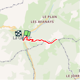
11.9 km | 19.7 km-effort
4h 18min
Yes
Trail Touring skiing Praz-sur-Arly - Tête du Torraz - Photo
Touring skiing
GUIDE
nadd73

Touring skiing

Easy
Praz-sur-Arly, Auvergne-Rhône-Alpes, Upper Savoy, France
12.8 km | 25 km-effort
4h 36min
Yes
Trail Walking Ugine - la Gouenne, la rouelle, la tête de l'aupt - Photo
Walking
GUIDE
nadd73

Walking

Difficult
Ugine, Auvergne-Rhône-Alpes, Savoy, France
7.8 km | 19.8 km-effort
5h 25min
Yes
Trail Walking La Giettaz - Boucle de Croisse Baulet - Photo
Walking
olivecoco

Walking

Medium
(1)
La Giettaz, Auvergne-Rhône-Alpes, Savoy, France
9.4 km | 23 km-effort
4h 2min
Yes
Trail Snowshoes La Clusaz - col aravis - Photo
Snowshoes
myjackotte

Snowshoes

Easy
(2)
La Clusaz, Auvergne-Rhône-Alpes, Upper Savoy, France
5.7 km | 8.2 km-effort
2h 16min
Yes
Trail Other activity La Giettaz - croise baulet - Photo
Other activity
twistss

Other activity

Very easy
(3)
La Giettaz, Auvergne-Rhône-Alpes, Savoy, France
12.1 km | 27 km-effort
3h 30min
Yes
Trail Walking Saint-Nicolas-la-Chapelle - SAINT NICOLAS LA CHAPELLE - Photo
Walking
albertville

Walking

Very easy
(1)
Saint-Nicolas-la-Chapelle, Auvergne-Rhône-Alpes, Savoy, France
9.5 km | 16.8 km-effort
3h 41min
No
Trail Motor La Giettaz - La Giettaz - Col des Aravis - Photo
Motor
albertville

Motor

Very easy
(1)
La Giettaz, Auvergne-Rhône-Alpes, Savoy, France
15.8 km | 23 km-effort
58min
No
Trail Walking La Clusaz - aravis aiguille verte combe borderan 12kms  987m - Photo
Walking
GUIDE
Danielba

Walking

Medium
La Clusaz, Auvergne-Rhône-Alpes, Upper Savoy, France
11.6 km | 25 km-effort
7h 14min
Yes


Close
My subscriptions