![](/images/other/stat-length.png)
![Trail Walking Angoustrine-Villeneuve-des-Escaldes - Pic Carlit (2921m) au départ des Bouillouses - Photo](https://media.geolcdn.com/t/1900/400/c97949b1-ceb8-4f18-924e-7d29c36185d3.jpg&format=pjpeg&maxdim=2)
Pic Carlit (2921m) au départ des Bouillouses
toutankhcarton
User GUIDE
![Length](/images/other/stat-length.png)
Length
14.8 km
![Max alt](https://static1.geolcdn.com/siteimages/upload/files/1508320355ic_sort_altitude_max_24dp.png)
Max alt
2885 m
![Uphill gradient](https://static1.geolcdn.com/siteimages/upload/files/1508320355ic_sort_den_pos_24dp.png)
Uphill gradient
916 m
![Km-Effort](/images/other/stat-length.png)
Km-Effort
27 km
![Min alt](https://static1.geolcdn.com/siteimages/upload/files/1508320355ic_sort_altitude_min_24dp.png)
Min alt
2007 m
![Downhill gradient](https://static1.geolcdn.com/siteimages/upload/files/1508320355ic_sort_den_neg_24dp.png)
Downhill gradient
908 m
![Boucle](https://static1.geolcdn.com/siteimages/upload/files/16400158638029165_repeat_loop_refresh_sync_direction_icon.png)
Boucle
Yes
Creation date :
2022-07-22 05:00:34.936
Updated on :
2022-07-22 15:12:51.376
![Walking](https://static1.geolcdn.com/sitytour/trail-icons/101.png)
5h04
Difficulty : Difficult
![Scan this QR Code to open this trail in the SityTrail application](https://capi.geolives.com/qq0zvz2zws4bq2lad0pu/sitytour/trails/3325252/qr.png?size=200)
FREE GPS app for hiking
About
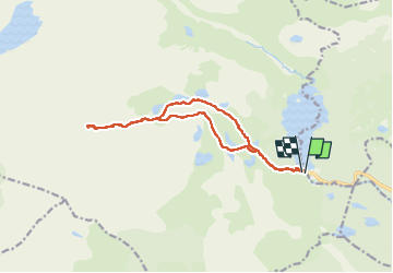
Trail Walking of 14.8 km to be discovered at Occitania, Pyrénées-Orientales, Angoustrine-Villeneuve-des-Escaldes. This trail is proposed by toutankhcarton.
Description
Point culminant du département des Pyrénées Orientales.
Ascension par les Bouillouses. La dernière partie de l’ascension est raide, et nécessite de poser les mains.
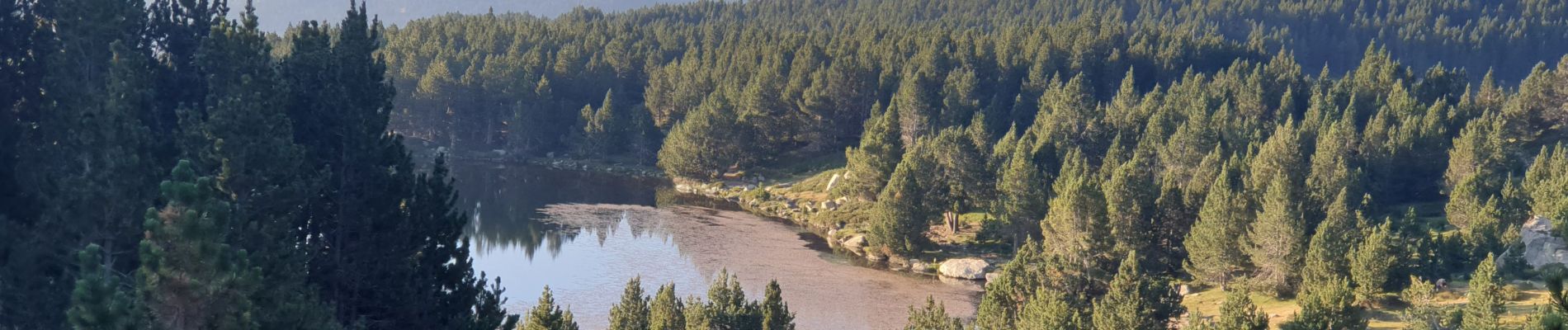
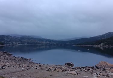
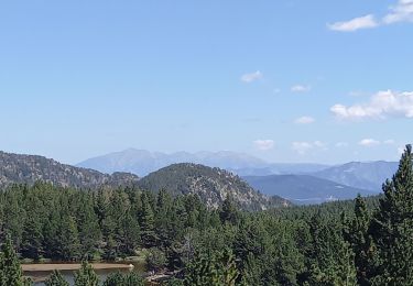
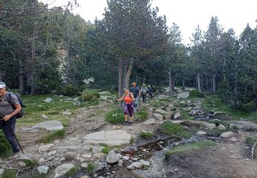
Positioning
Country:
France
Region :
Occitania
Department/Province :
Pyrénées-Orientales
Municipality :
Angoustrine-Villeneuve-des-Escaldes
Location:
Unknown
Start:(Dec)
Start:(UTM)
417922 ; 4712375 (31T) N.
Comments
Trails nearby
![Trail Walking Font-Romeu-Odeillo-Via - Coll del Pam lac des Bouillouses - Photo](https://media.geolcdn.com/t/375/260/ext.jpg?maxdim=2&url=https%3A%2F%2Fservices.sitytrail.com%2FGeolivesWS%2FDownloadMedia.ashx%3FTrailID%3D802013%26Media%3Dfix__20170803141713.jpg)
![Walking Walking](https://static1.geolcdn.com/sitytour/trail-icons/101.png)
Coll del Pam lac des Bouillouses
Walking
Medium
(2)
Font-Romeu-Odeillo-Via,
Occitania,
Pyrénées-Orientales,
France
![](/images/other/stat-length.png)
13.3 km | 19.3 km-effort
4h 10min
![](https://static1.geolcdn.com/siteimages/upload/files/16400158638029165_repeat_loop_refresh_sync_direction_icon.png)
Yes
![Trail Walking Les Angles - le tour des lacs de carli - Photo](https://media.geolcdn.com/t/375/260/ext.jpg?maxdim=2&url=https%3A%2F%2Fservices.sitytrail.com%2FGeolivesWS%2FDownloadMedia.ashx%3FTrailID%3D205430%26Media%3Dfix__20130716110753.jpg)
![Walking Walking](https://static1.geolcdn.com/sitytour/trail-icons/101.png)
le tour des lacs de carli
Walking
Medium
(2)
Les Angles,
Occitania,
Pyrénées-Orientales,
France
![](/images/other/stat-length.png)
11.4 km | 16.6 km-effort
3h 51min
![](https://static1.geolcdn.com/siteimages/upload/files/16400158638029165_repeat_loop_refresh_sync_direction_icon.png)
No
![Trail Walking Les Angles - Rando des 12 lacs - Photo](https://media.geolcdn.com/t/375/260/ext.jpg?maxdim=2&url=https%3A%2F%2Fservices.sitytrail.com%2FGeolivesWS%2FDownloadMedia.ashx%3FTrailID%3D136989%26Media%3D20120701094842.jpg)
![Walking Walking](https://static1.geolcdn.com/sitytour/trail-icons/101.png)
Rando des 12 lacs
Walking
Easy
(1)
Les Angles,
Occitania,
Pyrénées-Orientales,
France
![](/images/other/stat-length.png)
14.1 km | 20 km-effort
6h 30min
![](https://static1.geolcdn.com/siteimages/upload/files/16400158638029165_repeat_loop_refresh_sync_direction_icon.png)
Yes
![Trail Walking Les Angles - mon tour des lacs de bouillouse - Photo](https://media.geolcdn.com/t/375/260/2648e5b5-c40e-4b9e-985b-6f349e494b8d.jpg&format=jpg&maxdim=2)
![Walking Walking](https://static1.geolcdn.com/sitytour/trail-icons/101.png)
mon tour des lacs de bouillouse
Walking
Medium
Les Angles,
Occitania,
Pyrénées-Orientales,
France
![](/images/other/stat-length.png)
11.4 km | 16.6 km-effort
5h 27min
![](https://static1.geolcdn.com/siteimages/upload/files/16400158638029165_repeat_loop_refresh_sync_direction_icon.png)
Yes
![Trail Walking Les Angles - les 12 lacs Les Fouillousses - Photo](https://media.geolcdn.com/t/375/260/bb85e097-75b6-4a16-8929-0b243dd59c16.jpg&format=jpg&maxdim=2)
![Walking Walking](https://static1.geolcdn.com/sitytour/trail-icons/101.png)
les 12 lacs Les Fouillousses
Walking
Medium
Les Angles,
Occitania,
Pyrénées-Orientales,
France
![](/images/other/stat-length.png)
12.1 km | 17.9 km-effort
5h 19min
![](https://static1.geolcdn.com/siteimages/upload/files/16400158638029165_repeat_loop_refresh_sync_direction_icon.png)
Yes
![Trail Walking Les Angles - les Angles - Photo](https://media.geolcdn.com/t/375/260/a1624f8b-9696-405f-8c28-1fd4c2634375.jpg&format=jpg&maxdim=2)
![Walking Walking](https://static1.geolcdn.com/sitytour/trail-icons/101.png)
les Angles
Walking
Difficult
Les Angles,
Occitania,
Pyrénées-Orientales,
France
![](/images/other/stat-length.png)
14.5 km | 20 km-effort
4h 58min
![](https://static1.geolcdn.com/siteimages/upload/files/16400158638029165_repeat_loop_refresh_sync_direction_icon.png)
No
![Trail Nordic walking Font-Romeu-Odeillo-Via - mauroux - Photo](https://media.geolcdn.com/t/375/260/ext.jpg?maxdim=2&url=https%3A%2F%2Fstatic1.geolcdn.com%2Fsiteimages%2Fupload%2Ffiles%2F1545311037marcheuse_200dpi.jpg)
![Nordic walking Nordic walking](https://static1.geolcdn.com/sitytour/trail-icons/102.png)
mauroux
Nordic walking
Medium
(2)
Font-Romeu-Odeillo-Via,
Occitania,
Pyrénées-Orientales,
France
![](/images/other/stat-length.png)
11.2 km | 14.7 km-effort
1h 20min
![](https://static1.geolcdn.com/siteimages/upload/files/16400158638029165_repeat_loop_refresh_sync_direction_icon.png)
Yes
![Trail Walking Les Angles - Boucle du lac d'Aude - Photo](https://media.geolcdn.com/t/375/260/ext.jpg?maxdim=2&url=https%3A%2F%2Fstatic1.geolcdn.com%2Fsiteimages%2Fupload%2Ffiles%2F1553511878bg_sport_marche.png)
![Walking Walking](https://static1.geolcdn.com/sitytour/trail-icons/101.png)
Boucle du lac d'Aude
Walking
Very easy
(1)
Les Angles,
Occitania,
Pyrénées-Orientales,
France
![](/images/other/stat-length.png)
11.1 km | 16.8 km-effort
3h 36min
![](https://static1.geolcdn.com/siteimages/upload/files/16400158638029165_repeat_loop_refresh_sync_direction_icon.png)
No
![Trail Walking Les Angles - carlit 2024 - Photo](https://media.geolcdn.com/t/375/260/1851c0fe-6bdb-4f7c-9186-d716db284dfb.jpg&format=jpg&maxdim=2)
![Walking Walking](https://static1.geolcdn.com/sitytour/trail-icons/101.png)
carlit 2024
Walking
Difficult
Les Angles,
Occitania,
Pyrénées-Orientales,
France
![](/images/other/stat-length.png)
17.3 km | 30 km-effort
9h 9min
![](https://static1.geolcdn.com/siteimages/upload/files/16400158638029165_repeat_loop_refresh_sync_direction_icon.png)
No